Monticello, Florida
| Monticello, Florida | |
|---|---|
City | |
 Monticello City Hall | |
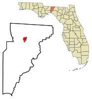 Location in Jefferson County and the state of Florida | |
Coordinates: 30°32′41″N 83°52′2″W / 30.54472°N 83.86722°W / 30.54472; -83.86722Coordinates: 30°32′41″N 83°52′2″W / 30.54472°N 83.86722°W / 30.54472; -83.86722 | |
| Country | |
| State | |
| County | Jefferson |
| Government | |
| • Mayor | Troy Avera[1] |
| Area[2] | |
| • Total | 3.98 sq mi (10.30 km2) |
| • Land | 3.98 sq mi (10.30 km2) |
| • Water | 0.00 sq mi (0.00 km2) |
| Elevation | 233 ft (71 m) |
| Population (2010) | |
| • Total | 2,506 |
| • Estimate (2016)[3] | 2,402 |
| • Density | 632.4/sq mi (244.16/km2) |
| Time zone | UTC-5 (Eastern (EST)) |
| • Summer (DST) | UTC-4 (EDT) |
| ZIP codes | 32344-32345 |
| Area code(s) | 850 |
| FIPS code | 12-46500[4] |
GNIS feature ID | 0287080[5] |
| Website | www.cityofmonticello.us |
Monticello is a city in Jefferson County, Florida, United States. The population was 2,506 at the 2010 census.[6] It is the county seat of Jefferson County.[7] The city is named after Monticello, the estate of the county's namesake, Thomas Jefferson, on which the county courthouse was modeled.[8]
Monticello is home to Indian mounds and many historic buildings, including the Perkins Opera House and Monticello Old Jail Museum.
Contents
1 Geography
2 Demographics
3 Climate
4 History and culture
4.1 Historic sites
5 Pronunciation
6 References
7 External links
Geography
Monticello is located in northern Jefferson County at 30°32′41″N 83°52′02″W / 30.544612°N 83.867321°W / 30.544612; -83.867321.[9]U.S. Route 90 runs through the center of the city as Washington Street, leading east 16 miles (26 km) to Greenville and west 26 miles (42 km) to Tallahassee. U.S. Route 19 passes through the city center on Jefferson Street, leading south 10 miles (16 km) to Capps and north 22 miles (35 km) to Thomasville, Georgia. The two highways meet in the center of Monticello at Courthouse Circle, which surrounds the Jefferson County Courthouse. US-19 leads south from the courthouse 5 miles (8 km) to Interstate 10 at Exit 225. I-10 leads west 25 miles (40 km) to Tallahassee and east 82 miles (132 km) to Lake City.
According to the United States Census Bureau, the city has a total area of 4.0 square miles (10.3 km2), all land.[6]
Demographics
| Historical population | |||
|---|---|---|---|
| Census | Pop. | %± | |
| 1850 | 329 | — | |
| 1860 | 1,083 | 229.2% | |
| 1870 | 1,052 | −2.9% | |
| 1890 | 1,218 | — | |
| 1900 | 1,076 | −11.7% | |
| 1910 | 1,829 | 70.0% | |
| 1920 | 1,704 | −6.8% | |
| 1930 | 1,901 | 11.6% | |
| 1940 | 2,042 | 7.4% | |
| 1950 | 2,264 | 10.9% | |
| 1960 | 2,490 | 10.0% | |
| 1970 | 2,473 | −0.7% | |
| 1980 | 2,994 | 21.1% | |
| 1990 | 2,573 | −14.1% | |
| 2000 | 2,533 | −1.6% | |
| 2010 | 2,506 | −1.1% | |
| Est. 2016 | 2,402 | [3] | −4.2% |
| U.S. Decennial Census[10] | |||
As of the census[4] of 2000, there were 2,533 people, 973 households, and 664 families residing in the city. The population density was 749.4 people per square mile (289.3/km²). There were 1,088 housing units at an average density of 321.9 per square mile (124.3/km²). The racial makeup of the city was 47.06% White, 50.85% African American, 0.12% Native American, 0.59% Asian, 0.08% Pacific Islander, 0.43% from other races, and 0.87% from two or more races. Hispanic or Latino of any race were 1.30% of the population.
There were 973 households out of which 29.3% had children under the age of 18 living with them, 41.3% were married couples living together, 23.5% had a female householder with no husband present, and 31.7% were non-families. 27.6% of all households were made up of individuals and 11.5% had someone living alone who was 65 years of age or older. The average household size was 2.48 and the average family size was 3.03.
In the city, the population was spread out with 25.1% under the age of 18, 9.0% from 18 to 24, 24.6% from 25 to 44, 22.7% from 45 to 64, and 18.6% who were 65 years of age or older. The median age was 39 years. For every 100 females, there were 79.5 males. For every 100 females age 18 and over, there were 73.3 males.
The median income for a household in the city was $28,720, and the median income for a family was $32,356. Males had a median income of $25,932 versus $21,760 for females. The per capita income for the city was $15,522. About 18.5% of families and 22.2% of the population were below the poverty line, including 27.2% of those under age 18 and 14.4% of those age 65 or over.
Climate
The climate in this area is characterized by hot, humid summers and generally mild to cool winters. According to the Köppen Climate Classification system, Monticello has a humid subtropical climate, abbreviated "Cfa" on climate maps.[11]
Monticello is the site of the highest temperature recorded in Florida, 109 °F (43 °C) on June 29, 1931.[12]
| Climate data for Monticello, Florida | |||||||||||||
|---|---|---|---|---|---|---|---|---|---|---|---|---|---|
| Month | Jan | Feb | Mar | Apr | May | Jun | Jul | Aug | Sep | Oct | Nov | Dec | Year |
| Record high °C (°F) | 29 (84) | 31 (88) | 33 (92) | 39 (103) | 41 (106) | 43 (109) | 41 (105) | 39 (102) | 40 (104) | 38 (100) | 34 (94) | 32 (89) | 43 (109) |
| Average high °C (°F) | 18 (64) | 19 (66) | 23 (73) | 26 (79) | 30 (86) | 32 (90) | 33 (91) | 32 (90) | 31 (88) | 27 (81) | 22 (72) | 18 (65) | 26 (79) |
| Average low °C (°F) | 5 (41) | 6 (42) | 9 (48) | 12 (54) | 16 (61) | 20 (68) | 21 (70) | 21 (70) | 19 (67) | 13 (56) | 8 (47) | 5 (41) | 13 (55) |
| Record low °C (°F) | −16 (4) | −18 (0) | −8 (18) | −2 (29) | 3 (38) | 7 (44) | 12 (54) | 14 (58) | 2 (36) | −2 (28) | −11 (13) | −14 (7) | −18 (0) |
| Average precipitation mm (inches) | 112 (4.4) | 114 (4.5) | 124 (4.9) | 99 (3.9) | 99 (3.9) | 150 (5.9) | 180 (7.1) | 165 (6.5) | 130 (5) | 71 (2.8) | 71 (2.8) | 100 (4) | 1,412 (55.6) |
| Source: Weatherbase [13] | |||||||||||||
History and culture
Monticello has a historic 19th century opera house that still features regular musical performances, as well as theater productions and musicals. The first floor ballroom also holds receptions on a regular basis.
Historic sites
- Bethel School
- Christ Episcopal Church
- Denham-Lacy House
- Jefferson County Courthouse (Florida)
- Letchworth Mounds
- Lyndhurst Plantation
- Monticello High School (Florida)
- Monticello Historic District
- Palmer House
- Palmer-Perkins House
- Perkins Opera House
- Wirick-Simmons House
- Monticello Old Jail Museum
Pronunciation
Unlike Thomas Jefferson's home in Virginia, the city in Florida is pronounced "mont-i-SEL-o," not "mont-i-CHEL-o."[citation needed]
References
^ "Mayor Tom Vogelgesang resigns office -". 6 April 2017..mw-parser-output cite.citation{font-style:inherit}.mw-parser-output q{quotes:"""""""'""'"}.mw-parser-output code.cs1-code{color:inherit;background:inherit;border:inherit;padding:inherit}.mw-parser-output .cs1-lock-free a{background:url("//upload.wikimedia.org/wikipedia/commons/thumb/6/65/Lock-green.svg/9px-Lock-green.svg.png")no-repeat;background-position:right .1em center}.mw-parser-output .cs1-lock-limited a,.mw-parser-output .cs1-lock-registration a{background:url("//upload.wikimedia.org/wikipedia/commons/thumb/d/d6/Lock-gray-alt-2.svg/9px-Lock-gray-alt-2.svg.png")no-repeat;background-position:right .1em center}.mw-parser-output .cs1-lock-subscription a{background:url("//upload.wikimedia.org/wikipedia/commons/thumb/a/aa/Lock-red-alt-2.svg/9px-Lock-red-alt-2.svg.png")no-repeat;background-position:right .1em center}.mw-parser-output .cs1-subscription,.mw-parser-output .cs1-registration{color:#555}.mw-parser-output .cs1-subscription span,.mw-parser-output .cs1-registration span{border-bottom:1px dotted;cursor:help}.mw-parser-output .cs1-hidden-error{display:none;font-size:100%}.mw-parser-output .cs1-visible-error{font-size:100%}.mw-parser-output .cs1-subscription,.mw-parser-output .cs1-registration,.mw-parser-output .cs1-format{font-size:95%}.mw-parser-output .cs1-kern-left,.mw-parser-output .cs1-kern-wl-left{padding-left:0.2em}.mw-parser-output .cs1-kern-right,.mw-parser-output .cs1-kern-wl-right{padding-right:0.2em}
^ "2016 U.S. Gazetteer Files". United States Census Bureau. Retrieved Jul 7, 2017.
^ ab "Population and Housing Unit Estimates". Retrieved June 9, 2017.
^ ab "American FactFinder". United States Census Bureau. Retrieved 2008-01-31.
^ "US Board on Geographic Names". United States Geological Survey. 2007-10-25. Retrieved 2008-01-31.
^ ab "Geographic Identifiers: 2010 Census Summary File 1 (G001): Monticello city, Florida". American Factfinder. U.S. Census Bureau. Retrieved April 30, 2018.
^ "Find a County". National Association of Counties. Retrieved 2011-06-07.
^ Federal Writers' Project (1939), Florida. A Guide to the Southernmost State, New York: Oxford University Press, p. 438|access-date=requires|url=(help)
^ "US Gazetteer files: 2010, 2000, and 1990". United States Census Bureau. 2011-02-12. Retrieved 2011-04-23.
^ "Census of Population and Housing". Census.gov. Retrieved June 4, 2015.
^ "Monticello, Florida Köppen Climate Classification (Weatherbase)". Weatherbase.
^ "Record Highs: Florida's Warmest Days". Climate Design. Retrieved 21 June 2017.
^
"Weatherbase.com". Weatherbase. 2013.
Retrieved on October 15, 2013.
External links
- City of Monticello official website
- Jefferson County, Florida
- Jefferson County Economic Development Council
Monticello News newspaper that serves Monticello, Florida is available in full-text with images in Florida Digital Newspaper Library
- Jefferson County Tourist Development Council
- Monticello Opera House
Municipalities and communities of Jefferson County, Florida, United States | ||
|---|---|---|
County seat: Monticello | ||
| City |
|  |
| CDPs |
| |
| Unincorporated communities |
| |
| Ghost towns |
| |
| Plantations |
| |
| Footnote |
| |


