A58 road
A58 | |
|---|---|
 | |
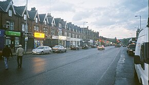 Harehills Parade, A58, Roundhay Road, Harehills, Leeds (towards Wetherby) | |
| Route information | |
| Length | 75 mi (121 km) |
| Major junctions | |
| West end | Prescot |
| East end | Wetherby |
| Location | |
| Primary destinations | St Helens Bolton Bury Rochdale Halifax Leeds |
| Road network | |
| |

The A58 is a major road in Northern England that runs between Prescot, Merseyside and Wetherby, West Yorkshire.
It runs north east from Prescot on the outskirts of Liverpool via St Helens, Ashton-in-Makerfield, Hindley, Westhoughton, Bolton, Bury, Heywood, Rochdale and Littleborough, then over the Pennines into West Yorkshire.
The road then goes through Ripponden and Sowerby Bridge to Halifax and onwards to Leeds via the villages of Hipperholme, Birkenshaw and Drighlington. It runs through Leeds as the A58(M) motorway (part of the Leeds Inner Ring Road), then north-east through Scarcroft, Bardsey and Collingham to its terminus at Wetherby.
The original route between Leeds and Wetherby was bypassed with a new dual carriageway diverting from Roundhay Road/ Wetherby Road, at the old Fforde Grene junction in Harehills. It runs along the Easterly Road dual carriageway passing Oakwood and Gipton. The re-routed A58 meets its original route at Boggart Hill in Seacroft. The re-routed section was constructed in the 1930s and had a branch of the Leeds Tramway running along the central reservation until the 1950s.[1] The proposed Leeds Supertram was also to run this route.[2]
Gallery

Terminus of the road in Micklethwaite, Wetherby, West Yorkshire
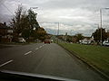
A58 easterly road separating Oakwood and Gipton in Leeds

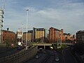
A58(M), Leeds Inner Ring Road by the Leeds International Pool
A58(M), Leeds Inner Ring Road passing underneath the Nuffield Hospital


References
^ Buckley, Richard (2011). Leeds Trams 1871-1959. Catrine: Stenlake. p. 54. ISBN 9781840335309..mw-parser-output cite.citation{font-style:inherit}.mw-parser-output .citation q{quotes:"""""""'""'"}.mw-parser-output .citation .cs1-lock-free a{background:url("//upload.wikimedia.org/wikipedia/commons/thumb/6/65/Lock-green.svg/9px-Lock-green.svg.png")no-repeat;background-position:right .1em center}.mw-parser-output .citation .cs1-lock-limited a,.mw-parser-output .citation .cs1-lock-registration a{background:url("//upload.wikimedia.org/wikipedia/commons/thumb/d/d6/Lock-gray-alt-2.svg/9px-Lock-gray-alt-2.svg.png")no-repeat;background-position:right .1em center}.mw-parser-output .citation .cs1-lock-subscription a{background:url("//upload.wikimedia.org/wikipedia/commons/thumb/a/aa/Lock-red-alt-2.svg/9px-Lock-red-alt-2.svg.png")no-repeat;background-position:right .1em center}.mw-parser-output .cs1-subscription,.mw-parser-output .cs1-registration{color:#555}.mw-parser-output .cs1-subscription span,.mw-parser-output .cs1-registration span{border-bottom:1px dotted;cursor:help}.mw-parser-output .cs1-ws-icon a{background:url("//upload.wikimedia.org/wikipedia/commons/thumb/4/4c/Wikisource-logo.svg/12px-Wikisource-logo.svg.png")no-repeat;background-position:right .1em center}.mw-parser-output code.cs1-code{color:inherit;background:inherit;border:inherit;padding:inherit}.mw-parser-output .cs1-hidden-error{display:none;font-size:100%}.mw-parser-output .cs1-visible-error{font-size:100%}.mw-parser-output .cs1-maint{display:none;color:#33aa33;margin-left:0.3em}.mw-parser-output .cs1-subscription,.mw-parser-output .cs1-registration,.mw-parser-output .cs1-format{font-size:95%}.mw-parser-output .cs1-kern-left,.mw-parser-output .cs1-kern-wl-left{padding-left:0.2em}.mw-parser-output .cs1-kern-right,.mw-parser-output .cs1-kern-wl-right{padding-right:0.2em}
^ "Leeds Supertram Route Map". Railway Technology. Retrieved 20 March 2016.
- Google map of A58
External links
![]() Media related to A58 road at Wikimedia Commons
Media related to A58 road at Wikimedia Commons
A roads in Zone 5 of the Great Britain road numbering scheme | ||
|---|---|---|
| ||
| ||
| ||
| ||
Coordinates: 53°54′18″N 2°09′01″W / 53.90499°N 2.15023°W / 53.90499; -2.15023
This England road or road transport-related article is a stub. You can help Wikipedia by expanding it. |


