Bergamasque Alps
| Alpi Orobie | |
|---|---|
Bergamasque Alps Bergamo Alps | |
 Bergamo Alps, section no. 68 in the scheme proposed by SOIUSA | |
| Highest point | |
| Peak | Pizzo di Coca |
| Elevation | 3,052 m (10,013 ft) |
| Coordinates | 46°05′N 09°47′E / 46.083°N 9.783°E / 46.083; 9.783 |
| Geography | |
| Country | Bergamo, |
| State/Province | Lombardy |
| Range coordinates | 46°N 10°E / 46°N 10°E / 46; 10Coordinates: 46°N 10°E / 46°N 10°E / 46; 10 |
| Parent range | Bergamasque Alps and Prealps |
| Borders on | List
|
| Geology | |
| Orogeny | Alpine orogeny |

Corna Piana

Pizzo Arera

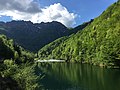
Lake Barbellino
The Bergamasque Alps or Bergamo Alps (Italian: Alpi Orobie) are a mountain range in the Italian Alps. They are located in northern Lombardy and named after the city Bergamo, south of the mountains. Within the Eastern Alps, the Alpine Club or AVE system places them within the Western Limestone Alps, while the SOIUSA system classifies them within the Southeastern Alps.
Contents
1 Peaks
2 Gallery
3 Passes
4 See also
5 References
Peaks
The main peaks of the Bergamasque Alps are:
| Peak | Elevation | |
|---|---|---|
| (m) | (ft) | |
| Pizzo di Coca | 3,052 | 10,014 |
| Pizzo di Scais | 3,040 | 9,974 |
| Pizzo Redorta | 3,037 | 9,964 |
| Pizzo del Diavolo di Tenda | 2,915 | 9,564 |
| Pizzo Recastello | 2,888 | 9,475 |
| Monte Gleno | 2,883 | 9,459 |
| Pizzo Tornello | 2,688 | 8,819 |
| Corno Stella | 2,620 | 8,596 |
| Monte Legnone | 2,610 | 8,563 |
| Pizzo dei Tre Signori | 2,554 | 8,380 |
| Monte Toro | 2,524 | 8,281 |
| Pizzo Arera | 2,512 | 8,241 |
| Pizzo del Becco | 2,507 | 8,225 |
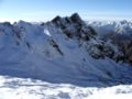
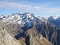
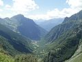
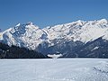
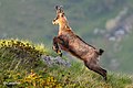
Gallery
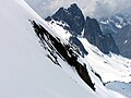
Recastello
Recastello
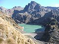
Barbellino Lake

Corna Piana

Arera

Arera

Lake Barbellino
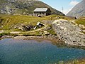
Barbellino hut

Presolana

Pizzo Coca

Presolana
Redorta

Tagliaferri hut in August

Serio Falls
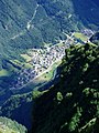
Valbondione
Valbondione, in the Park of the Bergamo Orobic Alps

Prà de'Lac


Passes

Presolana

Pizzo di Coca

Redorta

Tagliaferri hut in summer

Serio Falls

Valbondione
The main mountain passes of the Bergamasque Alps are:
| Pass | Location | Type | Elevation (m/ft) | |
|---|---|---|---|---|
| Passo di Val Morta or del Diavolo | Valle Seriana to Sondrio | footpath | 2,601 | 8,534 |
| Passo di Venina | Valle Brembana to Sondrio | footpath | 2,433 | 7,983 |
| Passo del Serio | Valle Seriana to Sondrio | footpath | 2,419 | 7937 |
| Passo del Venerocolo | Val di Scalve to Aprica | bridle path | 2,315 | 7,595 |
| Passo di Dordona | Valle Brembana to Sondrio | footpath | 2,080 | 6,824 |
| Passo San Marco | Bergamo to Morbegno | road | 1,985 | 6,513 |
| Passo del Vivione | Val di Scalve to Edolo | road | 1,819 | 5,968 |
| Passo della Presolana | Clusone to the Val di Scalve | road | 1,286 | 4,219 |
| Aprica Pass | Edolo to Sondrio | road | 1,181 | 3,875 |
| Passo di Tartano | Valleve to Tartano | footpath | 2,108 | 6,425 |
See also
- Bergamasque Prealps
References
| Wikimedia Commons has media related to Alpi Orobie (Bergamasque Alps). |
Mountain ranges of the Western Limestone Alps according to the AVE | ||
|---|---|---|
|  | |


