Alathur
Alathur | |
|---|---|
Village | |
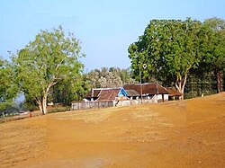 Anjumoorthy temple | |
 Alathur Location in Kerala, India Show map of Kerala  Alathur Alathur (India) Show map of India | |
| Coordinates: 10°38′53″N 76°32′18″E / 10.64806°N 76.53833°E / 10.64806; 76.53833Coordinates: 10°38′53″N 76°32′18″E / 10.64806°N 76.53833°E / 10.64806; 76.53833 | |
| Country | |
| State | Kerala |
| District | Palakkad |
| Languages | |
| • Official | Malayalam, English |
| Time zone | UTC+5:30 (IST) |
| PIN | 678541 |
| Telephone code | 04922 |
| Vehicle registration | KL-49 |
| Nearest city | Palakkad |
Lok Sabha constituency | Alathur |
Vidhan Sabha constituency | Alathur |
Alathur is a village and gram panchayat in the Palakkad District, state of Kerala, India.[1] It is the headquarters of the Alathur Taluk and is situated at the south west end of the district 24 km from the district headquarters at Palakkad. Alathur Taluk is predominantly rural and has an agricultural economy.It is located along the Coimbatore-Cochin national highway NH 47.
Contents
1 Economy
2 Educational institutions
3 Transportation
4 Healthcare
5 Panchayats in Alathur Taluk
6 Politics
7 References
8 External links
Economy
The main occupation in this area is agriculture. Rubber is grown on hilly land and rice paddies are located on the plains. Coconut, Ginger, banana, pumpkin, bitter gourd and eggplant are also grown.
There is very little industry in Alathur Taluk. Alathur town was once well known for its beedi cottage industry but production has declined due to anti-smoking efforts. Agarbatti is also produced by a cottage industry. Recently some industrial development such as steel smelting has arisen near Manjalur in Erimayur Panchayat. Historically there were a number of rice mills in the area but their numbers have declined.
Educational institutions
There are a number of schools up to the higher secondary level within Alathur Taluk. There are two colleges for arts and science, and one engineering college.
- Sree Narayana College, Alathur
- BSS B.Ed College, Alathur
A S Mohammed Kutty Sahib Memorial High Secondary School (A S M M H S S) is a public institution which has been operating in the area for over a century. The school also houses a very old Gandhiji statue which has become a landmark.
The school was establied by the Nellikkalidam Family (Swaroopm), and the School used to be called N.E. High School (NEHS), until being bought by Mr. Mohammad Kutty; later since the land reforms act, the swaroopam suffered financially and the school was bought by Mr. Mohammad Kutty, who has since then been running a Beedi rolling business
BSS Gurukulam Higher Secondary School, is also located here.
Located Taluk Hospital at Alathur town, Healthcare Professional Institution in Alathur is established by Crescent Medical Centre Ltd. The Crescent School of Nursing was started in 2001 and Crescent College of Nursing was started in 2005. The Crescent Nursing Institution runs General Nursing & Midwifery (GNM) Diploma course and BSc. Nursing Degree Course.
Transportation
The National Highway No.544 passes through the entire length of Alathur Taluk. Because of this the region is well connected by road to all parts of Kerala including the state capital. A number of private and government buses ply on this road between Trissur and Palakkad.
Alathur does not have a railway connection due to the presence of the mountainous terrain at Kuthiran towards Trissur. A recent government decision to revive an old plan to construct the Kollengode–Trissur railway line may come as a blessing to Alathur.
Healthcare
Alathur town has a Government-run Community Health Centre. The major private healthcare facility Crescent Hospital, which was established in 1997 and is a multi-speciality hospital with all basic medical departments and trauma care. That hospital also has psychiatric and geriatric facilities.
Panchayats in Alathur Taluk
- Alathur
- Erimayur
- Kannambra
- Kavasseri
- Kizhakkancheri
- Kottayi
- Kuthanur
- Kuzhalmannam
- Mathur
- Melarcode
- Peringottukurissi
- Puthucode
- Tarur
- Thenkurissi
- Vadakkencherry
- Vandazhi
Politics
The Alathur assembly constituency is part of the Alathur Lok Sabha constituency.[2]
References
^ "Reports of National Panchayat Directory". Ministry of Panchayati Raj. Archived from the original on 30 December 2013. Retrieved 2013-12-30..mw-parser-output cite.citation{font-style:inherit}.mw-parser-output .citation q{quotes:"""""""'""'"}.mw-parser-output .citation .cs1-lock-free a{background:url("//upload.wikimedia.org/wikipedia/commons/thumb/6/65/Lock-green.svg/9px-Lock-green.svg.png")no-repeat;background-position:right .1em center}.mw-parser-output .citation .cs1-lock-limited a,.mw-parser-output .citation .cs1-lock-registration a{background:url("//upload.wikimedia.org/wikipedia/commons/thumb/d/d6/Lock-gray-alt-2.svg/9px-Lock-gray-alt-2.svg.png")no-repeat;background-position:right .1em center}.mw-parser-output .citation .cs1-lock-subscription a{background:url("//upload.wikimedia.org/wikipedia/commons/thumb/a/aa/Lock-red-alt-2.svg/9px-Lock-red-alt-2.svg.png")no-repeat;background-position:right .1em center}.mw-parser-output .cs1-subscription,.mw-parser-output .cs1-registration{color:#555}.mw-parser-output .cs1-subscription span,.mw-parser-output .cs1-registration span{border-bottom:1px dotted;cursor:help}.mw-parser-output .cs1-ws-icon a{background:url("//upload.wikimedia.org/wikipedia/commons/thumb/4/4c/Wikisource-logo.svg/12px-Wikisource-logo.svg.png")no-repeat;background-position:right .1em center}.mw-parser-output code.cs1-code{color:inherit;background:inherit;border:inherit;padding:inherit}.mw-parser-output .cs1-hidden-error{display:none;font-size:100%}.mw-parser-output .cs1-visible-error{font-size:100%}.mw-parser-output .cs1-maint{display:none;color:#33aa33;margin-left:0.3em}.mw-parser-output .cs1-subscription,.mw-parser-output .cs1-registration,.mw-parser-output .cs1-format{font-size:95%}.mw-parser-output .cs1-kern-left,.mw-parser-output .cs1-kern-wl-left{padding-left:0.2em}.mw-parser-output .cs1-kern-right,.mw-parser-output .cs1-kern-wl-right{padding-right:0.2em}
^ "Assembly Constituencies – Corresponding Districts and Parliamentary Constituencies" (PDF). Kerala. Election Commission of India. Archived from the original (PDF) on 30 October 2008. Retrieved 2008-10-19.
External links
| Wikimedia Commons has media related to Alathur. |
| Wikivoyage has a travel guide for Alathur. |
- District Development Authority, Thanjavur
- Koduvayur community website. Koduvayur is 10 km west of Alathur.


