Ribeira Brava, Madeira
Ribeira Brava | |||
|---|---|---|---|
Municipality | |||
 Main centre of Ribeira Brava along the valley of the same name, and at the coast | |||
| |||
| Etymology: Portuguese for angry river | |||
 Administrative location of the municipality of Ribeira Brava in the archipelago of Madeira | |||
| Coordinates: 32°41′N 17°3′W / 32.683°N 17.050°W / 32.683; -17.050Coordinates: 32°41′N 17°3′W / 32.683°N 17.050°W / 32.683; -17.050 | |||
| Country | |||
| Autonomous Region | |||
| Island | Madeira | ||
| Settlement | c.1500 | ||
| Municipality | 6 May 1914 | ||
| Civil Parishes | Campanário, Ribeira Brava, Serra de Água, Tabua | ||
| Government | |||
| • Type | LAU | ||
| • Body | Câmara Municipal | ||
| • Mayor | Ricardo Nascimento | ||
| • Municipal Chair | João Luís Drumond Henriques | ||
| Area | |||
| • Total | 65.41 km2 (25.25 sq mi) | ||
| Population (2011) | |||
| • Total | 13,375 | ||
| • Density | 200/km2 (530/sq mi) | ||
| Time zone | UTC0 (WET) | ||
| • Summer (DST) | UTC+1 (WEST) | ||
| Postal Zone | 9350 | ||
| Area code(s) | (+351) 291 XXX-XXXX | ||
| Demonym | Ribeira-bravense | ||
| Patron Saint | São Bento | ||
| Municipal Holidays | 29 June | ||
| Website | http://www.cm-ribeirabrava.pt | ||

Ribeira Brava (Portuguese pronunciation: [ʁiˈβɐjɾɐ ˈβɾavɐ]) is a municipality on the island of Madeira, in the Portuguese Autonomous Region of Madeira. It is located along the southern coast (approximately centre), and is west of Câmara de Lobos and the regional capital Funchal, south of São Vicente, and east of Ponta do Sol. The population in 2011 was 13,375,[1] in an area of 65.41 km².[2]
The municipality gained its name due to its river - Ribeira Brava, which translates as 'the angry river'. In rainy seasons, the river had an extremely strong and powerful current, that often wreaked havoc over the entire eight kilometres of the route.
Contents
1 Geography
2 Buildings and structures
3 Gallery
4 References
Geography
The municipality's namesake, the Ribeira Brava ravine and river valley extends from the slopes of the west-central mountains
of Madeira. Its waters provide the primary sources of drinking-water (a small reservoir collects surface run-off) to the area and
electricity to the island of Madeira. Approximately ten tributaries feed this river, whose course ends in the Serra de Água and
which much later empties into the Atlantic along the village's coast.
The primary urban agglomerations are the four civil parishes, constituted with their own local government. They include:
- Campanário
- Ribeira Brava
- Serra de Água
- Tabua
Buildings and structures
The Centro Desportivo da Madeira stadium is located in the municipality.
Gallery
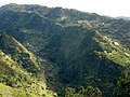
The village of Tabua over one of the tributaries of the Ribeira Brava ravine

The Ribeira Brava river, living up to its name, Angry river


References
^ Instituto Nacional de Estatística
^ Eurostat Archived September 6, 2014, at the Wayback Machine.
| Madeira Island |
| |
|---|---|---|
| Porto Santo Island |
| |


