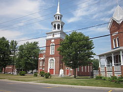
Pierreville, Quebec
Pierreville | |
|---|---|
Municipality | |
 | |
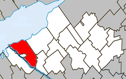
 Location within Nicolet-Yamaska RCM | |
 Pierreville Location in southern Quebec | |
| Coordinates: 46°04′N 72°49′W / 46.067°N 72.817°W / 46.067; -72.817Coordinates: 46°04′N 72°49′W / 46.067°N 72.817°W / 46.067; -72.817[1] | |
| Country | |
| Province | |
| Region | Centre-du-Québec |
| RCM | Nicolet-Yamaska |
| Constituted | June 13, 2001 |
| Government [2][3] | |
| • Mayor | André Descôteaux |
| • Federal riding | Bécancour—Nicolet—Saurel |
| • Prov. riding | Nicolet-Bécancour |
| Area [2][4] | |
| • Total | 124.90 km2 (48.22 sq mi) |
| • Land | 78.31 km2 (30.24 sq mi) |
| Population (2011)[4] | |
| • Total | 2,176 |
| • Density | 27.8/km2 (72/sq mi) |
| • Pop 2006–2011 | |
| • Dwellings | 1,152 |
| Time zone | UTC−5 (EST) |
| • Summer (DST) | UTC−4 (EDT) |
| Postal code(s) | J0G 1J0 |
| Area code(s) | 450 and 579 |
| Highways | |
| Website | www.pierreville.net |
Pierreville is a municipality in Nicolet-Yamaska Regional County Municipality, Quebec, located at the confluence of the Saint Lawrence and Saint-François rivers, at the edge of Lac Saint-Pierre. The population as of the Canada 2011 Census was 2,176.
Pierreville faces the town of Saint-François-du-Lac across the Saint-François river, and lies at the junction of Route 132 and Route 226. Part of the Abenaki Indian reserve of Odanak is an enclave within the city limits of Pierreville. The limits of the reserve begin only a short walk away from the town's main street.
Contents
1 History
2 Demographics
2.1 Population
2.2 Language
3 Economy
3.1 Manufacturing
3.2 Agriculture
4 Climate
5 See also
6 References
7 External links
History
On 21 August 1991, an F3 tornado, the "tornade de Maskinongé", touched down in Notre-Dame-de-Pierreville (today part of Pierreville), destroying a number of summer homes in the area and injuring 15 people.[5]
On June 13, 2001, the parish municipalities of Notre-Dame-de-Pierreville and Saint-Thomas-de-Pierreville merged with the village municipality of Pierreville to form the new municipality of Pierreville.[6]
Demographics
|
| Census | Population | Change (%) |
|---|---|---|
| 2011 | 2,176 | |
| 2006 | 2,337 | |
| Merger (+) | 2,402 | |
| 2001 | 950 | |
| Boundary change | 1,055 | |
| 1996 | 976 | |
| 1991 | 1,074 | N/A |
(+) Amalgamation of the Parishes of Notre-Dame-de-Pierreville, Saint-Thomas-de-Pierreville, and the Village of Pierreville on June 13, 2001.
Language
Mother tongue language (2006)[8]
| Language | Population | Pct (%) |
|---|---|---|
| French only | 2,235 | 97.60% |
| English only | 10 | 0.44% |
| Both English and French | 0 | 0.00% |
| Other languages | 45 | 1.96% |
Economy
Manufacturing
Pierreville is a major centre for the manufacture of fire trucks. Local builder Pierre Thibault Canada Ltee. built fire apparatus in Pierreville from 1938 to 1990. In 1968, members of the Thibault family established a competing business, Pierreville Fire Trucks, across the river in Saint-François-du-Lac. It operated until 1985. Levasseur Fire Trucks also built fire apparatus in Saint-François-du-Lac from 1988 to 2014. Today, Carl Thibault Fire Trucks operates in the former Pierre Thibault facility in Pierreville.[9]
During the visit of Pope John Paul II to Canada in 1984, Pierre Thibault modified a GMC Sierra truck for use as a Popemobile, a secure form of transport built to withstand a commando attack. It was subsequently used for the 1998 papal visit to Cuba and was displayed at the Canada Museum of Science and Technology in 2005. The second truck was sent back to the Vatican in 1984.[10][11][12]
Agriculture
Like the rest of the Centre-du-Quebec region, agriculture plays an important role in Pierreville's economy, with a number of dairy, vegetable, grain and other farms based in the area.
Climate
| Climate data for Pierreville | |||||||||||||
|---|---|---|---|---|---|---|---|---|---|---|---|---|---|
| Month | Jan | Feb | Mar | Apr | May | Jun | Jul | Aug | Sep | Oct | Nov | Dec | Year |
| Record high °C (°F) | 14.5 (58.1) | 11.5 (52.7) | 16.5 (61.7) | 31.5 (88.7) | 31 (88) | 34 (93) | 34 (93) | 33.5 (92.3) | 31.5 (88.7) | 25.5 (77.9) | 21 (70) | 14.5 (58.1) | 34 (93) |
| Average high °C (°F) | −6.5 (20.3) | −4.1 (24.6) | 1.4 (34.5) | 10.3 (50.5) | 18.7 (65.7) | 23.6 (74.5) | 25.8 (78.4) | 24.6 (76.3) | 19.3 (66.7) | 12.3 (54.1) | 4.3 (39.7) | −2.9 (26.8) | 10.6 (51.1) |
| Daily mean °C (°F) | −11.6 (11.1) | −9.3 (15.3) | −3.5 (25.7) | 5.4 (41.7) | 12.9 (55.2) | 18 (64) | 20.3 (68.5) | 19.1 (66.4) | 14.2 (57.6) | 7.8 (46.0) | 0.8 (33.4) | −7.2 (19.0) | 5.6 (42.1) |
| Average low °C (°F) | −16.6 (2.1) | −14.4 (6.1) | −8.3 (17.1) | 0.5 (32.9) | 7.2 (45.0) | 12.4 (54.3) | 14.7 (58.5) | 13.7 (56.7) | 9 (48) | 3.3 (37.9) | −2.8 (27.0) | −11.4 (11.5) | 0.6 (33.1) |
| Record low °C (°F) | −38 (−36) | −34 (−29) | −32 (−26) | −15 (5) | −3 (27) | 0 (32) | 4.5 (40.1) | 2 (36) | −3 (27) | −7 (19) | −20 (−4) | −37.5 (−35.5) | −38 (−36) |
| Average precipitation mm (inches) | 76.7 (3.02) | 57 (2.2) | 64.8 (2.55) | 73.5 (2.89) | 87.1 (3.43) | 91.1 (3.59) | 97.4 (3.83) | 94.7 (3.73) | 79.2 (3.12) | 81 (3.2) | 95.4 (3.76) | 69.5 (2.74) | 967.5 (38.09) |
| Source: Environment Canada[13] | |||||||||||||
See also
- List of municipalities in Quebec
- Municipal history of Quebec
References
^ Reference number 289198 of the Commission de toponymie du Québec (in French)
^ ab "Pierreville - Répertoire des municipalités - Ministère des Affaires municipales et de l'Occupation du territoire". mamrot.gouv.qc.ca. Retrieved 2015-02-20..mw-parser-output cite.citation{font-style:inherit}.mw-parser-output .citation q{quotes:"""""""'""'"}.mw-parser-output .citation .cs1-lock-free a{background:url("//upload.wikimedia.org/wikipedia/commons/thumb/6/65/Lock-green.svg/9px-Lock-green.svg.png")no-repeat;background-position:right .1em center}.mw-parser-output .citation .cs1-lock-limited a,.mw-parser-output .citation .cs1-lock-registration a{background:url("//upload.wikimedia.org/wikipedia/commons/thumb/d/d6/Lock-gray-alt-2.svg/9px-Lock-gray-alt-2.svg.png")no-repeat;background-position:right .1em center}.mw-parser-output .citation .cs1-lock-subscription a{background:url("//upload.wikimedia.org/wikipedia/commons/thumb/a/aa/Lock-red-alt-2.svg/9px-Lock-red-alt-2.svg.png")no-repeat;background-position:right .1em center}.mw-parser-output .cs1-subscription,.mw-parser-output .cs1-registration{color:#555}.mw-parser-output .cs1-subscription span,.mw-parser-output .cs1-registration span{border-bottom:1px dotted;cursor:help}.mw-parser-output .cs1-ws-icon a{background:url("//upload.wikimedia.org/wikipedia/commons/thumb/4/4c/Wikisource-logo.svg/12px-Wikisource-logo.svg.png")no-repeat;background-position:right .1em center}.mw-parser-output code.cs1-code{color:inherit;background:inherit;border:inherit;padding:inherit}.mw-parser-output .cs1-hidden-error{display:none;font-size:100%}.mw-parser-output .cs1-visible-error{font-size:100%}.mw-parser-output .cs1-maint{display:none;color:#33aa33;margin-left:0.3em}.mw-parser-output .cs1-subscription,.mw-parser-output .cs1-registration,.mw-parser-output .cs1-format{font-size:95%}.mw-parser-output .cs1-kern-left,.mw-parser-output .cs1-kern-wl-left{padding-left:0.2em}.mw-parser-output .cs1-kern-right,.mw-parser-output .cs1-kern-wl-right{padding-right:0.2em}
^ "Parliament of Canada Federal Riding History: BAS-RICHELIEU--NICOLET--BÉCANCOUR (Quebec)". www2.parl.gc.ca. Retrieved 2015-02-20.
^ ab "2011 Statistics Canada Census Profile: Pierreville, Quebec". www12.statcan.gc.ca. Retrieved 2015-02-20.
^ "Principales tornades au Canada, section Fleuve Saint-Laurent-1991". Atlas du Canada (in French). Ressources naturelles Canada. 5 March 2009. Archived from the original on 11 June 2008. Retrieved 2010-07-22.
^ "Fiche descriptive". toponymie.gouv.qc.ca. Retrieved 2015-02-20.
^ Statistics Canada: 1996, 2001, 2006, 2011 census
^ "Community Profiles from the 2006 Census, Statistics Canada - Census Subdivision". www12.statcan.gc.ca. Retrieved 2015-02-20.
^ Omnimedia. "History - Carl Thibault Fire Trucks - Emergency vehicles". thibaultfiretrucks.com. Retrieved 2015-02-20.
^ 'Popemobile' Plush, Impervious Thibault Fire Engines
^ Canadian Popemobile going on display CBC News, April 7, 2005
^ Kearney, M.; Ray, R. (2006). Whatever Happened To-- ?: Catching Up with Canadian Icons. Dundurn. p. 98. ISBN 9781550026542. Retrieved 2015-02-20.
^ Environment Canada
Canadian Climate Normals 1971–2000, accessed 2010-07-23.
External links
 Media related to Pierreville, Quebec at Wikimedia Commons