Poltava Oblast
Poltava Oblast Полтавська область Poltavs’ka oblast’ | |||
|---|---|---|---|
Oblast | |||
| |||
| Nickname(s): Полтавщина (Poltavshchyna) | |||
 | |||
| Country | |||
| Administrative center | Poltava | ||
| Government | |||
| • Governor | Valeriy Holovko (Batkivshchyna) | ||
| • Oblast council | 84 seats | ||
| Area | |||
| • Total | 28,748 km2 (11,100 sq mi) | ||
| Area rank | Ranked 6th | ||
| Population (2015) | |||
| • Total | 1,438,948 | ||
| • Rank | Ranked 12th | ||
| • Density | 50/km2 (130/sq mi) | ||
| Time zone | UTC+2 (EET) | ||
| • Summer (DST) | UTC+3 (EEST) | ||
| Postal code | 36000-38999 | ||
| Area code | +380-53 | ||
| ISO 3166 code | UA-53 | ||
| Raions | 25 | ||
Cities (total) | 15 | ||
| • Regional cities | 5 | ||
| Urban-type settlements | 21 | ||
| Villages | 1831 | ||
| FIPS 10-4 | UP18 | ||
| Website | www.oblrada.pl.ua/ | ||


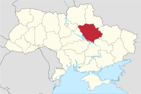
Poltava Oblast (Ukrainian: Полтавська область, translit. Poltavs’ka oblast’; also referred to as Poltavshchyna – Ukrainian: Полтавщина) is an oblast (province) of central Ukraine. The administrative center of the oblast is the city of Poltava. Most of its territory is part of the historic Cossack Hetmanate (its southern regions: Poltava, Myrhorod, Lubny, and Hadiach). Population: 1,438,948 (2015 est.)[1]
Two other important cities there are Horishni Plavni and Kremenchuk.
Contents
1 Geography
2 Points of interest
3 Demographics
3.1 Age structure
3.2 Median age
4 Economy
4.1 Industry
4.2 Agriculture
5 Administrative divisions
6 Nomenclature
7 References
8 External links
Geography
Poltava Oblast is situated in the central part of Ukraine. Located on the left bank of Dnieper, Poltava region was part of the Cossack Hetmanate. It has an area of 28,800 km². The oblast borders upon Chernihiv, Sumy, Kharkiv, Dnipropetrovsk, Kirovohrad, Cherkasy and Kyiv regions.
Points of interest
The following historic-cultural sites were nominated for the Seven Wonders of Ukraine.
- Gogol preserve-museum
- Kotliarevsky villa
- Mykolaivska Church
- Poltava ethnical museum
- Cross-Erecting monastery
Demographics
At 2005-05-01, its population was 1,584,446, and population density was 59 people per 1 km².
Age structure
0-14 years: 13.2% (male 99,444/female 93,949)
15-64 years: 69.9% (male 483,389/female 530,911)
65 years and over: 16.9% (male 81,435/female 164,861) (2013 official)
Median age
total: 41.4 years
male: 38.0 years
female: 44.7 years (2013 official)
Economy
Industry
The oblast’ is a center of Ukraine's oil and natural gas industry, with many wells and pipelines situated here. There is a major oil refinery plant in the city of Kremenchuk. Important iron ore processing facilities also present. In general there are 374 large industrial organization and 618 small industrial organizations.
Agriculture
In 1999 the gross grain yield was about 1452,9 thousand tons, sugar beets – 1002,900 tons, sunflower seeds – 166,200 tons, potatoes – 279,900 tons. The oblast also produced 120,500 tons of meat, 645,900 tons of milk and 423,200,00 eggs. At the beginning of 1999 there were 1,311 registered farms in the region.
Administrative divisions
The oblast is divided into 25 districts, 5 cities, 21 urban villages, and 1862 villages.
The following data incorporates the number of each type of administrative divisions of the Poltava Oblast’:
- Administrative Center – 1 (Poltava)
Raions — 25;- City raions — 5;
- Settlements — 1526, including:
Villages — 1,831;- Cities/Towns — 35, including:
Urban-type settlement — 21;- Cities — 15, including:
- Cities of oblast' subordinance — 5;
- Cities of raion subordinance — 8;
Rural councils — 384.
The local administration of the oblast' is controlled by the Poltava Oblast Rada. The governor of the oblast’ is the Poltava Oblast’ Rada speaker, appointed by the President of Ukraine.
| Name | Ukrainian Name | Area (km2) | Population census 2015[2] | Admin.center | Urban Population Only |
|---|---|---|---|---|---|
| Poltava | Полта́ва (місто) | 103 | 293,945 | Poltava (city) | 293,945 |
| Horishni Plavni | Горішні Плавні (місто) | 34 | 54,701 | Horishni Plavni (town) | 52,144 |
| Kremenchuk | Кременчу́к (місто) | 96 | 223,942 | Kremenchuk (city) | 223,942 |
| Lubny | Лубни (місто) | 46 | 46,820 | Lubny (city) | 46,820 |
| Myrhorod | Миргород (місто) | 20 | 40,440 | Myrhorod (city) | 40,440 |
| Chornukhy Raion | Чорнухинський район | 682 | 11,485 | Chornukhy | 2,581 |
| Chutove Raion | Чутівський район | 861 | 22,976 | Chutove | 9,468 |
| Dykanka Raion | Диканський район | 679 | 18,993 | Dykanka | 7,804 |
| Hadiach Raion | Гадяцький район | 1,595 | 29,767 | Hadiach | 24,005 |
| Hlobyne Raion | Глобинський район | 2,500 | 44,007 | Hlobyne | 16,182 |
| Hrebinka Raion | Гребінківський район | 595 | 22,589 | Hrebinka | 10,926 |
| Karlivka Raion | Карлівський район | 854 | 34,121 | Karlivka | 14,997 |
| Khorol Raion | Хорольський район | 1,062 | 34,670 | Khorol | 13,304 |
| Kobeliaky Raion | Кобеляцький район | 1,823 | 42,419 | Kobeliaky | 14,982 |
| Kotelva Raion | Котелевський район | 800 | 19,674 | Kotelva | 12,406 |
| Kozelshchyna Raion | Козельщинський район | 930 | 19,575 | Kozelshchyna | 5,981 |
| Kremenchuk Raion | Кременчуцький район | 1,200 | 39,699 | Kremenchuk (city) | N/A * |
| Lokhvytsia Raion | Лохвицький район | 1,300 | 43,274 | Lokhvytsia | 20,187 |
| Lubny Raion | Лубенський район | 1,378 | 31,983 | Lubny (city) | N/A * |
| Mashivka Raion | Машівський район | 889 | 19,609 | Mashivka | 3,815 |
| Myrhorod Raion | Миргородський район | 1,540 | 32,115 | Myrhorod (city) | N/A * |
| Novi Sanzhary Raion | Новосанжарський район | 1,300 | 34,620 | Novi Sanzhary | 8,375 |
| Orzhytsia Raion | Оржицький район | 1,000 | 24228 | Orzhytsia | 5,369 |
| Poltava Raion | Полтавський район | 1,259 | 67,095 | Poltava (city) | N/A * |
| Pyriatyn Raion | Пирятинський район | 864 | 31,809 | Pyriatyn | 15,796 |
| Reshetylivka Raion | Решетилівський район | 1,009 | 26,399 | Reshetylivka | 9,340 |
| Semenivka Raion | Семенівський район | 1,300 | 25,456 | Semenivka | 6,244 |
| Shyshaky Raion | Шишацький район | 790 | 20,423 | Shyshaky | 4,545 |
| Velyka Bahachka Raion | Великобагачанський район | 1,000 | 25,145 | Velyka Bahachka | 8,350 |
| Zinkiv Raion | Зіньківський район | 1,360 | 34,700 | Zinkiv | 15,179 |
Note: Asterisks (*) Though the administrative center of the rayon is housed in the city/town that its named after, cities do not answer to the rayon authorities only towns do; instead they are directly subordinated to the oblast government and therefore are not counted as part of rayon statistics.
Nomenclature
Most of Ukraine's oblasts are named after their capital cities, officially referred to as "oblast centers" (Ukrainian: обласний центр, translit. oblasnyi tsentr). The name of each oblast is a relative adjective, formed by adding a feminine suffix to the name of respective center city: Poltava is the center of the Poltavs’ka oblast’ (Poltava Oblast). Most oblasts are also sometimes referred to in a feminine noun form, following the convention of traditional regional place names, ending with the suffix "-shchyna", as is the case with the Poltava Oblast, Poltavshchyna.
References
^ "Чисельність наявного населення України (Actual population of Ukraine)" (PDF) (in Ukrainian). State Statistics Service of Ukraine. Retrieved 1 July 2016..mw-parser-output cite.citation{font-style:inherit}.mw-parser-output .citation q{quotes:"""""""'""'"}.mw-parser-output .citation .cs1-lock-free a{background:url("//upload.wikimedia.org/wikipedia/commons/thumb/6/65/Lock-green.svg/9px-Lock-green.svg.png")no-repeat;background-position:right .1em center}.mw-parser-output .citation .cs1-lock-limited a,.mw-parser-output .citation .cs1-lock-registration a{background:url("//upload.wikimedia.org/wikipedia/commons/thumb/d/d6/Lock-gray-alt-2.svg/9px-Lock-gray-alt-2.svg.png")no-repeat;background-position:right .1em center}.mw-parser-output .citation .cs1-lock-subscription a{background:url("//upload.wikimedia.org/wikipedia/commons/thumb/a/aa/Lock-red-alt-2.svg/9px-Lock-red-alt-2.svg.png")no-repeat;background-position:right .1em center}.mw-parser-output .cs1-subscription,.mw-parser-output .cs1-registration{color:#555}.mw-parser-output .cs1-subscription span,.mw-parser-output .cs1-registration span{border-bottom:1px dotted;cursor:help}.mw-parser-output .cs1-ws-icon a{background:url("//upload.wikimedia.org/wikipedia/commons/thumb/4/4c/Wikisource-logo.svg/12px-Wikisource-logo.svg.png")no-repeat;background-position:right .1em center}.mw-parser-output code.cs1-code{color:inherit;background:inherit;border:inherit;padding:inherit}.mw-parser-output .cs1-hidden-error{display:none;font-size:100%}.mw-parser-output .cs1-visible-error{font-size:100%}.mw-parser-output .cs1-maint{display:none;color:#33aa33;margin-left:0.3em}.mw-parser-output .cs1-subscription,.mw-parser-output .cs1-registration,.mw-parser-output .cs1-format{font-size:95%}.mw-parser-output .cs1-kern-left,.mw-parser-output .cs1-kern-wl-left{padding-left:0.2em}.mw-parser-output .cs1-kern-right,.mw-parser-output .cs1-kern-wl-right{padding-right:0.2em}
^ "Population Quantity". UkrStat (in Ukrainian). Retrieved 15 January 2016.
External links
State Administration of Poltava Region – official site (in Ukrainian)
Information Card of the Region – official site of the Cabinet of Ministers of Ukraine
Administrative center: Poltava | |||||
| Raions |
| ||||
| Cities |
| ||||
| |||||
Capital: Kiev | |
| Oblasts |
|
| Cities with special status |
|
| Autonomous republic |
|
| Administrative centers |
|
1Claimed and controlled by Russia as the Republic of Crimea and the Federal City of Sevastopol 2Regions are nearly controlled by Pro-Russian seperatists states of Donetsk People's Republic and Luhansk People's Republic | |
Places adjacent to Poltava Oblast | ||||||||||
|---|---|---|---|---|---|---|---|---|---|---|
| ||||||||||
Coordinates: 49°30′N 34°00′E / 49.500°N 34.000°E / 49.500; 34.000
Authority control |
|
|---|