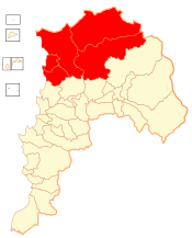
Petorca Province
Petorca Province Provincia de Petorca | ||
|---|---|---|
Province | ||
| ||
 Location in the Valparaíso Region | ||
 Petorca Province Location in Chile | ||
| Coordinates: 32°22′S 71°06′W / 32.367°S 71.100°W / -32.367; -71.100Coordinates: 32°22′S 71°06′W / 32.367°S 71.100°W / -32.367; -71.100 | ||
| Country | ||
| Region | ||
| Capital | La Ligua | |
| Communes | List of 5:
| |
| Government | ||
| • Type | Provincial | |
| • Governor | María Paz Santilices Cañas (UDI) | |
| Area [1] | ||
| • Total | 4,588.9 km2 (1,771.8 sq mi) | |
| Area rank | 1 | |
| Population (2012 Census)[1] | ||
| • Total | 72,286 | |
| • Rank | 7 | |
| • Density | 16/km2 (41/sq mi) | |
| • Urban | 50,289 | |
| • Rural | 20,321 | |
| Sex [1] | ||
| • Men | 35,647 | |
| • Women | 34,963 | |
| Time zone | UTC-4 (CLT [2]) | |
| • Summer (DST) | UTC-3 (CLST [3]) | |
| Area code(s) | 56 + | |
| Website | Governorate of Petorca | |
Petorca Province (Spanish: Provincia de Petorca) is one of eight provinces of the central Chilean region of Valparaíso (V). Its capital is the city of La Ligua.
Contents
1 Administration
1.1 Communes
2 Geography and demography
3 References
4 External links
Administration
As a province, Petorca is a second-level administrative division, governed by a provincial governor who is appointed by the president.
Communes
The province comprises five communes (Spanish: comunas), each governed by a municipality consisting of an alcalde and municipal council:
- La Ligua
- Cabildo
- Zapallar
- Papudo
- Petorca
Geography and demography
The province spans an area of 4,588.9 km2 (1,772 sq mi), the largest in the Valparaíso Region. According to the 2002 census, Petorca is the second least populous province in the region under Isla de Pascua (Easter Island) with a population of 70,610. At that time, there were 50,289 people living in urban areas, 20,321 people living in rural areas, 35,647 men and 34,963 women.[1]
References
^ abcd (in Spanish) Instituto Nacional de Estadísticas
^ "Chile Time". WorldTimeZones.org. Archived from the original on 2010-07-13. Retrieved 2010-07-28..mw-parser-output cite.citation{font-style:inherit}.mw-parser-output .citation q{quotes:"""""""'""'"}.mw-parser-output .citation .cs1-lock-free a{background:url("//upload.wikimedia.org/wikipedia/commons/thumb/6/65/Lock-green.svg/9px-Lock-green.svg.png")no-repeat;background-position:right .1em center}.mw-parser-output .citation .cs1-lock-limited a,.mw-parser-output .citation .cs1-lock-registration a{background:url("//upload.wikimedia.org/wikipedia/commons/thumb/d/d6/Lock-gray-alt-2.svg/9px-Lock-gray-alt-2.svg.png")no-repeat;background-position:right .1em center}.mw-parser-output .citation .cs1-lock-subscription a{background:url("//upload.wikimedia.org/wikipedia/commons/thumb/a/aa/Lock-red-alt-2.svg/9px-Lock-red-alt-2.svg.png")no-repeat;background-position:right .1em center}.mw-parser-output .cs1-subscription,.mw-parser-output .cs1-registration{color:#555}.mw-parser-output .cs1-subscription span,.mw-parser-output .cs1-registration span{border-bottom:1px dotted;cursor:help}.mw-parser-output .cs1-ws-icon a{background:url("//upload.wikimedia.org/wikipedia/commons/thumb/4/4c/Wikisource-logo.svg/12px-Wikisource-logo.svg.png")no-repeat;background-position:right .1em center}.mw-parser-output code.cs1-code{color:inherit;background:inherit;border:inherit;padding:inherit}.mw-parser-output .cs1-hidden-error{display:none;font-size:100%}.mw-parser-output .cs1-visible-error{font-size:100%}.mw-parser-output .cs1-maint{display:none;color:#33aa33;margin-left:0.3em}.mw-parser-output .cs1-subscription,.mw-parser-output .cs1-registration,.mw-parser-output .cs1-format{font-size:95%}.mw-parser-output .cs1-kern-left,.mw-parser-output .cs1-kern-wl-left{padding-left:0.2em}.mw-parser-output .cs1-kern-right,.mw-parser-output .cs1-kern-wl-right{padding-right:0.2em}
^ "Chile Summer Time". WorldTimeZones.org. Archived from the original on 2007-09-11. Retrieved 2010-07-28.
External links
- Official link

