Garibaldi Provincial Park
| Garibaldi Provincial Park | |
|---|---|
IUCN category II (national park) | |
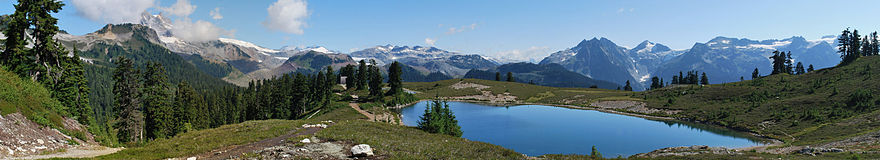
 Garibaldi Lake and the Battleship Islands | |
| Location | British Columbia, Canada |
| Nearest city | Squamish & Whistler, British Columbia |
| Coordinates | 49°55′N 122°45′W / 49.917°N 122.750°W / 49.917; -122.750Coordinates: 49°55′N 122°45′W / 49.917°N 122.750°W / 49.917; -122.750 |
| Area | 1,950 km2 (750 sq mi) |
| Established | 1927 |
| Governing body | BC Parks |
Garibaldi Provincial Park, also called Garibaldi Park, is a wilderness park located in British Columbia, Canada, about 70 kilometres (43.5 mi) north of Vancouver. The park is located to the east of the Sea to Sky Highway between Squamish and Whistler and covers an area of over 1,950 square kilometres (753 sq mi). Garibaldi was designated as a provincial park in 1927, and originally included what was later split off in 1967 as Golden Ears Provincial Park,[1] which juts southward between the basins of Pitt Lake and the Stave River into the Municipality of Maple Ridge.
Contents
1 Region
2 Wildlife
3 Recreational access
4 See also
5 References
6 External links
Region

Cheakamus Lake at dawn
The park consists of many steep, rugged mountains, many of them capped by glaciers. It includes Mount Garibaldi and other volcanoes related to subduction volcanism in the Garibaldi Volcanic Belt. The park features many dense Douglas-fir, western red cedar and western-hemlock forests, as well as alpine meadows and many rocky alpine areas. The park reaches its highest peak at Wedge Mountain—2,891 metres (9,485 ft).
Wildlife
This park is home to mammalian species including black bear, mountain goat, deer, marmot, and pika. Bird species of golden eagle, bald eagle, and ptarmagin also inhabit the area.
Recreational access
There are five park access and entrance points located along the Sea to Sky Highway. Each entrance provides access to hiking trails with backcountry camping opportunities. All access points are open in winter for backcountry skiing, but only the Diamond Head access road is plowed. All camp sites are first-come, first-served.
Diamond Head
This southern most entrance provides hiking or skiing access to the area south of Mount Garibaldi. A cooking hut and winter-only camping area are located in Red Heather Meadows, about 5 kilometres (3 mi) from the parking lot. An overnight shelter and campground are located 12 kilometres (7.5 mi) from the parking lot at Elfin Lakes.
The Black Tusk/Garibaldi Lake
The second entrance is located approximately halfway between Squamish and Whistler. Hiking trails provide access to Garibaldi Lake, The Black Tusk, and Panorama Ridge. A trail also connects to the Cheakamus Lake area further north. Two camping areas provide sites for 90 tents.

Wedgemount Lake with Whistler Mountain visible in the top right corner.
Cheakamus Lake
This entrance, located just to the south of Whistler, provides access to Cheakamus Lake. Two campgrounds are located a few kilometers from the parking lot.
Singing Pass
The Singing Pass area is located to the east of Whistler Mountain. The area can be accessed by a trail which follows the Fitzsimmons Creek, between Whistler and Blackcomb mountains. The area can also be accessed from the top of Whistler mountain via an alpine route. Camping is permitted at Russet Lake.
Wedgemount Lake
The most northern entrance is via a deactivated forest service road. The road is unmaintained and is recommended for 4x4 vehicles only. Wedgemount Lake is accessed via a hiking trail. Camping is permitted around the lake.
See also
- The Black Tusk
- Golden Ears Provincial Park
References
^ "Golden Ears Park". BC Geographical Names..mw-parser-output cite.citation{font-style:inherit}.mw-parser-output .citation q{quotes:"""""""'""'"}.mw-parser-output .citation .cs1-lock-free a{background:url("//upload.wikimedia.org/wikipedia/commons/thumb/6/65/Lock-green.svg/9px-Lock-green.svg.png")no-repeat;background-position:right .1em center}.mw-parser-output .citation .cs1-lock-limited a,.mw-parser-output .citation .cs1-lock-registration a{background:url("//upload.wikimedia.org/wikipedia/commons/thumb/d/d6/Lock-gray-alt-2.svg/9px-Lock-gray-alt-2.svg.png")no-repeat;background-position:right .1em center}.mw-parser-output .citation .cs1-lock-subscription a{background:url("//upload.wikimedia.org/wikipedia/commons/thumb/a/aa/Lock-red-alt-2.svg/9px-Lock-red-alt-2.svg.png")no-repeat;background-position:right .1em center}.mw-parser-output .cs1-subscription,.mw-parser-output .cs1-registration{color:#555}.mw-parser-output .cs1-subscription span,.mw-parser-output .cs1-registration span{border-bottom:1px dotted;cursor:help}.mw-parser-output .cs1-ws-icon a{background:url("//upload.wikimedia.org/wikipedia/commons/thumb/4/4c/Wikisource-logo.svg/12px-Wikisource-logo.svg.png")no-repeat;background-position:right .1em center}.mw-parser-output code.cs1-code{color:inherit;background:inherit;border:inherit;padding:inherit}.mw-parser-output .cs1-hidden-error{display:none;font-size:100%}.mw-parser-output .cs1-visible-error{font-size:100%}.mw-parser-output .cs1-maint{display:none;color:#33aa33;margin-left:0.3em}.mw-parser-output .cs1-subscription,.mw-parser-output .cs1-registration,.mw-parser-output .cs1-format{font-size:95%}.mw-parser-output .cs1-kern-left,.mw-parser-output .cs1-kern-wl-left{padding-left:0.2em}.mw-parser-output .cs1-kern-right,.mw-parser-output .cs1-kern-wl-right{padding-right:0.2em}
External links
Wikimedia Commons has media related to: Garibaldi Provincial Park (category) |
| Wikivoyage has a travel guide for Garibaldi Provincial Park. |
- BCParks - Garibaldi page
- - UN database entry
- - History of Park and Area - Virtual Museum of Canada
- - Garibaldi Park 2020 - History of Park and Mapping
.mw-parser-output .navbox-canada .navbox-title,.mw-parser-output .navbox-canada th,.mw-parser-output .navbox-canada .navbox-group,.mw-parser-output .navbox-canada .navbox-abovebelow,.mw-parser-output .navbox-canada .navbox-subgroup,.mw-parser-output .navbox-canada .navbox-odd,.mw-parser-output .navbox-canada .navbox-even{background-color:white}.mw-parser-output .navbox-canada .navbox-list .collapsible .navbox-title{box-shadow:inset 1px 1px 0 #C00,inset -1px -1px 0 #C00}.mw-parser-output .navbox-canada-a{box-shadow:inset 1px 1px 0 #C00,inset -1px -1px 0 #C00}.mw-parser-output .navbox-canada-t{box-shadow:inset 0 1px 0 0 #C00}.mw-parser-output .navbox-canada-b{box-shadow:inset 0 -1px 0 0 #C00}.mw-parser-output .navbox-canada-tb{box-shadow:inset 0 1px 0 0 #C00,inset 0 -1px 0 0 #C00} | |
|---|---|
| Ranges |
|
| Mountains |
|
| Passes |
|
| Glaciers |
|
| Communities |
|
| Parks |
|
Protected areas of British Columbia | |||||||||||||||||||||||||||||||
|---|---|---|---|---|---|---|---|---|---|---|---|---|---|---|---|---|---|---|---|---|---|---|---|---|---|---|---|---|---|---|---|
| |||||||||||||||||||||||||||||||
| |||||||||||||||||||||||||||||||
| |||||||||||||||||||||||||||||||
| |||||||||||||||||||||||||||||||
| |||||||||||||||||||||||||||||||
| |||||||||||||||||||||||||||||||
| |||||||||||||||||||||||||||||||


