Khorramshahr County
Khorramshahr County شهرستان خرمشهر | |
|---|---|
| County | |
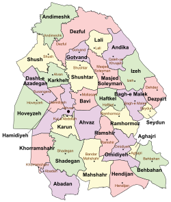 Counties of Khuzestan Province | |
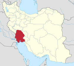 Location of Khuzestan Province in Iran | |
| Coordinates: 30°35′N 48°10′E / 30.583°N 48.167°E / 30.583; 48.167Coordinates: 30°35′N 48°10′E / 30.583°N 48.167°E / 30.583; 48.167 | |
| Country | |
| Province | Khuzestan |
| Capital | Khorramshahr |
Bakhsh (Districts) | Central District, Minu District |
| Population (2016) | |
| • Total | 170,976 |
| Time zone | UTC+3:30 (IRST) |
| • Summer (DST) | UTC+4:30 (IRDT) |
| Khorramshahr County can be found at GEOnet Names Server, at this link, by opening the Advanced Search box, entering "9206387" in the "Unique Feature Id" form, and clicking on "Search Database". | |
Khorramshahr County ([xoræmˈʃæhɾ], Persian: شهرستان خرمشهر) is a county in Khuzestan Province in Iran. The capital of the county is Khorramshahr. At the 2006 census, the county's population was 155,224, in 32,563 families.[1] The county is subdivided into two districts: the Central District and Minu District. The county has three cities: Khorramshahr, Moqavemat, and Minushahr.
References
^ "Census of the Islamic Republic of Iran, 1385 (2006)". Islamic Republic of Iran. Archived from the original (Excel) on 2011-11-11..mw-parser-output cite.citation{font-style:inherit}.mw-parser-output q{quotes:"""""""'""'"}.mw-parser-output code.cs1-code{color:inherit;background:inherit;border:inherit;padding:inherit}.mw-parser-output .cs1-lock-free a{background:url("//upload.wikimedia.org/wikipedia/commons/thumb/6/65/Lock-green.svg/9px-Lock-green.svg.png")no-repeat;background-position:right .1em center}.mw-parser-output .cs1-lock-limited a,.mw-parser-output .cs1-lock-registration a{background:url("//upload.wikimedia.org/wikipedia/commons/thumb/d/d6/Lock-gray-alt-2.svg/9px-Lock-gray-alt-2.svg.png")no-repeat;background-position:right .1em center}.mw-parser-output .cs1-lock-subscription a{background:url("//upload.wikimedia.org/wikipedia/commons/thumb/a/aa/Lock-red-alt-2.svg/9px-Lock-red-alt-2.svg.png")no-repeat;background-position:right .1em center}.mw-parser-output .cs1-subscription,.mw-parser-output .cs1-registration{color:#555}.mw-parser-output .cs1-subscription span,.mw-parser-output .cs1-registration span{border-bottom:1px dotted;cursor:help}.mw-parser-output .cs1-hidden-error{display:none;font-size:100%}.mw-parser-output .cs1-visible-error{font-size:100%}.mw-parser-output .cs1-subscription,.mw-parser-output .cs1-registration,.mw-parser-output .cs1-format{font-size:95%}.mw-parser-output .cs1-kern-left,.mw-parser-output .cs1-kern-wl-left{padding-left:0.2em}.mw-parser-output .cs1-kern-right,.mw-parser-output .cs1-kern-wl-right{padding-right:0.2em}
- اطلس گیتاشناسی استانهای ایران [Atlas Gitashenasi Ostanhai Iran] (Gitashenasi Province Atlas of Iran)
| Capital |
|  | |||||||||||||||||||||||||||||||||||||||||||||||||||
|---|---|---|---|---|---|---|---|---|---|---|---|---|---|---|---|---|---|---|---|---|---|---|---|---|---|---|---|---|---|---|---|---|---|---|---|---|---|---|---|---|---|---|---|---|---|---|---|---|---|---|---|---|---|
Counties and cities |
| ||||||||||||||||||||||||||||||||||||||||||||||||||||
| Sights |
| ||||||||||||||||||||||||||||||||||||||||||||||||||||
| populated places |
| ||||||||||||||||||||||||||||||||||||||||||||||||||||
| Capital |
| ||||||||||||||||||||
|---|---|---|---|---|---|---|---|---|---|---|---|---|---|---|---|---|---|---|---|---|---|
| Districts |
| ||||||||||||||||||||
This Khorramshahr County location article is a stub. You can help Wikipedia by expanding it. |


