Lower Merion Township, Pennsylvania
Lower Merion Lower Merion Township | |||
|---|---|---|---|
| Township | |||
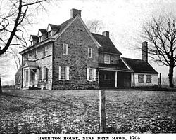 Harriton House as it appeared ca. 1919. | |||
| |||
| Motto(s): "A First-Class Township" | |||
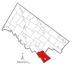 Location of Lower Merion Township in Montgomery County | |||
 Lower Merion Location of Lower Merion Township in Pennsylvania | |||
| Coordinates: 39°59′00″N 75°15′59″W / 39.98333°N 75.26639°W / 39.98333; -75.26639Coordinates: 39°59′00″N 75°15′59″W / 39.98333°N 75.26639°W / 39.98333; -75.26639 | |||
| Country | |||
| State | |||
| County | |||
| Settled | 1682 | ||
| Incorporated | 1713 | ||
| Government | |||
| • Township Manager | Ernie McNeely | ||
| • Board President | Daniel Bernheim | ||
| Area[1] | |||
| • Total | 23.83 sq mi (61.73 km2) | ||
| • Land | 23.61 sq mi (61.16 km2) | ||
| • Water | 0.22 sq mi (0.57 km2) | ||
| Elevation | 200 ft (60 m) | ||
| Population (2010) | |||
| • Total | 57,825 | ||
| • Estimate (2016)[2] | 58,288 | ||
| • Density | 2,468.37/sq mi (953.02/km2) | ||
| Time zone | UTC-5 (EST) | ||
| • Summer (DST) | UTC-4 (EDT) | ||
| Area code | 610 and 484 | ||
| FIPS code | 42-091-44976 | ||
| Website | www.lowermerion.org | ||

Lower Merion Township is a township in Montgomery County, Pennsylvania and part of the Philadelphia Main Line. As of the 2016 U.S. Census, the township had a total population of 58,288. Lower Merion has the 5th highest per-capita income and the 12th highest median household income in the country with a population of 50,000 or more.[3]
The name Merion originates with the county of Merioneth in north Wales. Merioneth is an English-language translation of the Welsh Meirionnydd.
Lower Merion, along with Upper Darby, Haverford, Cheltenham together form as the major inner ring suburbs of Philadelphia.
Contents
1 History
2 Geography
2.1 Unincorporated communities
3 Demographics
4 Government and politics
5 Rail stations
6 Economy
6.1 Top employers
7 Education
7.1 Primary and secondary schools
7.1.1 Public schools
7.1.1.1 Notable graduates
7.1.2 Private schools
7.2 Colleges and universities
7.3 Miscellaneous education
8 Historic features
8.1 NRHP Historic Districts
8.2 Notable buildings and structures
9 Notable people
10 See also
11 References
12 External links
History

Map of Lower Merion Township.
Lower Merion Township was first settled in 1682 by Welsh Quakers who were granted a tract of land (the Welsh Tract) by William Penn. In 1713, Lower Merion was established as an independent Township with about 52 landholders and tenants. In 1900, the Township was incorporated as a Township of the First Class. Lower Merion is home to the oldest continuously used place of worship in the United States, the Merion Friends Meeting House, used continuously since 1695.
The Mill Creek Historic District, and Seville Theatre are listed on the National Register of Historic Places.[4]Green Hill Farms was added in 2011.
In 2010, the township received national media attention when a student filed a lawsuit — Robbins v. Lower Merion School District — after a school administrator used the webcam of a school-issued laptop to spy on the student while the student was in his home. The Electronic Frontier Foundation (EFF) and the American Civil Liberties Union (ACLU) filed an amicus brief in support of the student.
In 2012, the Federal Highway Administration modified the Manual on Uniform Traffic Control Devices in a way that would have required the replacement of Lower Merion's historic street signs, some of which date back to the early 1910s. After some campaigning by local residents and by Senator Pat Toomey, the Lower Merion Board of Commissioners declared, via an ordinance, the entire Lower Merion as a historic district and received a waiver from Secretary of Transportation Ray LaHood.[5][6][7]
Geography
According to the United States Census Bureau, the township has a total area of 23.9 square miles (61.8 km²), of which, 23.7 square miles (61.4 km²) of it is land and 0.2 square miles (0.4 km²) of it (0.67%) is water.
The Township is bounded by the Wynnefield Heights, Belmont Village, Wynnefield, and Overbrook communities in the city of Philadelphia; the Boroughs of Conshohocken and West Conshohocken, and the Townships of Upper Merion and Whitemarsh in Montgomery County and by the Townships of Haverford and Radnor in Delaware County. The Borough of Narberth, a separate political entity of one-half square mile, is completely surrounded by the Township.
Forming the Township's southern border is City Avenue (U.S. Route 1) separating it from the City of Philadelphia. Along City Ave, starting with the Schuylkill Expressway and continuing on to Lord & Taylor at Belmont Avenue in Bala Cynwyd, is what is known as the "Golden Mile"[8][9] which also includes the radio and television studios of WCAU, the Exxon Building, the Fox Building and the Germantown Savings Bank Building. In back of these buildings are the One-Ninety-One Condominiums and the Bala Cynwyd Plazas.
The Township's eastern border is along the Schuylkill River which is paralleled by the Schuylkill Expressway (I-76), a limited access roadway that connects to Philadelphia and the Valley Forge Interchange of the Pennsylvania Turnpike. The famed Mid-County Interchange is located just outside the Township.
Other highways serving the Township are U.S. Route 30 and Pennsylvania Routes 23 and 320.
Before European settlement, Lower Merion's dense forest was home to bears, cougars, wolves, rattlesnakes, otters, beavers, weasels, turkeys, grouses, woodland bison, trout, and bald eagles. When Europeans arrived, they began cutting down the forests, chasing away much of the wildlife. After World War Two, Lower Merion transformed from a farming township to a suburban one, and wildlife changed accordingly. Today, red foxes, white-footed mice, horned owls, skunks, raccoons, crayfish, songbirds, butterflies, and white-tailed deer populate the township.[10]
Unincorporated communities
Ardmore (also in Delaware County)- Bala Cynwyd
- Belmont Hills
Bryn Mawr (also in Delaware County)- Gladwyne
Haverford (also in Delaware County)- Merion
- Overbrook Hills
- Pencoyd
- Penn Valley
- Penn Wynne
- Roseglen
Rosemont (also in Delaware County)
Villanova (also in Delaware County)- Wynnewood
Demographics
| Historical population | |||
|---|---|---|---|
| Census | Pop. | %± | |
| 1930 | 35,166 | — | |
| 1940 | 39,566 | 12.5% | |
| 1950 | 48,745 | 23.2% | |
| 1960 | 59,420 | 21.9% | |
| 1970 | 63,594 | 7.0% | |
| 1980 | 59,635 | −6.2% | |
| 1990 | 58,003 | −2.7% | |
| 2000 | 59,850 | 3.2% | |
| 2010 | 57,825 | −3.4% | |
| Est. 2016 | 58,288 | [2] | 0.8% |
[11][12] | |||
As of the 2010 census, the township was 85.7% White, 5.6% Black or African American, 0.1% Native American, 6.0% Asian, and 1.9% were two or more races. 3.0% of the population were of Hispanic or Latino ancestry.[13]
As of the census[14] of 2000, there were 59,850 people, 22,868 households, and 15,024 families residing in the township. The population density was 2,526.1 people per square mile (975.4/km²). There were 23,699 housing units at an average density of 1,000.3/sq mi (386.2/km²). The racial makeup of the township was 90.30% White, 4.50% African American, 0.08% Native American, 3.42% Asian, 0.07% Pacific Islander, 0.50% from other races and 1.12% from two or more races. Hispanic or Latino of any race were 1.60% of the population.
There were 22,868 households, out of which 29.4% had children under the age of 18 living with them, 56.7% were married couples living together, 7.0% had a female householder with no husband present, and 34.3% were non-families. 28.3% of all households were made up of individuals, and 12.4% had someone living alone who was 65 years of age or older. The average household size was 2.42 and the average family size was 2.99.
In the township the population was spread out, with 21.7% under the age of 18, 10.7% from 18 to 24, 23.0% from 25 to 44, 26.2% from 45 to 64 and 18.5% who were 65 years of age or older. The median age was 41 years. For every 100 females, there were 83.5 males. For every 100 women aged 18 and over, there were 78.7 males.
The median income for a household in the township was $86,373, and the median income for a family was $115,694 (these figures had risen to $114,608 and $148,123 respectively as of a 2007 estimate[15]). Men had a median income of $77,692 versus $43,793 for women. The per capita income for the township was $55,526. About 1.9% of families and 4.5% of the population were below the poverty line, including 2.8% of those under age 18 and 5.6% of those age 65 or over.
Government and politics
| Year | Republican | Democratic |
|---|---|---|
2016 | 21.2% 7,841 | 75.5% 27,906 |
2012 | 33.4% 11,945 | 65.7% 23,516 |
2008 | 29.1% 10,747 | 70.4% 26,006 |
2004 | 33.0% 11,990 | 66.7% 24,262 |
2000 | 32.0% 10,657 | 65.9% 21,946 |
1996 | 35.1% 10,774 | 59.1% 18,178 |
1992 | 35.6% 12,249 | 54.7% 18,814 |
Lower Merion is a first-class township with 14 commissioners elected by ward.[16]
- Daniel Bernheim, Ward 1, President
- Joshua Grimes, Ward 2
- Michael F. McKeon, Esq., Ward 3
- Anthony C. Stevenson, Ed.D., Ward 4
- Cheryl Gelber, Ward 5
- Andrew S. Gavrin, Ward 6
- Elizabeth Rogan, Ward 7,
- Anna Durbin, Ward 8
- George Manos, Ward 9
- V. Scott Zelov, Ward 10
- Tiffany O'Neill, Ward 11
- Todd M. Sinai, Ward 12
- C. Brian McGuire, Ward 13
- Rick Churchill, Ward 14
[17]
The Township is part of the Thirteenth Congressional District (represented by Rep. Brendan Boyle), the Second Congressional District (represented by Dwight Evans), the 149th State House District (represented by Rep. Tim Briggs), the 148th State House District (represented by Rep. Mary Jo Daley), the 194th State House District (represented by Rep. Pam DeLissio) and the 17th State Senate District (represented by Sen. Daylin Leach).
Rail stations

A westbound Paoli/Thorndale Line train departing from the Bryn Mawr Station
Lower Merion Township is the heart of the affluent Pennsylvania Main Line series of suburban communities, named after the "Main Line" of the former Pennsylvania Railroad that runs through the township. Now known as the SEPTA Paoli/Thorndale Line, the rail line has station stops in Lower Merion in the following communities within the township:
Merion Station in Merion
Wynnewood Station in Wynnewood
Ardmore Station in Ardmore (also served by Amtrak's Keystone Service)
Haverford Station in Haverford
Bryn Mawr Station in Bryn Mawr
Rosemont Station in Rosemont
The SEPTA Cynwyd Line, with weekday service, has stops at:
- Bala Station
Cynwyd Station (both in Bala Cynwyd)
Economy
Top employers
According to a Lower Merion Township bond document, the top employers in 2015 were:[18]
| # | Employer | # of Employees | Community |
|---|---|---|---|
| 1 | Main Line Hospitals (Lankenau Hospital and Bryn Mawr Hospital) | 4,036 | Wynnewood and Bryn Mawr |
| 2 | Lower Merion School District | 1,727 | Ardmore |
| 3 | Bryn Mawr College | 1,170 | Bryn Mawr |
| 4 | Susquehanna International Group | 1,037 | Bala Cynwyd |
| 5 | Saint Joseph's University | 733 | Merion |
| 6 | Maguire Insurance Agency | 565 | Bala Cynwyd |
| 7 | Great Valley Health | 507 | Bryn Mawr |
| 8 | Township of Lower Merion | 490 | Ardmore |
| 9 | Maxim Healthcare Services | 429 | Bala Cynwyd |
| 10 | Rosemont College | 415 | Rosemont |
Education
Primary and secondary schools
Public schools

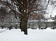
Lower Merion High School, pre-renovation building
Pupils living in the Lower Merion Township attend schools in the Lower Merion School District unless they go to a private school. The educational roots of the township stretch back to the Lower Merion Academy, one of the first public schools in the country.
There are six elementary schools, two middle schools, and two high schools (Lower Merion and Harriton High Schools). Students are split between schools depending on location of residence.
Notable graduates
Basketball star Kobe Bryant attended Lower Merion High School. He led the Aces to the state championship in 1996. Producer Marshall Herskovitz was also once a student at Lower Merion High School. Author Lisa Scottoline graduated from Lower Merion High School. Ronald Reagan's first secretary of state, Alexander Haig, graduated from Lower Merion High School, as did Robert Fagles. Lawrence Summers, the former president of Harvard University and the 71st Secretary of the Treasury, graduated from Harriton High School.
Actor David Boreanaz attended Rosemont School of the Holy Child in the Rosemont section of Lower Merion Township. His father, Dave Roberts, is a weatherman for WPVI-TV's Action News in Philadelphia, Pennsylvania.
Private schools
Rosemont School of the Holy Child, located in Rosemont and in Lower Merion Township, is affiliated with but not governed by the Roman Catholic Archdiocese of Philadelphia. The school is adjacent to Rosemont College.
Other private schools in the area include: the Shipley School, the Baldwin School, Waldron Mercy Academy, the Haverford School, the Agnes Irwin School, Friends Central School, French International School of Philadelphia, Kohelet Yeshiva High School and other schools outside the area.
Colleges and universities

Rosemont College's Main Building
Bryn Mawr College's Pembroke Hall
Bryn Mawr College, Harcum College, Rosemont College, and St. Charles Borromeo Seminary are located in Lower Merion Township. The campus of Saint Joseph's University straddles the city line between Lower Merion and Philadelphia while Haverford College straddles the lines between Lower Merion and Haverford Townships.
Miscellaneous education
The Japanese Language School of Philadelphia (JLSP, フィラデルフィア日本語補習授業校 Firaderufia Nihongo Hoshū Jugyō Kō), a supplementary Japanese school, holds its classes at the Friends Central School (FCS) in Wynnewood and in Lower Merion Township.[19][20] Residents are also serviced by the Lower Merion Library System.
Historic features
NRHP Historic Districts
- Bryn Mawr College Historic District
- Gladwyne Historic District
- Mill Creek Historic District
Notable buildings and structures
- 1690 House (1690), part of Mill Creek Historic District
Arboretum of the Barnes Foundation (1922)
Baldwin School (1890–91), NRHP listed
Black Rock Dam (1825)
Bryn Mawr Hospital (1893)
Bryn Mawr Theater (1926), NRHP listed
Dolobran (1881)
Flat Rock Tunnel (1838–40)- Green Hill Farms (1695), NRHP listed
Harriton House (1704), NRHP listed
Idlewild Farm Complex (1740), NRHP listed
Lankenau Medical Center (1953)
Lower Merion Academy (1812), NRHP listed
Manayunk Bridge (1918)
Merion Cricket Club (1897), NRHP listed
Merion Friends Meeting House (1714), NRHP listed- Merion Tribute House (1924)
Pencoyd (c.1690, demolished 1964)
Philadelphia Country Club (1890)
Rathalla, Rosemont College (1889–91), NRHP listed
St. Charles Borromeo Seminary (1871)
Suburban Square (1928)
M. Carey Thomas Library (1901–07), NRHP listed
General Wayne Inn (1704), NRHP listed
West Laurel Hill Cemetery (1869), NRHP listed
Whitehall Apartments (1925–26), NRHP listed
Woodmont (1891–94), NRHP listed- Yorklynne (1899-1902, demolished 1974), former campus of Episcopal Academy, removed from NRHP 1974
Notable people
Walter Annenberg, newspaper tycoon/philanthropist
Henry Arnold, WWII Air Force general- Albert C. Barnes
James Hadley Billington, Librarian of Congress
Kobe Bryant, basketball player, five-time NBA champion with the Los Angeles Lakers
- Taylor Buchholz
- John Debella
Betty Draper, fictional character in the television series Mad Men, raised in Lower Merion Township
Shelly Gross, film producer
Alexander Haig, Secretary of State
Patti LaBelle Grammy award winning singer- Jeffrey Lurie
- Garry Maddox
Brooke McCarter, actor, singer, director, producer star of the film 'The Lost Boys'- Tim McCarver
David Magerman, philanthropist
Teddy Pendergrass Grammy winning singer
M. Night Shyamalan, filmmaker
Martin J. Silverstein, attorney and diplomat who served as United States Ambassador [21]
Lawrence Summers, former Harvard president
See also
- Radnor Township
- Tredyffrin Township
- Easttown Township
- Haverford Township
- Whitemarsh Township
- Borough of Conshohocken
- Upper Merion Township
- Philadelphia
References
^ "2016 U.S. Gazetteer Files". United States Census Bureau. Retrieved Aug 14, 2017..mw-parser-output cite.citation{font-style:inherit}.mw-parser-output q{quotes:"""""""'""'"}.mw-parser-output code.cs1-code{color:inherit;background:inherit;border:inherit;padding:inherit}.mw-parser-output .cs1-lock-free a{background:url("//upload.wikimedia.org/wikipedia/commons/thumb/6/65/Lock-green.svg/9px-Lock-green.svg.png")no-repeat;background-position:right .1em center}.mw-parser-output .cs1-lock-limited a,.mw-parser-output .cs1-lock-registration a{background:url("//upload.wikimedia.org/wikipedia/commons/thumb/d/d6/Lock-gray-alt-2.svg/9px-Lock-gray-alt-2.svg.png")no-repeat;background-position:right .1em center}.mw-parser-output .cs1-lock-subscription a{background:url("//upload.wikimedia.org/wikipedia/commons/thumb/a/aa/Lock-red-alt-2.svg/9px-Lock-red-alt-2.svg.png")no-repeat;background-position:right .1em center}.mw-parser-output .cs1-subscription,.mw-parser-output .cs1-registration{color:#555}.mw-parser-output .cs1-subscription span,.mw-parser-output .cs1-registration span{border-bottom:1px dotted;cursor:help}.mw-parser-output .cs1-hidden-error{display:none;font-size:100%}.mw-parser-output .cs1-visible-error{font-size:100%}.mw-parser-output .cs1-subscription,.mw-parser-output .cs1-registration,.mw-parser-output .cs1-format{font-size:95%}.mw-parser-output .cs1-kern-left,.mw-parser-output .cs1-kern-wl-left{padding-left:0.2em}.mw-parser-output .cs1-kern-right,.mw-parser-output .cs1-kern-wl-right{padding-right:0.2em}
^ ab "Population and Housing Unit Estimates". Retrieved June 9, 2017.
^ https://www.census.gov/quickfacts/table/INC910214/4209144976,00
^ National Park Service (2010-07-09). "National Register Information System". National Register of Historic Places. National Park Service.
^ http://www.mainlinemedianews.com/articles/2012/11/14/main_line_times/news/doc50a39e1409e46905265837.txt?viewmode=fullstory
^ http://www.mainlinemedianews.com/articles/2011/04/19/main_line_times/news/doc4dad9899a7233877871104.txt?viewmode=fullstory
^ http://www.lowermerion.org/Index.aspx?page=53&recordid=4312
^ http://articles.philly.com/1999-12-21/news/25479431_1_bicycle-patrol-program-report-crimes-city-avenue
^ http://www.lowermerion.org/Index.aspx?page=202
^ Jones, Dick, ed. The First 300: the amazing and rich history of Lower Merion. Ardmore, PA: The Lower Merion Historical Society, 2000.
^ American FactFinder Archived 2012-10-19 at Archive.is. Factfinder.census.gov. Retrieved on 2013-07-21.
^ http://www.dvrpc.org/data/databull/rdb/db82/appedixa.xls
^ Census 2010: Pennsylvania. Usatoday.Com. Retrieved on 2013-07-21.
^ "American FactFinder". United States Census Bureau. Retrieved 2008-01-31.
^ American FactFinder. Factfinder.census.gov. Retrieved on 2013-07-21.
^ http://lowermerion.org/index.aspx?page=149
^ www.LowerMerion.org
^ http://emma.msrb.org/EP923809-EP717144-EP1118971.pdf
^ "Directions Archived 2015-04-02 at the Wayback Machine.." Japanese Language School of Philadelphia. Retrieved on March 30, 2014. "The Japanese Language School of Philadelphia utilizes the campus of: Friends Central School 1101 City Avenue, Wynnewood, PA"
^ "Community Profile Archived 2015-02-02 at the Wayback Machine.." Lower Merion Township. Retrieved on April 30, 2014. (contains maps of Lower Merion).
^ http://www.legis.state.pa.us/WU01/LI/RC/2015/S0027.pdf https://www.legis.state.pa.us/WU01/LI/NC/2015/20150127.pdf
External links
| Wikimedia Commons has media related to Lower Merion Township, Pennsylvania. |
- Lower Merion Township
- Lower Merion Historical Society
- Lower Merion School District
| Preceded by Haverford Township Delaware County | Bordering communities of Philadelphia | Succeeded by Whitemarsh Township |
Places adjacent to Lower Merion Township, Pennsylvania | ||||||||||
|---|---|---|---|---|---|---|---|---|---|---|
| ||||||||||
Municipalities and communities of Montgomery County, Pennsylvania, United States | ||
|---|---|---|
County seat: Norristown | ||
| Boroughs |
|  |
| Townships |
| |
| CDPs |
| |
| Unincorporated communities |
| |
| Footnotes | ‡This populated place also has portions in an adjacent county or counties | |
Delaware Valley | ||
|---|---|---|
| Counties |
|  |
| Major cities |
| |
| Cities and towns 50k-99k |
| |
| Cities and towns 30k-50k |
| |


