Monchy-le-Preux
| Monchy-le-Preux | ||
|---|---|---|
Commune | ||
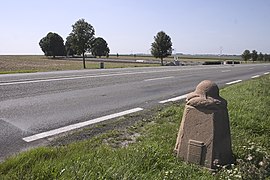 Stone marking the limit of the German advance in World War I | ||
| ||
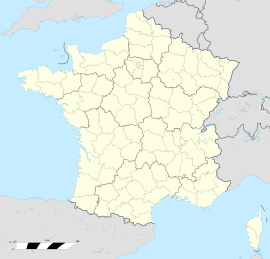  Monchy-le-Preux Location within Hauts-de-France region  Monchy-le-Preux | ||
Coordinates: 50°16′14″N 2°53′39″E / 50.2706°N 2.8942°E / 50.2706; 2.8942Coordinates: 50°16′14″N 2°53′39″E / 50.2706°N 2.8942°E / 50.2706; 2.8942 | ||
| Country | France | |
| Region | Hauts-de-France | |
| Department | Pas-de-Calais | |
| Arrondissement | Arras | |
| Canton | Arras-2 | |
| Intercommunality | Communauté urbaine d'Arras | |
| Government | ||
| • Mayor .mw-parser-output .nobold{font-weight:normal} (2008–2014) | Michel Zéchel | |
| Area1 | 9.26 km2 (3.58 sq mi) | |
| Population (2006)2 | 518 | |
| • Density | 56/km2 (140/sq mi) | |
| Time zone | UTC+1 (CET) | |
| • Summer (DST) | UTC+2 (CEST) | |
INSEE/Postal code | 62582 /62118 | |
| Elevation | 52–113 m (171–371 ft) (avg. 107 m or 351 ft) | |
1 French Land Register data, which excludes lakes, ponds, glaciers > 1 km2 (0.386 sq mi or 247 acres) and river estuaries. 2Population without double counting: residents of multiple communes (e.g., students and military personnel) only counted once. | ||

Monchy-le-Preux is a commune in the Pas-de-Calais department in the Hauts-de-France region of France.
Contents
1 Geography
2 History
3 Population
4 Places of interest
5 See also
6 References
7 External links
Geography
Monchy-le-Preux is situated 6 miles (10 km) southeast of Arras, at the junction of the D33 and the D339 roads. Junction 15 of the A1 autoroute is just a mile away.
History
Monchy was an important strategic position near to Arras during the 1914-18 war and bloody fighting ensued around the village. During the Battle of Arras it was from here that the Germans bombarded Arras and destroyed the belltower. Just outside Monchy, on the D939, a carved Vauthier Stone marks the boundary of the advancing German army during the First World War.
Population
| 1962 | 1968 | 1975 | 1982 | 1990 | 1999 | 2006 |
|---|---|---|---|---|---|---|
| 437 | 465 | 423 | 455 | 487 | 521 | 518 |
Census count starting from 1962: Population without duplicates | ||||||
Places of interest
- The Commonwealth War Graves Commission cemetery.
- The church of St.Martin, rebuilt along with much of the village, after World War I.
Monchy-le-Preux (Newfoundland) Memorial commemorating the sacrifice of the soldiers of the Newfoundland Regiment on 14 April 1917.- Two chapels.
- Remains of an old chateau.
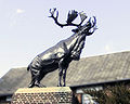
The caribou monument to the Newfoundland Regiment

The commemorative plaque

See also
- Communes of the Pas-de-Calais department
References
- INSEE commune file
External links
 | Wikimedia Commons has media related to Monchy-le-Preux. |
- The CWGC cemetery
Monchy-le-Preux on the Quid website (in French)
Authority control  |
|
|---|
 | This Arras arrondissement, Pas-de-Calais geographical article is a stub. You can help Wikipedia by expanding it. |


