Whitwick
| Whitwick | |
|---|---|
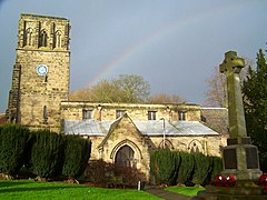 Whitwick Parish Church | |
 Whitwick Location within Leicestershire | |
| Civil parish |
|
| District |
|
| Shire county |
|
| Region |
|
| Country | England |
| Sovereign state | United Kingdom |
| Post town | Coalville |
| Postcode district | LE67 |
| EU Parliament | East Midlands |
Whitwick /ˈwɪtɪk/ is a large village in Leicestershire, England, close to the town of Coalville in the northwest of the county. It lies in an ancient parish which formerly included the equally historic villages of Thringstone and Swannington. It was an important manor in the Middle Ages, which once included Bardon and Markfield, parts of Hugglescote, Donington le Heath, Ratby, Bocheston, Newtown Unthank and Whittington.[1] As early as 1293, Whitwick had a weekly market and a four-day fair.[2] The population of Whitwick, according to the 2001 census was 10,815 persons. 8,092 of these fell into the 16-74 working age range, although only 4,689 were employed. The population of the village at the 2011 census had fallen to 8,612.[3]
Contents
1 History
1.1 Castle
1.2 Market and fair
1.3 Curious place names in Whitwick
1.4 Whitwick Colliery and mining disaster
2 Past industry and commerce
2.1 Framework knitting
2.2 Mineral water factories
2.3 Railway
3 Religion
3.1 St. John the Baptist Parish Church
3.2 Vicars of Whitwick 1551—1913
3.3 Daughter churches and national school
3.4 Other places of worship
3.4.1 Methodist and Baptist
3.4.2 Roman Catholic
4 Local public houses
5 Local government
6 Mount St Bernard and Gracedieu
7 The Friends of Holly Hayes Wood
8 Notable residents
9 References
10 External links
History
One of the earliest mentions of the place, as Witewic, is in the Domesday Book, the name of the settlement meaning either "The White Farm" or "Hwita's Farm", which may have been a reference to the outcrop of white sandstone found here.[4] It was listed amongst the lands given to Hugh de Grandmesnil[5] by King William I. There was said to be land for half a plough and woodland which was a furlong by half a furlong. Its value was two shillings.
Castle
Whitwick had a 12th-century motte and bailey castle, although no remains are left. This was held by the Earls of Leicester, though it was recorded as being ruinous by 1427. The foundations are said to have been visible at the end of the 18th century and a wall was still to be seen on the north side in 1893.[6] A licence to crenellate the structure was issued in 1320 to 'Henricus de Bello Monte, Consanguineus Regis' (Henry Beaumont, blood-relative of the king). The building work resulting from this licence may have provoked an attack by Sir John Talbot. Beaumont's claim to the land was from his wife's inheritance and, it seems, Talbot felt he had a claim to Whitwick. Twenty years later the capital message was worth nothing.[6]
The mound retains the title of Castle Hill and is surmounted by a 19th-century folly, with a castellated roofline. This was built in 1846 by a local landowner, Joseph Almond Cropper, as almshouses for the poor.
Market and fair
From 1838 until the early 20th century, there was a thriving weekly market held in Whitwick Market Place. As well as the regular local stallholders a number of Leicester tradesmen attended and it is remembered that old ladies used to bring their butter and other farm produce and line up alongside the gutter.[7] In the years following the First World War, competition from the larger and newer market at Coalville eventually resulted in its discontinuance.
The annual fair, or "wakes", was once a hugely popular event and coincided with the patronal festival of the parish church. At the height of its popularity in the early 20th century, it is remembered that the larger amusements stood in the opening in front of the White Horse public house and there were wild beast shows including seals swimming around in tanks. The local photographer would take snapshots (on glass) and deliver them while the customers waited. There was also once a 'Cabbage Street Wakes', of rather obscure origin, when cabbages were used to decorate the lampposts in Cademan Street.[7]
Curious place names in Whitwick
A popular affirmation is that the village of Whitwick contains three 'cities'. The City of Three Waters and the City of Dan are official postal addresses, situated respectively at the foot of Dumps Hill and Leicester Road. Over the years, there have been many contenders for the location of the 'third city', the most popular being The City of Hockley - an area located midway between the Cities of Three Waters and Dan, close to the parish church, and alongside the watercourse passing through the village. However, older residents have always maintained that this area was known simply as The Hockley, the prefix 'city', they suggest, being a retrospective appendage. Even the place-name 'Hockley' would appear to be a mystery. (The nearby South Derbyshire village of Woodville has an old lane signposted as, simply, 'The City').
Equally obscure is the origin of the name 'Dumps Hill', a steep incline forming part of a staggered cross-roads at the northern end of the village. Many theories have been expounded to account for its origin, one being that the houses built on the righthand side after the old railway bridge were constructed on the site of the old 'Dumblies' pig farm. Sheila Smith, in her 1984 history of Whitwick suggests that the name may be linked to framework knitting as in 1845 one Joseph Sheffield, giving evidence before the Commission into the plight of the framework knitters, makes reference to a type of stocking called 'dumps'. There are several surviving examples of framework knitters' cottages in the village, which can be recognised by elongated first storey windows, designed to allow greater inlet of light. A good example of such a cottage can be found at the foot of the Dumps.[8]
On Loughborough Road, there stands an old public house built of forest stone and known as 'The Man Within Compass'. This title is thought to be unique in England though again with uncertain origins. The pub is more commonly known as 'The Rag and Mop'; several of Whitwick's public houses developed nicknames, some of which - like The Rag and Mop - have origins which can only be guessed at. Other examples are 'Mary's House' (The Hare and Hounds) and 'Thripnies' (The Crown and Cushion, Silver Street - now closed).
Whitwick Colliery and mining disaster
Whitwick Colliery was opened on the outskirts of the parish by the engineer William Stenson near Long Lane in 1824, precipitating a massive expansion and development of this industry across the north west of Leicestershire. Though coal mining on this scale was only a major concern in Whitwick for a century and a half - a relatively short period for a settlement with a documented history spanning ten centuries - the place is still considered by many to be a colliery village due to the massive physical impact of the industry on the character of the village in terms of homogeneous red brick housing development during the 19th and 20th centuries. With the exception of the parish church, few - if any - ancient buildings survive.
There was a mining disaster on 19 April 1898 in Whitwick Number Five Pit which resulted in the deaths of thirty five men. Patrick O'Mara, one of those killed, was found on his knees with his rosary beads still in his hands. The youngest victim was John Albert Gee of Thringstone, who was aged just thirteen years. A memorial tablet to those killed can be found in the parish church at Coalville.
The pit was closed in the 1980s and the site is now occupied by a Morrisons store. An old winding wheel can still be seen at the foot of Leicester Road, erected as a monument to Whitwick's mining past following the closure of the colliery.
Past industry and commerce
Framework knitting
During the 18th century, framework knitting became an important cottage industry in the village, taking over from agriculture. As early as 1723/24, William Clark, son of William, was apprenticed to Joseph Howe. This apprenticeship was to run from Michaelmas 1723/24 for seven years.[8] By the beginning of the 19th century, Leicestershire, Nottinghamshire and Derbyshire had become the centre of the British hosiery trade, taking over from London. In 1832, it is recorded that there were some 33,000 knitting frames in use in the Midlands, of which the majority - 11,200, were in Leicestershire.[8]
In 1844, there were 423 knitting frames in Whitwick and by this time, the cottage industry had been in decline for some years. This appears to have been as a result of a change in fashions and also to the new type of hose being produced, which required fewer skills in the manufacture. From the middle of the 19th century, framework knitting began to be transferred from homes to the factories in larger towns. By 1851, it is recorded that the number of frames in Whitwick had dwindled to 240.[8]
Large hosiery factories appeared on Church Lane and at the top of The Dumps, shortly before the First World War.
Mineral water factories

Collection of late 19th- and early 20th-century Whitwick bottles
In addition to the usual village trades, Whitwick also once had three mineral water factories.
The largest of these was the firm of Bernard Beckworth on Cademan Street, which was established in 1875 and ran until the 1970s; it is listed in Kelly’s Directories of Leicestershire from 1904 through to 1941 as ‘Beckworth and Co. Ltd, Charnwood Mineral Water Works’.
By 1904, the firm of Stinson Brothers, based on Loughborough Road, had appeared. By 1912, this firm is listed as simply Horace Stinson and it had disappeared from the Whitwick Directories by 1928.
The firm of Richard Massey appears from 1916, listed at 36, Castle Street, Whitwick. Massey’s has disappeared by 1941.
A Stinson Bros codd bottle appeared among lots listed for auction in Barnsley (BBR Auctions) on Saturday 8 January 2006. It was described as a 9 inch tall emerald green glass codd bottle, embossed, ‘STINSON BROS/WHITWICK.’ The guide price was £80 - £100, the relatively high estimate presumably reflecting the rarity of the glass, but the bottle was in fact sold for £515. The bottle was turned up by a plough in a field opposite A.W.Waldrum’s Coal Merchant's premises on Grace Dieu Road, Whitwick and is the only known example.
There is also known to have existed a ‘Botanical Brewery’, though it is believed that this may have been a part of the Stinson or Massey enterprises, both of which later moved to Hermitage Road. Both firms are listed on Hermitage Road (under Coalville) in a trade directory of 1941. There are also known to have been examples of 19th-century bottles bearing the name of McCarthy and Beckworth, Coalville.
Railway

Whitwick station at road level.
Whitwick railway station was on the Charnwood Forest Railway which was constructed by the Charnwood Forest Company between 1881 and 1883.[9] This branch line ran from Coalville East (joined to the Ashby & Nuneaton Joint Railway (ANJR)) to the town of Loughborough, at the Derby Road Station. Passenger services ceased to operate on 13 April 1931, with freight services ceasing to operate on 12 December 1963. Whitwick railway station still has some surviving structures, the platform and the old station building, now the home of the Whitwick Historical Group, while the railway trackbed towards Coalville has been turned into a footpath.
Religion
St. John the Baptist Parish Church
The parish church of St. John the Baptist is an ancient structure, nestling in a natural amphitheatre, close to the confluence of two streams. A spring, emanating from under the chancel, is also discharged into the watercourse, through a piped outlet protruding from a stone wall at the east end of the churchyard. This spring is said to have been used during the 19th century as means of powering the bellows of the church organ. It is possible that this site was regarded as sacred in pre-Christian times, thereby influencing the choice of location for the church. It was also conjectured by the local historian, George Green of Loughborough, that a fragment of pre-Norman cross shaft would appear to be incorporated into the chancel wall, supporting the idea that a church may well have existed on this site in Anglo-Saxon times. However, there is no mention of a priest or church connected with Whitwick in the Domesday Survey, and in the absence of conclusive structural evidence beyond the thirteenth century, it is perhaps more likely that the church was built as a later adjunct to the nearby castle. The church we see today is mainly of 14th-century construction, with only the south doorway seeming to go back to the 13th century.[10] The massive decorated western tower contains a peal of eight bells, four of which were cast in 1628, and in the north aisle can be found the mutilated alabaster effigy of a knight, which tradition has to be that of Sir John Talbot, who died in 1365.[11] Talbot is said to have been a giant, and this accounts for the exceptional length of the monument.
The church was a victim of aggressive restoration during the 19th century, when the chancel was rebuilt by James Piers St Aubyn, 1848-1849. A vaulted substructure or crypt is situated beneath the chancel, but is not thought to have ever been used as a charnel house. The building of this understructure would have been necessary to maintain a level between the chancel and the nave due to the steepness of sloping ground at the east end.
In the south exterior wall of the nave, close by the porch, there is a canopied recess, which according to tradition once contained a doorway leading to vaults beneath the south aisle.[12] It is likely that this recess would once have contained a founder's tomb.
From 1319 until its dissolution in 1536, Whitwick Church was an endowment of the Benedictine priory of Upholland, near Wigan, Lancashire.[13] Following royal sequestration, the patronage of the living passed to the King and Whitwick Church remains one of forty-two churches nationally which are in the patronage of Her Majesty the Queen (in right of her Duchy of Lancaster).
Today, the church forms part of a united benefice with Thringstone and Swannington. The registers date from 1601.
The churchyard was closed for burials many years ago. In more recent years, many of the 18th- and 19th-century slate headstones were uprooted and moved in a line around the periphery of the southern portion of the graveyard; a 20th-century concrete war memorial now occupies the centre. Other stones were taken up and used for paving around the church.
Whitwick Cemetery, off Church Lane, was consecrated on 24 June 1874 and consists of about four acres. It was divided into three sections: Church of England, Catholic and Nonconformist and placed under the control of a joint burial committee. It contains four Commonwealth war graves of service personnel, one from World War I and three from World War II.[14]
Vicars of Whitwick 1551—1913
| Vicar | From | Until | Notes |
|---|---|---|---|
| Peter Fynche, MA | --- | 1551 | Also Rector of Ravenstone, 1549 - 59. |
| George Halsted | 1551 | 1553 | |
| Robert Grace | 1553 | 1576 | |
| Henry Lynney | 1576 | 1578 | Vicar of St Martin's, Leicester 1578 - 1585. |
| Thomas Hunt | 1578 | 1595 | |
| --- Barlowe | --- | --- | Recorded as Vicar in 1601 |
| Michael Crosley[15] | 1612 | 1642 | |
| John Brentnall, BA | 1675 | 1691 | Vicar of Elvaston cum Thurlston and Ambaston, 1691 - 1695; Vicar of Lockington 1695 - 1703. |
| William Hunt, MA | 1691 | 1700 | Rector of Cold Overton, 1700 - 1727. |
| William Ramser, BA | 1700 | 1705 | |
| John Hagger, BA | 1705 | 1711 | Vicar of Cropwell Bishop, 1711 - 1735. |
| William Banks, BA | 1711 | 1715 | |
| Charles Clarke, BA | 1715 | 1736 | |
| Charles Franke, MA | 1736 | 1767 | |
| Francis Harris, BA | 1767 | 1819 | Longest serving Vicar of Whitwick - 51 years, 6 months |
| Francis Merewether, MA | 1819 | 1864 | Also Rector of Coleorton, 1815 - 1864. Founded churches at Coalville, Swannington and Thringstone |
| Samuel Smith, DD | 1864 | 1875 | Changed surname to Pyemont in 1869. |
| Augustus Francis Tollemache, MA | 1875 | 1894 | |
| James Wilson Alexander Mackenzie, MA | 1894 | 1913 |
Daughter churches and national school
In the 19th and 20th centuries, new churches were built within the vast, ancient ecclesiastical parish of Whitwick as a result of population growth, all of which later came to serve independent parishes in their own right. Possibly more by coincidence than design,[citation needed] these daughter churches are dedicated respectively to the patron saints of Great Britain: St George's, Swannington was built in 1825; St Andrew's, Thringstone was built in 1862 and St David's, Broom Leys was founded in 1933. Christ Church, Coalville, was also formed partially out of Whitwick Parish in 1836, though the church here stands on land which was originally in the ancient parish of Ibstock, within the chapelry of Hugglescote.[16]
The churches at Swannington, Coalville and Thringstone all owe their existence to the zealous missionary drive of the Reverend Francis Merewether MA (1784–1864), Vicar of Whitwick for more than fifty years, and also Rector of Coleorton. Merewether, a low church theologian who preached and wrote prolifically against Roman Catholicism, was also successful in getting national schools established in these outlying parts of the parish as well as in Whitwick itself. He left behind him a small empire of Anglican expansion, wrought in part by a desire to counteract the 'papist' revival that he perceived to be sweeping the district, at the instigation of Ambrose de Lisle of Grace Dieu Manor.[17] Whitwick National School, a stone building in the Early English style still stands in the market place, now a Grade Two listed building. An extension to the school was provided in 1903, with access on silver street. The school was replaced later in the 20th century by a new Church of England school located at the foot of Parsonwood Hill. The old school is now used as a day nursery.

Saint David's Church, Broom Leys - a daughter church of Whitwick
St David's, Broom Leys was for more than thirty years served by a small wooden church which had originally served as a chapel at the Mowsley Sanitorium near Market Harborough, Leicestershire and was brought over to its present site in sections and duly re-erected. This small structure still stands near the present day 'futuristic' church, work on which was commenced in 1964. The foundation stone (a piece of Welsh slate from St David's in West Wales and presented by the dean of that cathedral) was laid on 26 September 1964 in the presence of about five hundred people. Above the front entrance of the church is the figure of St David, cast in 'ciment fondu' and coated with a bronze resin. The bricks are a 'Blaby Grey' and the stonework was provided by the local Whitwick Quarry.[7]
Other places of worship
Methodist and Baptist
Until the early 19th century, the parish church remained the only place of worship in the village. Then, in the 1820s, the Baptists erected a small chapel on Pares Hill and a society of Wesleyan Methodists opened a chapel on North Street (extended 1879).
From its foundation in 1823 until 1855, Whitwick Baptist Church remained a branch of the Hugglescote Church. In 1855, both the Whitwick and Coalville Baptist churches separated from Hugglescote and both churches were held under the pastorate of the Revd John Cholerton. A new Baptist church was built at Whitwick in 1861 at a cost of £318.10.0 by William Beckworth, a local builder, alongside the original chapel. By 1890, the minister was the Revd J. J. Berry. It is recorded that for his payment, he accepted the seat rents and weekly collections.[7]
A Primitive Methodist chapel appeared at the foot of Leicester Road (the present day Vicarage Street) in 1864 and a Wesleyan Methodist chapel was built on North Street in 1822 and which was extended in 1879. Wesleyan Reform Methodists also opened a chapel on North Street toward the end of the 19th century, and also in New Swannington in 1906. The Reform Chapel on North Street was used as a warehouse by 'Gracedieu Windows' until its demolition early in the twenty-first century, when the site was used for building development. The Wesleyan and Primitive Methodists united nationally in 1932 and the two societies in Whitwick finally merged in 1965, after which time the Vicarage Street chapel was used by the amalgamated congregations, the North Street chapel eventually being sold to the Church of England for use as a parish hall in about 1966. In 1972, a new Methodist church was built at the foot of Hall Lane and sadly, the Vicarage Street chapel (perhaps the most impressive example of 19th-century non-conformist architecture in the village) was demolished circa 1980, having fallen into a state of disrepair. The site is now occupied by a car park. Due to extensive housing development during the 1960s, a Methodist church was also built at the other end of Hall Lane in 1966, close to the Broom Leys cross-roads. It is noticeable that in more recent years, structural alterations have been carried out to this building to replace the original flat roof with a pitched one.
Roman Catholic
Due to the residency at Grace Dieu Manor of a zealous and wealthy convert to Roman Catholicism, Ambrose de Lisle, Whitwick became an important centre of the Roman Catholic revival.[18]
It was due to De Lisle that a Cistercian monastery, Mount St. Bernard Abbey, was established within the parish in 1835, and a church (designed by Pugin) was built on Parsonwood Hill in 1837.[18] In 1875, a small convent of Rosminian nuns was established in the presbytery, which had been built adjacent to the original church in August 1848, and which transferred to Loughborough in the twentieth century.[18] The presbytery, still referred to as 'The Old Convent' is now a private residence and was designated a Grade II listed building in 1983.[19]

Holy Cross Roman Catholic Church, Whitwick
In establishing his mission, De Lisle recruited a charismatic priest, Aloysius Gentili, from Rome, who arrived at Gracedieu in June 1840 and by May of the following year, De Lisle claimed that some five hundred and twenty persons had become converted to the catholic faith as a result of Gentilli's outreach.[18]
The present Roman Catholic Church was built in 1904 from the designs of Thomas Ignatius McCarthy. This was built on the opposite side of Parsonwood Hill, at which time Pugin's church was demolished, though the cemetery of the old church remains. A school was also built to the rear of the new church to replace the original school at Turylog (Thurlough), which had been opened in 1843. A tower was added to the new church in about 1910, from funds bequeathed by Samuel Wilson Hallam, landlord of the Queen's Head, Thringstone.[18] The tower contains a chime of fifteen bells operated by a baton keyboard, located in the first storey chamber of the tower and which was installed by Taylors of Loughborough in 1960.[20]
Local public houses

The Three Horseshoes
In Whitwick there has been, at one time or another, thirty-nine licensed establishments, either an Inn, Public House, Hostelry or Social Club. Most have now closed and even been demolished. Below is an itemised list of the establishments:[21][22][22]
| Premises | Status | Location | Opened | Closed | Notes |
|---|---|---|---|---|---|
| The Abbey Inn | Demolished | Cademen Street | 1911 | Now the site of grass and a bench. | |
| The Beaumont Arms "Uncle Toms Cabin" Whitiwck Working Mens Club & Institute (1920) | Closed | Market Place | 1830 | 2009 | |
| The Black Horse | Trading | Church Lane | No | ||
| The Blacksmiths Arms | Demolished | Hall Lane, Barn End Corner | 1908 | Now grass and path. | |
| The Boot Inn | Converted | Silver Street | 1836 | 1913 | Converted to a take-away; The Whitty Fish then Whitwick Spice now Doner Master Kebab Takeaway. |
| The Bulls Head | Trading | Warren Hills Road, Abbots Oak | No | ||
| The Castle Inn "Patsy Griffin's" | Converted | Castle Street | 1970 | Converted to private residence | |
| The Cricketers Arms | Demolished | Leicester Road | 1908 | Now No.18 | |
| The Crown and Cushion "Thripneys'" | Converted | Silver Street | 2002 | Converted to private residence | |
| The Crown and Cushion | Demolished | South Street | 1836 | 1923 | demolished c. 1970, now private drives. One of the last landlords of the establishment was Aston Villa F.C. footballer, Michael Noon, who played for the team 1899-1906. |
| The Duke of Newcastle | Demolished | North Street | Now Pare's Close. | ||
| The Duke of York | Demolished | Leicester Road | 1929 | Now a retirement home next to the fish shop. | |
| The Forest Rock Hotel | Closed | Leicester Road | One of the oldest hostelries in the area and had its own cricket team Whitwick Forest Rock. | ||
| The Foresters Arms | Closed | Leicester Road | 2009 | ||
| The Hare and Hounds "Mary's House" | Trading | City of Three Waters | No | ||
| The Hastings Arms | Demolished | Market Place | 1961 | Now the site of a car sales lot. | |
| The Hermitage Inn | Converted | Hermitage Road | 1905 | Converted to private residence | |
| The Hermitage Hotel | Demolished | Hermitage Road | 1905 | 1967 | Demolished due to subsidence, now No.107. |
| The Jolly Colliers | Closed | Thornborough Road, Thornborough | |||
| The Kings Arms "Mother Goose's" | Closed | Silver Street | 2017 | ||
| The Lady Jane | Trading | Hall Lane | No | The newest built pub in the area. | |
| The Liberal Club North Street Working Mens Club | Closed | North Street | 1888 | 2009 | |
| The Man Within Compass "Rag and Mop" | Trading | Loughborough Road | No | ||
| The Marquis of Granby | Demolished | Cademan Street | Now the entrance of King Richards Hill. A popular name in the area at the time as a tribute to General John Manners, whom favoured some soldiers and rewarded them with funds to invest into inns upon their retirement. | ||
| The New Inn "Tommy Potter's" | Demolished | Brooks Lane | 1934 | Demolished in 1934 for road clearance at the junction. | |
| The Oak of Whitwick (1998) The Beavers Lodge "The Pink Palace" (1983 ) | Closed | Talbot Street | The replacement of the original Prince of Wales. | ||
| The Prince of Wales | Demolished | Talbot Street | The building was demolished and rebuilt further away from the roadside. | ||
| The Queens Head | Demolished | Thornborough Road | |||
| The Joiners Arms The Railway Hotel (1882) | Converted | South Street | 1965 | The Railway Hotel was built on top of the Joiners arms, literally. The original building forms the basement level for the structure, which was increased when the road level was raised for the construction of the Charnwood Forest Railway. Now a window sales shop. | |
| The Royal George | Demolished | North Street | 1913 | Now a grassy area. | |
| The Talbot Arms | Converted | Talbot Street | 1931 | Converted to private residence | |
| The Three Crowns Inn The Three Crowns Hotel (1881) | Trading | Market Place | No | The current building replaced the earlier Inn. | |
The Three Horseshoes "Polly Burtons" | Trading | Leicester Road | No | Grade II listed building, CAMRA listed. | |
| The Victoria Hotel "Vic Bikers Pub" | Trading | Whitwick Road | No | ||
| The Wagon and Horses | Demolished | Church Lane | 1985 | Demolished in 1985 for road clearance, this pub was actually adjoined to The Black Horse. | |
| The White Hart | Converted | Dumps Lane | Converted to private residence | ||
| The White Horse | Trading | Market Place | No | Originally a farm house. Footballer Frank Middleton, Landlord from 1916–1928, had played for Derby County F.C (1901–1906) and Leicester Fosse (1906–1909). | |
| Whitwick & Thringstone Conservative Club Whitiwck Constitutional Club (1925) | Trading | Silver Street | 1897 | No | Originally a private residence. |
Local government
In the 2007 North West Leicestershire District Council elections, the British National Party won both Hugglescote and Whitwick - the first seats to be won by the BNP in Leicestershire and Whitwick gained its first Conservative councillor.[citation needed] Councillors for Whitwick are currently Derek Howe (Labour); Tony Gillard (Conservative) and Ray Woodward(Labour).
Since May 2013 Whitwick has been represented at County Council level by Leon Spence (Labour).
Following a campaign by local people, the District Council carried out a community governance review and made an Order on 12 May 2010 to set up the new Parish Council. Whitwick Parish Council held its Inaugural Meeting on 18 May 2011.
Mount St Bernard and Gracedieu
Mount St. Bernard Abbey, a Cistercian monastery was established in 1835 in the parish of Whitwick on the Charnwood Forest.
The current monastery was designed by the famous architect Augustus Welby Northmore Pugin, best known for his work on the Houses of Parliament.
In 1840, a hoard of two thousand Roman coins was discovered during ploughing operations at the monastery.[23]
Gracedieu Vineyard is south facing and was established in 1995 in Charnwood Forest. Its 'Green Man' wine is based on the Madeleine Angevine grape.[citation needed]
The Friends of Holly Hayes Wood
The Friends of Holly Hayes Wood are a community group who own and manage Coalville Meadows, which is a Site of Special Scientific Interest, and Holly Hayes Wood.
Notable residents
Thomas Elsdon Ashford - Recipient of the Victoria Cross.
References
^ Hadfield, CN: Charnwood Forest, 1952, p 47
^ Hoskins, W G: Leicestershire - A Shell Guide, 1970
^ "Civil Parish population 2011". Neighbourhood Statistics. Office for National Statistics. Retrieved 23 June 2016..mw-parser-output cite.citation{font-style:inherit}.mw-parser-output .citation q{quotes:"""""""'""'"}.mw-parser-output .citation .cs1-lock-free a{background:url("//upload.wikimedia.org/wikipedia/commons/thumb/6/65/Lock-green.svg/9px-Lock-green.svg.png")no-repeat;background-position:right .1em center}.mw-parser-output .citation .cs1-lock-limited a,.mw-parser-output .citation .cs1-lock-registration a{background:url("//upload.wikimedia.org/wikipedia/commons/thumb/d/d6/Lock-gray-alt-2.svg/9px-Lock-gray-alt-2.svg.png")no-repeat;background-position:right .1em center}.mw-parser-output .citation .cs1-lock-subscription a{background:url("//upload.wikimedia.org/wikipedia/commons/thumb/a/aa/Lock-red-alt-2.svg/9px-Lock-red-alt-2.svg.png")no-repeat;background-position:right .1em center}.mw-parser-output .cs1-subscription,.mw-parser-output .cs1-registration{color:#555}.mw-parser-output .cs1-subscription span,.mw-parser-output .cs1-registration span{border-bottom:1px dotted;cursor:help}.mw-parser-output .cs1-ws-icon a{background:url("//upload.wikimedia.org/wikipedia/commons/thumb/4/4c/Wikisource-logo.svg/12px-Wikisource-logo.svg.png")no-repeat;background-position:right .1em center}.mw-parser-output code.cs1-code{color:inherit;background:inherit;border:inherit;padding:inherit}.mw-parser-output .cs1-hidden-error{display:none;font-size:100%}.mw-parser-output .cs1-visible-error{font-size:100%}.mw-parser-output .cs1-maint{display:none;color:#33aa33;margin-left:0.3em}.mw-parser-output .cs1-subscription,.mw-parser-output .cs1-registration,.mw-parser-output .cs1-format{font-size:95%}.mw-parser-output .cs1-kern-left,.mw-parser-output .cs1-kern-wl-left{padding-left:0.2em}.mw-parser-output .cs1-kern-right,.mw-parser-output .cs1-kern-wl-right{padding-right:0.2em}
^ Watts, Victor et al., (2004) The Cambridge Dictionary of Place Names, Cambridge University Press, Cambridge.
ISBN 0-521-36209-1
^ Domesday Book: a Complete Transliteration. London: Penguin, 2003. p. 656
ISBN 0-14-143994-7
^ ab "Whitwick Castle, Coalville". The Gatehouse Website. 25 March 2015. Retrieved 1 April 2015.
^ abcd Introduction to Coalville, local publication, circa 1970
^ abcd Smith, Sheila, "A Brief History of Whitwick", published by Leicestershire Libraries and Information Service, Leicester, 1984.
^ Franks, D.L., (1975) The Ashby and Nuneaton Joint Railway together with The Charnwood Forest Railway Sheffield: Turntable Publications
^ Pevsner, Nikolaus: Leicestershire and Rutland (The Buildings of England)
^ Whitwick church website
^ College, JIW: Guide to Saint John the Baptist Parish Church, Whitwick, 1964
^ A History of the County of Lancaster, Volume 2, 1908, pp 111 - 112
^ [1] CWGC Cemetery Record, Coalville (Whitwick) Cemetery, breakdown from casualty record.
^ Alumni cantabrigienses; a biographical list of all known students, graduates and holders of office at the University of Cambridge (Volume pt 1 vol 1) online. (page 151 of 155)
^ Edgar Hawthorn, 'A Church, A People, A Story' (History of Christ Church, Coalville), 1952
^ Stephen Neale Badcock, Visitor's Guide To The Parish Church Of St. Andrew's, Thringstone, published 2005
^ abcde Robinson, Albert E: "Holy Cross Whitwick – A Brief History, 1837–1937", published by Whitwick Historical Group, 1987
^ http://www.britishlistedbuildings.co.uk/en-187884-house-opposite-entrance-to-roman-catholi
^ Index to carillons and chimes by Taylor; http://www.towerbells.org/data/IXfoundryTaylor.html
^ Public Houses in Whitwick, Stephen Neale Badcock, accessed 3 January 2009
^ ab http://www.whitwick.org.uk/history/alehouse.htm
^ C.N.Hadfield, Charnwood Forest, 1952
External links
| Wikimedia Commons has media related to Whitwick. |
- Whitwick Parish Church
- Whitwick Historical Group
- Whitwick Parish Council
Towns and villages of North West Leicestershire | ||
|---|---|---|
| Towns |
|  |
| Large villages |
| |
| Small villages |
| |
| Hamlets |
| |


