Westfjords
Vestfirðir | |
|---|---|
 The Vestfirðir area | |
| Country | Iceland |
| Seat | Ísafjörður |
| Area | |
| • Total | 22,271 km2 (8,599 sq mi) |
| Population (2007) | |
| • Total | 7,300 |
| • Density | 0.3/km2 (0.8/sq mi) |

A map of the Westfjords
The Westfjords or West Fjords (Icelandic: Vestfirðir, ISO 3166-2:IS: IS-4) is a large peninsula in northwestern Iceland and an administrative district. It lies on the Denmark Strait, facing the east coast of Greenland. It is connected to the rest of Iceland by a 7-km-wide isthmus between Gilsfjörður and Bitrufjörður. The Westfjords are very mountainous; the coastline is heavily indented by dozens of fjords surrounded by steep hills. These indentations make roads very circuitous and communications by land difficult. In addition many of the roads are closed by ice and snow for several months of the year. The Vestfjarðagöng road tunnel from 1996 has improved that situation. The cliffs at Látrabjarg comprise the longest bird cliff in the northern Atlantic Ocean and are at the westernmost point in Iceland. The Drangajökull glacier is located in the north of the peninsula and is the fifth-largest of the country, but the only glacier of the region.
Contents
1 Population
1.1 Main settlements in the Westfjords
2 Climate
3 Law
4 Image gallery
5 See also
6 References
7 External links
Population
The lack of flat lowlands in the area limits the potential for agriculture, which is mostly restricted to low-intensity sheep grazing near the fjords. Good natural harbors in many of the fjords and their proximity to fishing areas are vital for the local economy. The Westfjords are very sparsely populated: the total population in 2007 was 7,380. The district capital and by far the largest settlement is Ísafjörður (population around 4000).
| year | population | % of Iceland's population |
1920 | 13,443 | 14.24% |
1930 | 13,133 | 12.09% |
1940 | 13,130 | 10.80% |
1950 | 11,300 | 7.83% |
1960 | 10,507 | 5.86% |
1970 | 10,050 | 4.91% |
1980 | 10,479 | 4.53% |
1990 | 9,798 | 3.80% |
2000 | 8,150 | 2.86% |
2007 | 7,309 | 2.32% |
Main settlements in the Westfjords
- Reykhólar
- Bolungarvík
- Brjánslækur
- Ísafjörður
- Tálknafjörður
- Flateyri
- Suðureyri
- Hnífsdalur
- Súðavík
- Bíldudalur
- Þingeyri
- Patreksfjörður
- Skálanes
- Hólmavík
- Drangsnes
Climate
The box is for Goltur, at the tip of the peninsula 20 km (12 mi) northwest of Ísafjörður. Westfjords is generally the coldest area at sea level in Iceland, because of the East Greenland Current.
| Climate data for Goltur | |||||||||||||
|---|---|---|---|---|---|---|---|---|---|---|---|---|---|
| Month | Jan | Feb | Mar | Apr | May | Jun | Jul | Aug | Sep | Oct | Nov | Dec | Year |
| Record high °C (°F) | 10 (50) | 10 (50) | 11 (52) | 11 (52) | 17 (63) | 18 (64) | 19 (66) | 18 (64) | 15 (59) | 15 (59) | 13 (55) | 11 (52) | 19 (66) |
| Average high °C (°F) | 1 (33) | 2 (35) | 3 (37) | 4 (40) | 7 (44) | 9 (49) | 11 (51) | 11 (51) | 7 (45) | 5 (41) | 4 (40) | 2 (35) | 6 (42) |
| Daily mean °C (°F) | −2 (29) | 0 (32) | 1 (33) | 2 (36) | 4 (40) | 7 (45) | 8 (47) | 8 (47) | 6 (42) | 3 (38) | 3 (37) | 0 (32) | 3 (38) |
| Average low °C (°F) | −3 (26) | −2 (29) | −1 (30) | 1 (33) | 2 (36) | 5 (41) | 7 (44) | 7 (44) | 4 (40) | 2 (35) | 1 (34) | −1 (30) | 2 (35) |
| Record low °C (°F) | −11 (12) | −10 (14) | −13 (9) | −7 (19) | −4 (25) | −2 (28) | 2 (36) | 1 (34) | −3 (27) | −5 (23) | −9 (16) | −9 (16) | −13 (9) |
| Average relative humidity (%) | 75 | 77 | 76 | 79 | 77 | 82 | 83 | 81 | 82 | 79 | 80 | 78 | 79 |
| Mean daily sunshine hours | 6 | 9.2 | 12.7 | 16.6 | 20.7 | 23.4 | 21.5 | 18.1 | 13.9 | 10.3 | 6.9 | 4.6 | 13.7 |
| Source: Weatherbase[1] | |||||||||||||
Law
In 1615, 32 shipwrecked Basque whalers were killed by locals, after which the magistrate made it law that any Basque person seen in the region should be instantly killed. This law was repealed in May 2015.[2]
Image gallery
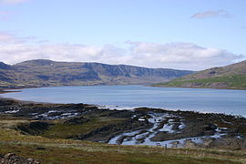
Westfjords

Dýrafjörður

Puffins in Látrabjarg

Oldest steel ship in Iceland

Látrabjarg

Hrafnseyrarheiði

Hvitanes

Suðureyri
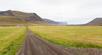
Landscape near Þingeyri


See also

- Barðaströnd
- Westfjords Heritage Museum
- Regions of Iceland
- Tunnels in Iceland
- Basque–Icelandic pidgin
References
^
"Weatherbase: WEATHER AVERAGES SUMMARY for Goltur, Iceland". Weatherbase. 2013..mw-parser-output cite.citation{font-style:inherit}.mw-parser-output .citation q{quotes:"""""""'""'"}.mw-parser-output .citation .cs1-lock-free a{background:url("//upload.wikimedia.org/wikipedia/commons/thumb/6/65/Lock-green.svg/9px-Lock-green.svg.png")no-repeat;background-position:right .1em center}.mw-parser-output .citation .cs1-lock-limited a,.mw-parser-output .citation .cs1-lock-registration a{background:url("//upload.wikimedia.org/wikipedia/commons/thumb/d/d6/Lock-gray-alt-2.svg/9px-Lock-gray-alt-2.svg.png")no-repeat;background-position:right .1em center}.mw-parser-output .citation .cs1-lock-subscription a{background:url("//upload.wikimedia.org/wikipedia/commons/thumb/a/aa/Lock-red-alt-2.svg/9px-Lock-red-alt-2.svg.png")no-repeat;background-position:right .1em center}.mw-parser-output .cs1-subscription,.mw-parser-output .cs1-registration{color:#555}.mw-parser-output .cs1-subscription span,.mw-parser-output .cs1-registration span{border-bottom:1px dotted;cursor:help}.mw-parser-output .cs1-ws-icon a{background:url("//upload.wikimedia.org/wikipedia/commons/thumb/4/4c/Wikisource-logo.svg/12px-Wikisource-logo.svg.png")no-repeat;background-position:right .1em center}.mw-parser-output code.cs1-code{color:inherit;background:inherit;border:inherit;padding:inherit}.mw-parser-output .cs1-hidden-error{display:none;font-size:100%}.mw-parser-output .cs1-visible-error{font-size:100%}.mw-parser-output .cs1-maint{display:none;color:#33aa33;margin-left:0.3em}.mw-parser-output .cs1-subscription,.mw-parser-output .cs1-registration,.mw-parser-output .cs1-format{font-size:95%}.mw-parser-output .cs1-kern-left,.mw-parser-output .cs1-kern-wl-left{padding-left:0.2em}.mw-parser-output .cs1-kern-right,.mw-parser-output .cs1-kern-wl-right{padding-right:0.2em}
Retrieved on June 1, 2013.
^ Tharoor, Ishaan (28 May 2015). "Iceland revokes 400-year-old legal right in Westfjords district to kill Basques on sight". The Independent. Retrieved 2 June 2015.
External links
 | Wikivoyage has a travel guide for Westfjords. |
- Westfjords Tourist Board
- Westfjords website
Images from the Westfjords (English and German)- Awarded "EDEN - European Destinations of Excellence" non traditional tourist destination 2010
- The Bestfjords blog
- Aurora Arktika
 | Wikimedia Commons has media related to Vestfirðir. |
Iceland articles | ||||||
|---|---|---|---|---|---|---|
| History |
|  | ||||
| Geography |
| |||||
| Politics |
| |||||
| Economy |
| |||||
| Society |
| |||||
| ||||||
Peninsulas of Iceland | ||
|---|---|---|
|  | |
Coordinates: 65°44′15″N 22°10′14″W / 65.73750°N 22.17056°W / 65.73750; -22.17056


