Post Falls, Idaho
Post Falls, Idaho | |
|---|---|
City | |
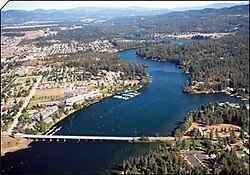 Downtown Post Falls along the Spokane River. | |
 Location of Post Falls in Kootenai County, Idaho. | |
 Post Falls, Idaho Location in the United States | |
| Coordinates: 47°42′43″N 116°56′53″W / 47.712°N 116.948°W / 47.712; -116.948 | |
| Country | United States |
| State | Idaho |
| County | Kootenai |
| Founded | 1871 |
| Incorporated | 1891 |
| Government | |
| • Type | City Council (6) & Mayor elected to four-year terms |
| • Mayor | Ron Jacobson |
| Area [1] | |
| • City | 14.53 sq mi (37.62 km2) |
| • Land | 14.49 sq mi (37.54 km2) |
| • Water | 0.03 sq mi (0.08 km2) |
| Elevation | 2,182 ft (665 m) |
| Population (2010)[2] | |
| • City | 27,574 |
| • Estimate (2016)[3] | 31,865 |
| • Density | 2,198.34/sq mi (848.80/km2) |
| • Metro | 144,265 (US: 283th) |
| • CSA | 679,989 (US: 71st) |
| Time zone | UTC−8 (Pacific (PST)) |
| • Summer (DST) | UTC−7 (PDT) |
| ZIP codes | 83854, 83877 |
| Area code(s) | 208 |
| FIPS code | 16-64810 |
GNIS feature ID | 0397061 |
| Website | www.postfallsidaho.org |
Post Falls is a city in Kootenai County, Idaho, between Coeur d'Alene and Spokane, Washington. It is a suburb of Coeur d'Alene, to the east, and a bedroom community to Spokane, to the west. The population was 27,574 at the 2010 census, up from 17,247 in 2000 census, making it Idaho's tenth largest city. The U.S. Census Bureau estimated 2014 population is 30,123.[4] Post Falls is also home to the last remaining 7-Eleven store in Idaho.[5]
Contents
1 History
2 Geography
3 Climate
4 Education
5 Demographics
5.1 2010 census
5.2 2000 census
6 Economy
6.1 Employers
7 Transportation
8 References
9 External links
History
Post Falls is named after Frederick Post, a German immigrant who constructed a lumber mill along the Spokane River in 1871 on land he purchased from Andrew Seltice, Chief of the Coeur d'Alene Tribe. The purchase of the land is preserved in a pictograph on a granite cliff in Treaty Rock park.
Geography
47°42′43″N 116°56′53″W / 47.712°N 116.948°W / 47.712; -116.948 [6]
According to the United States Census Bureau, the city has a total area of 14.11 square miles (36.54 km2), of which 14.07 square miles (36.44 km2) is land and 0.04 square miles (0.10 km2) is water.[7]
Post Falls is located four miles (6.4 km) east of the Washington-Idaho border along Interstate 90 in Kootenai County. It is bounded by Coeur d’Alene to the east, the state of Washington to the west, the Spokane River to the south and the Rathdrum prairie to the north. Post Falls is 20 miles (32 km) east of Spokane and approximately 100 miles (160 km) south of the Canada–United States border. The elevation of the city is 2,182 feet (665 m) above sea level.
Climate
Post Falls has a dry-summer continental climate (Dsa), with four very distinct seasons.
| Climate data for Post Falls, Idaho | |||||||||||||
|---|---|---|---|---|---|---|---|---|---|---|---|---|---|
| Month | Jan | Feb | Mar | Apr | May | Jun | Jul | Aug | Sep | Oct | Nov | Dec | Year |
| Record high °F (°C) | 60 (16) | 62 (17) | 73 (23) | 94 (34) | 98 (37) | 102 (39) | 108 (42) | 109 (43) | 102 (39) | 87 (31) | 71 (22) | 60 (16) | 109 (43) |
| Average high °F (°C) | 36 (2) | 40 (4) | 49 (9) | 56 (13) | 65 (18) | 72 (22) | 82 (28) | 82 (28) | 73 (23) | 58 (14) | 44 (7) | 34 (1) | 58 (14) |
| Average low °F (°C) | 26 (−3) | 27 (−3) | 31 (−1) | 37 (3) | 44 (7) | 51 (11) | 56 (13) | 56 (13) | 48 (9) | 38 (3) | 32 (0) | 25 (−4) | 39 (4) |
| Record low °F (°C) | −30 (−34) | −29 (−34) | −13 (−25) | 5 (−15) | 21 (−6) | 28 (−2) | 36 (2) | 32 (0) | 17 (−8) | 2 (−17) | −13 (−25) | −26 (−32) | −30 (−34) |
| Average precipitation inches (mm) | 3.18 (81) | 2.20 (56) | 2.32 (59) | 1.88 (48) | 2.16 (55) | 1.98 (50) | 0.94 (24) | 0.87 (22) | 1.01 (26) | 1.95 (50) | 3.72 (94) | 3.52 (89) | 25.73 (654) |
| Average snowfall inches (cm) | 17.1 (43) | 8.8 (22) | 5.6 (14) | 1.0 (2.5) | 0.4 (1.0) | 0.1 (0.25) | 0.0 (0.0) | 0.0 (0.0) | 0.0 (0.0) | 0.7 (1.8) | 7.0 (18) | 18.6 (47) | 59.3 (151) |
| Source: [8] | |||||||||||||
Education
The public schools are run by the Post Falls School District #273. Schools within Post Falls include:
- Classical Christian Academy
- Frederick Post Kindergarten
- Greensferry Elementary
- Mullan Trail Elementary
- Ponderosa Elementary
- Prairie View Elementary
- Seltice Elementary
- West Side Elementary
- West Ridge Elementary
- Post Falls Middle School
- Immaculate Conception Academy
- River City Middle School
- Post Falls High School
- New Visions Alternative High School
- Riverbend Professional Technical Academy
- Calvary Chapel Bible College Northwest
North Idaho College Workforce Training Center- St. Dominic School
Demographics
| Historical population | |||
|---|---|---|---|
| Census | Pop. | %± | |
| 1900 | 287 | — | |
| 1910 | 658 | 129.3% | |
| 1920 | 576 | −12.5% | |
| 1930 | 509 | −11.6% | |
| 1940 | 843 | 65.6% | |
| 1950 | 1,069 | 26.8% | |
| 1960 | 1,983 | 85.5% | |
| 1970 | 2,371 | 19.6% | |
| 1980 | 5,736 | 141.9% | |
| 1990 | 7,349 | 28.1% | |
| 2000 | 17,247 | 134.7% | |
| 2010 | 27,574 | 59.9% | |
| Est. 2016 | 31,865 | [3] | 15.6% |
| U.S. Decennial Census[9] | |||
As of 2009 the per capita income for the city was $32,696
2010 census
As of the census[2] of 2010, there were 27,574 people, 10,263 households, and 7,396 families residing in the city. The population density was 1,959.8 inhabitants per square mile (756.7/km2). There were 11,150 housing units at an average density of 792.5 per square mile (306.0/km2). The racial makeup of the city was 94.0% White, 0.4% African American, 0.9% Native American, 0.7% Asian, 0.1% Pacific Islander, 1.0% from other races, and 2.8% from two or more races. Hispanic or Latino of any race were 4.6% of the population.
There were 10,263 households of which 40.2% had children under the age of 18 living with them, 53.7% were married couples living together, 12.7% had a female householder with no husband present, 5.7% had a male householder with no wife present, and 27.9% were non-families. 21.9% of all households were made up of individuals and 7.9% had someone living alone who was 65 years of age or older. The average household size was 2.68 and the average family size was 3.10.
The median age in the city was 33 years. 29% of residents were under the age of 18; 8.7% were between the ages of 18 and 24; 28.6% were from 25 to 44; 22.4% were from 45 to 64; and 11.3% were 65 years of age or older. The gender makeup of the city was 48.8% male and 51.2% female.
2000 census
As of the census of 2000, there were 17,247 people, 6,369 households, and 4,668 families residing in the city. The population density was 1,786.1 people per square mile (689.3/km²). There were 6,697 housing units at an average density of 693.5 per square mile (267.7/km²). The racial makeup of the city was 96.13% White, 0.18% African American, 0.87% Native American, 0.56% Asian, 0.06% Pacific Islander, 0.60% from other races, and 1.61% from two or more races. Hispanic or Latino of any race were 2.55% of the population.
There were 6,369 households out of which 40.2% had children under the age of 18 living with them, 58.7% were married couples living together, 10.1% had a female householder with no husband present, and 26.7% were non-families. 20.5% of all households were made up of individuals and 8.2% had someone living alone who was 65 years of age or older. The average household size was 2.71 and the average family size was 3.13.
In the city, the population was spread out with 30.6% under the age of 18, 8.9% from 18 to 24, 31.8% from 25 to 44, 18.9% from 45 to 64, and 9.8% who were 65 years of age or older. The median age was 31 years. For every 100 females, there were 95.8 males. For every 100 females age 18 and over, there were 92.4 males.
The median income for a household in the city was $39,061, and the median income for a family was $42,758. Males had a median income of $32,284 versus $22,798 for females. The per capita income for the city was $18,692. About 7.1% of families and 9.4% of the population were below the poverty line, including 13.4% of those under age 18 and 7.5% of those age 65 or over.
Economy
[10] Due to the proximity of numerous lakes, rivers and mountains, Post Falls has developed tourism and retirement communities. There is an increasing number of retail, dining and entertainment businesses locating in the City.
Kootenai County traditionally has had a timber-based economy. That is changing gradually, as the manufacturing base has become more diverse. Jobs Plus, Inc., the local economic development organization has recruited several small to medium-sized firms to the county. Manufacturing jobs are found primarily in electronics, lumber and furniture at the present. Post Falls was the chosen location for Flexcel, Inc., a major furniture manufacturer that relocated to North Idaho nearly fifteen years ago and employs a workforce of 350. This was done with the help of Jobs Plus, Inc. and by creating an Urban Renewal District to help build infrastructure. This District closed out at the end of December 2001. Jobs Plus, Inc. has also just recently helped bring Center Partners, a call center business (employing a workforce of 300), and Buck Knives brought their manufacturing headquarters (workforce of 250) to the City. Also, Wal-Mart opened its new store in January 2002, employing a workforce of 300.
Construction of a private surgical hospital was completed in 2004. Sysco foods opened their distribution plant during 2005. This project was made possible by Jobs Plus, Urban Renewal, and the City working together. Also, a community development block grant for $500,000 was used to help fund a water tower (approximately $1,500,000 total cost) that was needed on the west side of town for development in that area. In 2007, Cabela’s opened its doors to a beautiful 130,000-square-foot (12,000 m2) retail store. Considerable economic development activity transpired in Post Falls in 2009 including the opening of ALK Source Materials/Biopol which is a Danish pharmaceutical company, a second Super Wal-Mart store that will be located near the new Cabelas store began its construction and is slated to open in early summer 2010, and Lowe’s Home Improvement finalized the purchase of land adjacent to the new Wal-Mart at the Pointe at Post Falls. Ground Force Manufacturing, a large construction equipment manufacturer, completed an addition that increased their production space by 20,000 square feet (1,900 m2) in 2009 in order to meet the heavy demands for their mining construction products around the globe. In 2010, additional commercial real estate activity is anticipated including the construction of the Lowe’s Home Improvement store mentioned earlier; a new 30,000 professional office building to house a high tech network-based solutions company named Ednetics; a 30,000 LEED certified industrial building to be the home of a subsidiary of Berg Integrated Systems will begin construction in early 2010; the State of Idaho Department of Labor will construct their new regional office here in Post Falls that will provide services to the northern five counties of Idaho; several restaurants are also anticipated to locate within the Pointe at Post Falls regional power center to take advantage of the retail traffic of Cabela’s and Wal-Mart; the City’s downtown area is expected to see a major mixed use project also take off with infrastructure and the first phase including a hospitality component begin construction; and finally the community anticipates that construction on the Beck Road Interchange with Interstate 90 will begin this fall ultimately providing service to the Pointe at Post Falls and EXPO on the north side of the freeway and the Riverbend Commerce Park and Greyhound Event Center on the south side of the Interstate 90.
Employers
Major employers in Post Falls in 2009 were:[11]
| Employer | Type of business | Employees |
|---|---|---|
| Ground Force | Manufacturing | 300 |
| Post Falls School District | Education | 690 |
Wal-Mart Stores | Retail / grocery | 450 |
| Kimball Furniture Group, Inc. | Manufacturer | closed |
| City of Post Falls | Government | 300 |
Buck Knives | Manufacturer | 220 |
Cabela's | Retail | 200 |
Sysco | Food services distributor | 185 |
| Accurate Molded Plastics | Manufacturer | 160 |
Transportation
 - Interstate 90 - Spokane (west), Coeur d'Alene (east)
The city is served by Interstate 90, the primary east-west highway of the northern United States, which crosses the Idaho panhandle through Post Falls. Two miles (3.2 km) east is its junction with State Highway 41, which extends 8 miles (13 km) north to Rathdrum. Post Falls is approximately 7 miles (11 km) west of U.S. Route 95, the state's primary north-south highway, which extends into Canada.
Air passenger service is available at Spokane International Airport, west of Spokane. Amtrak passenger rail service is available in Spokane and Sandpoint. Bus service and taxi service are available within the immediate area.
References
^ "2016 U.S. Gazetteer Files". United States Census Bureau. Retrieved Jul 26, 2017..mw-parser-output cite.citation{font-style:inherit}.mw-parser-output .citation q{quotes:"""""""'""'"}.mw-parser-output .citation .cs1-lock-free a{background:url("//upload.wikimedia.org/wikipedia/commons/thumb/6/65/Lock-green.svg/9px-Lock-green.svg.png")no-repeat;background-position:right .1em center}.mw-parser-output .citation .cs1-lock-limited a,.mw-parser-output .citation .cs1-lock-registration a{background:url("//upload.wikimedia.org/wikipedia/commons/thumb/d/d6/Lock-gray-alt-2.svg/9px-Lock-gray-alt-2.svg.png")no-repeat;background-position:right .1em center}.mw-parser-output .citation .cs1-lock-subscription a{background:url("//upload.wikimedia.org/wikipedia/commons/thumb/a/aa/Lock-red-alt-2.svg/9px-Lock-red-alt-2.svg.png")no-repeat;background-position:right .1em center}.mw-parser-output .cs1-subscription,.mw-parser-output .cs1-registration{color:#555}.mw-parser-output .cs1-subscription span,.mw-parser-output .cs1-registration span{border-bottom:1px dotted;cursor:help}.mw-parser-output .cs1-ws-icon a{background:url("//upload.wikimedia.org/wikipedia/commons/thumb/4/4c/Wikisource-logo.svg/12px-Wikisource-logo.svg.png")no-repeat;background-position:right .1em center}.mw-parser-output code.cs1-code{color:inherit;background:inherit;border:inherit;padding:inherit}.mw-parser-output .cs1-hidden-error{display:none;font-size:100%}.mw-parser-output .cs1-visible-error{font-size:100%}.mw-parser-output .cs1-maint{display:none;color:#33aa33;margin-left:0.3em}.mw-parser-output .cs1-subscription,.mw-parser-output .cs1-registration,.mw-parser-output .cs1-format{font-size:95%}.mw-parser-output .cs1-kern-left,.mw-parser-output .cs1-kern-wl-left{padding-left:0.2em}.mw-parser-output .cs1-kern-right,.mw-parser-output .cs1-kern-wl-right{padding-right:0.2em}
^ ab "American FactFinder". United States Census Bureau. Retrieved 2012-12-18.
^ ab "Population and Housing Unit Estimates". Retrieved June 9, 2017.
^ "Demographics". 2014-01-08. Archived from the original on 2014-01-11. Retrieved 2014-01-10.
^ "7-Eleven in Post Falls, Idaho on Google Maps".
^ "US Gazetteer files: 2010, 2000, and 1990". United States Census Bureau. 2011-02-12. Retrieved 2011-04-23.
^ "US Gazetteer files 2010". United States Census Bureau. Archived from the original on 2012-07-14. Retrieved 2012-12-18.
^ "Monthly Averages for Post Falls, ID". The Weather Channel. Archived from the original on 2016-01-14.
^ "Census of Population and Housing". Census.gov. Archived from the original on May 12, 2015. Retrieved June 4, 2015.
^ "Interactive Comprehensive Plan". Archived from the original (html) on 2012-05-10. Retrieved 2010-05-11.
^ "Principal Employers" (pdf). [Post Falls, Idaho]. Retrieved 2010-05-11.
[dead link]
External links
| Wikimedia Commons has media related to Post Falls, Idaho. |
- Official website
- Post Falls Chamber of Commerce
- Post Falls School District #273
Coordinates: 47°42′43″N 116°56′53″W / 47.712°N 116.948°W / 47.712; -116.948
Municipalities and communities of Kootenai County, Idaho, United States | ||
|---|---|---|
County seat: Coeur d'Alene | ||
| Cities |
| |
| CDPs |
| |
| Unincorporated communities |
| |
| Indian reservation |
| |
| Footnotes | ‡This populated place also has portions in an adjacent county or counties | |
Boise (capital) | ||
| Topics |
|  Seal of Idaho |
| Society |
| |
| Regions |
| |
| Larger cities |
| |
| Smaller cities |
| |
| Counties |
| |


