Natuna Besar
| Native name: (Pulau Natuna Besar) | |
|---|---|
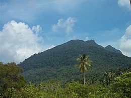 Mount Ranai on Natuna Besar | |
 Natuna Besar Show map of South China Sea 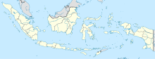 Natuna Besar Show map of Indonesia | |
| Geography | |
| Location | South China Sea |
| Coordinates | 3°59′45″N 108°11′17″E / 3.99583°N 108.18806°E / 3.99583; 108.18806 |
| Archipelago | Natuna Islands |
| Area | 1,720 km2 (660 sq mi) |
| Length | 58 km (36 mi) |
| Administration | |
| Province | Riau Islands |
| Regency | Natuna Islands |
| Largest town | Ranai |
| Demographics | |
| Ethnic groups | Malays |
Great Natuna Island (Pulau Natuna Besar in Indonesian) or just Natuna is the main island of the Middle Natuna Archipelago, which is part of the Riau Islands Province, Indonesia. It is also called Great Bunguran Island (Pulau Bunguran Besar).
The area of Great Natuna is 1,720 km². The highest point is Mount Ranai at 1,035 metres (3,396 ft). The island had a population of 52,000 inhabitants according to the 2010 census. The principal settlement is Ranai. The island can be reached by scheduled air services via Ranai Airport.
The island is home to three species of non-human primates: the slow loris (Nycticebus coucang), the long-tailed macaque (Macaca fascicularis), and the Natuna leaf monkey (a.k.a. Natuna pale-thighed surili, Presbytis natunae).[1][2]
A small number of wild goats live on the island as well as sea birds. Over 360 species of bird have been recorded on the island.[3]
There is a large mosque in the north-east corner of the island. The Masjid Agung Natuna was built over two years from 2007 to 2009.
On 18 December 2018, Indonesia opened a military base with over 1,000 personnel on Natuna Besar Island.[4]
Main islands of Riau Islands | ||
|---|---|---|
| Riau Archipelago |
| |
| Natuna Islands |
| |
| Anambas Islands |
| |
| Lingga Islands |
| |
References
^ Lammertink, Nijman, and Setiorini, 2003. Oryx 37(4):472-479
^ Brandon-Jones et al. 2004. Asian Primate Classification. International Journal of Primatology 25(1):97-164.
^ Lepage, Denis (2018). "Natuna Besar". Avibase - Bird Checklists of the World. Retrieved 10 September 2018..mw-parser-output cite.citation{font-style:inherit}.mw-parser-output .citation q{quotes:"""""""'""'"}.mw-parser-output .citation .cs1-lock-free a{background:url("//upload.wikimedia.org/wikipedia/commons/thumb/6/65/Lock-green.svg/9px-Lock-green.svg.png")no-repeat;background-position:right .1em center}.mw-parser-output .citation .cs1-lock-limited a,.mw-parser-output .citation .cs1-lock-registration a{background:url("//upload.wikimedia.org/wikipedia/commons/thumb/d/d6/Lock-gray-alt-2.svg/9px-Lock-gray-alt-2.svg.png")no-repeat;background-position:right .1em center}.mw-parser-output .citation .cs1-lock-subscription a{background:url("//upload.wikimedia.org/wikipedia/commons/thumb/a/aa/Lock-red-alt-2.svg/9px-Lock-red-alt-2.svg.png")no-repeat;background-position:right .1em center}.mw-parser-output .cs1-subscription,.mw-parser-output .cs1-registration{color:#555}.mw-parser-output .cs1-subscription span,.mw-parser-output .cs1-registration span{border-bottom:1px dotted;cursor:help}.mw-parser-output .cs1-ws-icon a{background:url("//upload.wikimedia.org/wikipedia/commons/thumb/4/4c/Wikisource-logo.svg/12px-Wikisource-logo.svg.png")no-repeat;background-position:right .1em center}.mw-parser-output code.cs1-code{color:inherit;background:inherit;border:inherit;padding:inherit}.mw-parser-output .cs1-hidden-error{display:none;font-size:100%}.mw-parser-output .cs1-visible-error{font-size:100%}.mw-parser-output .cs1-maint{display:none;color:#33aa33;margin-left:0.3em}.mw-parser-output .cs1-subscription,.mw-parser-output .cs1-registration,.mw-parser-output .cs1-format{font-size:95%}.mw-parser-output .cs1-kern-left,.mw-parser-output .cs1-kern-wl-left{padding-left:0.2em}.mw-parser-output .cs1-kern-right,.mw-parser-output .cs1-kern-wl-right{padding-right:0.2em}
^ "Indonesia opens military base near disputed South China Sea". ABS CBN News. December 19, 2018.
Coordinates: 3°56′52.93″N 108°12′45.31″E / 3.9480361°N 108.2125861°E / 3.9480361; 108.2125861
This Riau Islands location article is a stub. You can help Wikipedia by expanding it. |


