Kopački Rit
| Kopački Rit | |
|---|---|
IUCN category V (protected landscape/seascape) | |
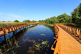
 Wooden trail through Kopački rit | |
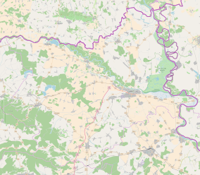
 Location of Kopački Rit in Osijek-Baranja County | |
| Location | Podunavlje |
| Nearest city | Osijek |
| Coordinates | 45°36′07″N 18°47′10″E / 45.602°N 18.786°E / 45.602; 18.786 |
| Area | 177 km2 (68 sq mi) |
| Established | 1976 |
| Administrator | State Institute for Nature Protection |
| Website | pp-kopacki-rit.hr |
Ramsar Wetland | |
| Official name | Nature Park Kopacki rit |
| Designated | 2 March 1993 |
| Reference no. | 583[1] |
Kopački Rit (Kopački Tršćak), is a nature park in eastern Croatia in the municipalities of Bilje and Kneževi Vinogradi. It is located northwest of the confluence of the Drava and the Danube, situated at the border with Serbia. It comprises many backwaters and ponds along the Danube. It is one of the most important, largest and most attractive preserved intact wetlands in Europe.
Contents
1 Fauna & Flora
2 Access
3 See also
4 References
5 External links
Fauna & Flora

Kopački rit water lilies and reeds
A part of Kopački Rit has been designated as a zoological reserve. Around 260 various bird species nest here (wild geese and ducks, great white egret, white stork, black stork, white-tailed eagle, crows, coots, gulls, terns, kingfishers, European green woodpecker, etc.), and there are many other species using this area as a temporary shelter on migration from the northern, cooler regions to the southern, warmer areas and vice versa.
There are 40-odd fish species (pike, ide, tench, bream, carp, catfish, pike-perch, perch, etc.). Several mammalian species inhabit the land (red deer, roe deer, wild boar, wildcat, pine marten, stone marten, weasel, sable, otter, etc.). Daily passes can be purchased at the visitors center.
Kopački Rit also has over 140 recorded species of plant—some of which are very rare and only found in a few places in Croatia. Notable species include white water lilies (lat. nyphaea alba), irises (lat. iris variegata); azola, black sedge (lat. carex nigra), reeds (lat. phragmites australis); siberian cattail; laxmannov cattail (lat. typha laxmannii); and vodoljub (lat. Butomus umbellatus).
Access

Kopački Rit Cafe and visitors center
The proximity of the big town of Osijek and its surroundings, as well as excellent communications (by road, railway, plane and ship) provide ready access to visitors. The beauty of "intact" nature, the multitude of waters, flora and fauna attract not only excursionists and visitors but also many experts and scientists from the whole of Europe.
Guided tourist visits by panoramic ships, boats, horse-drawn wagons or on foot are available. Some packages offer the possibility of photographing or video-recording animals, birds in particular.
Angling and hunting are allowed in certain parts of Kopački Rit that are put under less strict protection such as Vemeljski Dunavac, Danube river, Podunavlje channels, and the area by the Zlatna Greda pump station.
The international bicycle routes "Pannonian Peace Route" and "Danube Route" lead through Kopački Rit, which has become the first centre for cycle-tourists in Croatia. Bikes are also available for rent through the visitors center.
See also
- Ekološko društvo Zeleni Osijek
- Kopačevo
References
^ "Nature Park Kopacki rit". Ramsar Sites Information Service. Retrieved 25 April 2018..mw-parser-output cite.citation{font-style:inherit}.mw-parser-output .citation q{quotes:"""""""'""'"}.mw-parser-output .citation .cs1-lock-free a{background:url("//upload.wikimedia.org/wikipedia/commons/thumb/6/65/Lock-green.svg/9px-Lock-green.svg.png")no-repeat;background-position:right .1em center}.mw-parser-output .citation .cs1-lock-limited a,.mw-parser-output .citation .cs1-lock-registration a{background:url("//upload.wikimedia.org/wikipedia/commons/thumb/d/d6/Lock-gray-alt-2.svg/9px-Lock-gray-alt-2.svg.png")no-repeat;background-position:right .1em center}.mw-parser-output .citation .cs1-lock-subscription a{background:url("//upload.wikimedia.org/wikipedia/commons/thumb/a/aa/Lock-red-alt-2.svg/9px-Lock-red-alt-2.svg.png")no-repeat;background-position:right .1em center}.mw-parser-output .cs1-subscription,.mw-parser-output .cs1-registration{color:#555}.mw-parser-output .cs1-subscription span,.mw-parser-output .cs1-registration span{border-bottom:1px dotted;cursor:help}.mw-parser-output .cs1-ws-icon a{background:url("//upload.wikimedia.org/wikipedia/commons/thumb/4/4c/Wikisource-logo.svg/12px-Wikisource-logo.svg.png")no-repeat;background-position:right .1em center}.mw-parser-output code.cs1-code{color:inherit;background:inherit;border:inherit;padding:inherit}.mw-parser-output .cs1-hidden-error{display:none;font-size:100%}.mw-parser-output .cs1-visible-error{font-size:100%}.mw-parser-output .cs1-maint{display:none;color:#33aa33;margin-left:0.3em}.mw-parser-output .cs1-subscription,.mw-parser-output .cs1-registration,.mw-parser-output .cs1-format{font-size:95%}.mw-parser-output .cs1-kern-left,.mw-parser-output .cs1-kern-wl-left{padding-left:0.2em}.mw-parser-output .cs1-kern-right,.mw-parser-output .cs1-kern-wl-right{padding-right:0.2em}
External links
- Official website
Coordinates: 45°37′51″N 18°53′31″E / 45.63083°N 18.89194°E / 45.63083; 18.89194
