Siliguri
Siliguri | |
|---|---|
Metropolitan City | |
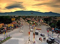  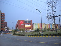  Top to bottom : Old view of Siliguri, Lions Clock Tower, City Centre Cosmos Mall | |
| Nickname(s): The Gateway of North East India | |
 Siliguri Location of Siliguri in West Bengal Show map of West Bengal  Siliguri Siliguri (India) Show map of India | |
| Coordinates: 26°43′N 88°26′E / 26.71°N 88.43°E / 26.71; 88.43Coordinates: 26°43′N 88°26′E / 26.71°N 88.43°E / 26.71; 88.43 | |
| Country | India |
| State | West Bengal |
| District | Darjeeling (62%), Jalpaiguri (38%) |
| Government | |
| • Type | Municipal Corporation |
| • Body | Siliguri Municipal Corporation |
| • Mayor | Ashok Bhattacharya(CPI(M)) |
| • ADM / SDO | P Harishanker (IAS) |
| Area [1] | |
| • Metropolitan City | 260 km2 (100 sq mi) |
| • Metro | 1,451 km2 (560 sq mi) |
| Area rank | 2nd in West Bengal |
| Highest elevation | 140 m (460 ft) |
| Lowest elevation | 114 m (374 ft) |
| Population (2011 census)[2] | |
| • Metropolitan City | 513,264 |
| • Density | 2,000/km2 (5,100/sq mi) |
| • Metro [3] | 705,579 |
| Languages | |
| • Official | Bengali and English[4] |
| Time zone | UTC+5:30 (IST) |
| PIN | 734 001-734 015 (city limits), 734 401-734 436(suburbs), 735 133-735 135 |
| Telephone code | 0353, 0354 |
| Vehicle registration | WB 73/74 |
Lok Sabha constituency | Darjeeling, Jalpaiguri |
Vidhan Sabha constituency | Siliguri, Dabgram-Phulbari, Matigara-Naxalbari, Phansidewa |
| Website | www.siligurismc.in, www.siliguri.gov.in |
1The coordinates given here are in metric system and based upon the Microsoft Encarta Reference Library Map Center 2005 2 The Vehicle Code given here based upon the Siliguri Sub Divisional Court, Darjeeling District Court and Jalpaiguri District Court documentations. | |
Siliguri (![]() pronunciation (help·info)) is a city which spans areas of the Darjeeling and Jalpaiguri districts in the Indian state of West Bengal. The city is located on the banks of the Mahananda River at the foothills of the Himalayas.
pronunciation (help·info)) is a city which spans areas of the Darjeeling and Jalpaiguri districts in the Indian state of West Bengal. The city is located on the banks of the Mahananda River at the foothills of the Himalayas.
Contents
1 Demographics
2 History
3 Transport
3.1 Rail
3.2 Air
4 Education
5 Climate
6 References
7 External links
Demographics
Based on Census data of 2011, the city has a population of 705,579, while the population of Siliguri UA/Metropolitan is 1,057,438.[2][3] Males constitute 51% of the population and females 49%. In Siliguri, 10% of the population is under six years of age.
Due to the city's booming economy, it has drawn people from Bihar, Jharkhand, North Bengal, North-East, Sikkim and other parts of India in search of livelihood. Siliguri also has a large population of Tibetans and a notable number of Bhutanese permanently settled in the city.[6]
History
Siliguri, the gateway of North East India,[7] gained municipal status in 1949 and grew into Municipal Corporation in 1994. I
Siliguri also known for its '4T': Tea, Timber, Tourism and Transport.[7]
Transport
Rail
A+ category railway station, New Jalpaiguri Junction railway station under Katihar railway division of Northeast Frontier Railway zone serves the city.
Two other stations, Siliguri Junction railway station and Siliguri Town railway station, also serve the city.[7]
Air
Bagdogra Airport is the airport serving Siliguri city. Flights connect to Kolkata, Guwahati, New Delhi, Mumbai, Bengaluru and Chennai.[7]
Education
Siliguri's schools are either government sponsored or run by private organisations.[citation needed]Bengali and English are the primary languages of instruction; Hindi and Nepali are also used.[citation needed] Schools in Siliguri follow the "10+2+3" plan.[citation needed] After completing their secondary education, students typically enroll in schools that have a higher secondary facility and are affiliated with the West Bengal Council of Higher Secondary Education, the ICSE, or the CBSE.[citation needed]
Government sponsored institutions in Siliguri: University of North Bengal (1962), a state university and North Bengal Medical College and Hospital (1968), a state medical college and other institutions are, Siliguri College, Siliguri College of Commerce, Surya Sen Mahavidyalaya, Acharya Prafulla Chandra Roy Government College, Kalipada Ghosh Tarai Mahavidyalaya, Siliguri Government Polytechnic, and Siliguri Boys' High School.
Private institutions include: Siliguri Institute of Technology and Nepali Kalyan High School.
Climate
| Climate data for Silguri | |||||||||||||
|---|---|---|---|---|---|---|---|---|---|---|---|---|---|
| Month | Jan | Feb | Mar | Apr | May | Jun | Jul | Aug | Sep | Oct | Nov | Dec | Year |
| Average high °C (°F) | 20 (68) | 22 (72) | 25 (77) | 30 (86) | 36 (97) | 38 (100) | 37 (99) | 36 (97) | 30 (86) | 28 (82) | 27 (81) | 21 (70) | 29 (85) |
| Average low °C (°F) | 8 (46) | 10 (50) | 14 (57) | 22 (72) | 24 (75) | 25 (77) | 26 (79) | 25 (77) | 23 (73) | 23 (73) | 16 (61) | 14 (57) | 19 (66) |
| Average precipitation mm (inches) | 8 (0.3) | 18 (0.7) | 33 (1.3) | 94 (3.7) | 300 (11.8) | 658 (25.9) | 818 (32.2) | 643 (25.3) | 538 (21.2) | 142 (5.6) | 13 (0.5) | 5 (0.2) | 3,266 (128.6) |
| [citation needed] | |||||||||||||
References
^ "West Bengal Govt. Department of Municipal Affairs"..mw-parser-output cite.citation{font-style:inherit}.mw-parser-output q{quotes:"""""""'""'"}.mw-parser-output code.cs1-code{color:inherit;background:inherit;border:inherit;padding:inherit}.mw-parser-output .cs1-lock-free a{background:url("//upload.wikimedia.org/wikipedia/commons/thumb/6/65/Lock-green.svg/9px-Lock-green.svg.png")no-repeat;background-position:right .1em center}.mw-parser-output .cs1-lock-limited a,.mw-parser-output .cs1-lock-registration a{background:url("//upload.wikimedia.org/wikipedia/commons/thumb/d/d6/Lock-gray-alt-2.svg/9px-Lock-gray-alt-2.svg.png")no-repeat;background-position:right .1em center}.mw-parser-output .cs1-lock-subscription a{background:url("//upload.wikimedia.org/wikipedia/commons/thumb/a/aa/Lock-red-alt-2.svg/9px-Lock-red-alt-2.svg.png")no-repeat;background-position:right .1em center}.mw-parser-output .cs1-subscription,.mw-parser-output .cs1-registration{color:#555}.mw-parser-output .cs1-subscription span,.mw-parser-output .cs1-registration span{border-bottom:1px dotted;cursor:help}.mw-parser-output .cs1-hidden-error{display:none;font-size:100%}.mw-parser-output .cs1-visible-error{font-size:100%}.mw-parser-output .cs1-subscription,.mw-parser-output .cs1-registration,.mw-parser-output .cs1-format{font-size:95%}.mw-parser-output .cs1-kern-left,.mw-parser-output .cs1-kern-wl-left{padding-left:0.2em}.mw-parser-output .cs1-kern-right,.mw-parser-output .cs1-kern-wl-right{padding-right:0.2em}
^ ab "Census Of India".
^ ab "Siliguri Metropolitan Urban Region Population 2011 Census". census2011.co.in. Retrieved 25 July 2016.
^ "Fact and Figures". www.wb.gov.in. Retrieved 7 December 2018.
^ http://www.census2011.co.in/census/city/192-siliguri.html
^ "Bangla immigrants to be pushed back". The Times Of India. 5 November 2001.
^ abcd http://www.siliguri.gov.in/about.html
External links
Siliguriat Wikipedia's sister projects
 Definitions from Wiktionary
 Media from Wikimedia Commons
 News from Wikinews
 Quotations from Wikiquote
 Texts from Wikisource
 Textbooks from Wikibooks
 Travel guide from Wikivoyage
 Resources from Wikiversity
- Siliguri Municipal Corporation
- Siliguri Jalpaiguri Development Authority
Cities, towns and locations in Darjeeling District | |||||||||
|---|---|---|---|---|---|---|---|---|---|
Cities, municipal and census towns |
| ||||||||
| Locations other than cities and towns |
| ||||||||
| See also |
| ||||||||
Cities, towns and locations in Jalpaiguri district | |||||||
|---|---|---|---|---|---|---|---|
Cities, municipal and census towns |
| ||||||
| Locations other than cities and towns |
| ||||||
| Related Topics |
| ||||||
Authority control |
|
|---|


