Capraia
Capraia Isola | ||
|---|---|---|
Comune | ||
| Comune di Capraia Isola | ||
 | ||
| ||
Location of Capraia Isola | ||
 Capraia Isola Location of Capraia Isola in Italy Show map of Italy  Capraia Isola Capraia Isola (Tuscany) Show map of Tuscany | ||
| Coordinates: 43°3′N 9°51′E / 43.050°N 9.850°E / 43.050; 9.850 | ||
| Country | Italy | |
| Region | Tuscany | |
| Province | Livorno (LI) | |
| Government | ||
| • Mayor | Gaetano Guarente | |
| Area | ||
| • Total | 19.0 km2 (7.3 sq mi) | |
| Elevation | 52 m (171 ft) | |
| Population (January 2017)[1] | ||
| • Total | 412 | |
| • Density | 22/km2 (56/sq mi) | |
| Demonym(s) | Capraiesi | |
| Time zone | UTC+1 (CET) | |
| • Summer (DST) | UTC+2 (CEST) | |
| Postal code | 57032 | |
| Dialing code | 0586 | |
| Website | Official website | |

Capraia is an Italian island, the northwesternmost of the seven islands of the Tuscan Archipelago, and the third largest after Elba and Giglio; it is also a comune (municipality) belonging to the Province of Livorno. The island has a population of about 400.
Contents
1 Geography
2 History
3 See also
4 References
4.1 Sources
5 External links
Geography
Capraia is 62 kilometres (39 mi) from the city of Livorno by sea, and 32 kilometres (20 mi) northwest of the island of Elba; it is slightly closer, at 30 kilometres (19 mi), to the island of Corsica. The island is accessible by ferries that depart from the port of Livorno.
Capraia is of volcanic origin, has an area of 19 square kilometres (7.3 sq mi) and its highest point is 466 metres (1,529 ft) above sea level. It is about 8 kilometres (5 mi) long (from Punta della Teglia to Punta dello Zenobio) and about 4 kilometres (2 mi) wide. It has a coastline that is about 30 kilometres (19 mi) in circumference. The island is part of the Arcipelago Toscano National Park and marine sanctuary.
The island's small harbour, Porto di Capraia, is connected to the village by the one and only asphalted road on the island. The village, dominated by the Fortress of St George, preserves its original characteristics unaltered. Sites of tourist interest include the Church of the Assunta, the Church of St Nicola and the Sacred Heart of Jesus, the Church and Convent of St Antonio, and the Church of St Stefano alla Piana. The Fortress is not open to visitors.
The island produces wine, and is a centre of the anchovy fishery. About 40 kilometres (25 mi) to the north is the island of Gorgona, which is also famous for its anchovies. In the summer the island is also a popular stopping point for yachts sailing between Livorno, Elba, and Corsica.
History

Fortress of St. George
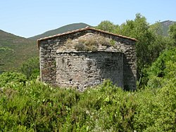
Santo Stefano
The Greeks called the island Aegyllon or Aegyllion (Αίγυλλον Greek for Goat Place, see also Giglio). Its current name may have originated in the Etruscan "carpa" - stone - a word that comes from the archaic Greek "Kalpe" - sepulchral stone. The Romans called the island Capraria, its name possibly then morphing to reflect the presence of wild goats (Greek: capros κάπρος, wild boar).
In the 4th century AD it housed a cenobium, where the church of St. Stephen now stands. The early 5th century poet Rutilius recorded that the island was "a mess" and that there were many monastic communities by his time.
In 1055 it was raided by Saracen pirates, and later the Republic of Pisa owned it. It became part of the Republic of Genoa after the Battle of Meloria, being assigned to the patrician Jacopo de Mari (1430). In 1540 the Genoese built the Forte San Giorgio on a pre-existing fortification that the Ottoman corsair Turgut Reis had demolished. The Genoese also built three coastal watch towers (part of a system of Genoese towers) to protect against pirates. The three are:
Torre del Porto (1541), which protected the entrance to the harbour, and which replaced or added to an earlier tower dating to 1510;
Torre dello Zenobito (1545); and
Torre delle Barbici (1699), also known as Torre della Teja or Torre della Regina. It is the only tower with a square shape, which makes it somewhat similar to the De Redin towers on Malta. Torre delle Barbici is in a fairly dilapidated state. Since 2009 a path connects it to the port.
In 1767 troops under Pasquale Paoli of the new independent Corsican Republic occupied Capraia. In 1796 the British, under Admiral Lord Horatio Nelson, occupied the island for a short time, following the creation of the short-lived Anglo-Corsican Kingdom. After the Congress of Vienna in 1815 annexed the Republic of Genoa to the Kingdom of Sardinia, Capraia became part of the province of Genoa. Then in 1925, it was assigned to Livorno.
Between 1873 and 1986 a penal colony occupied almost two-thirds of Capraia. In 1986 the government closed the penal colony and opened the island to visitors.
See also
- List of islands of Italy
- Tuscan Archipelago
- Punta Ferraione Lighthouse
References
^ Istat
Sources
![]() This article incorporates text from a publication now in the public domain: Chisholm, Hugh, ed. (1911). "Capraia". Encyclopædia Britannica (11th ed.). Cambridge University Press..mw-parser-output cite.citation{font-style:inherit}.mw-parser-output q{quotes:"""""""'""'"}.mw-parser-output code.cs1-code{color:inherit;background:inherit;border:inherit;padding:inherit}.mw-parser-output .cs1-lock-free a{background:url("//upload.wikimedia.org/wikipedia/commons/thumb/6/65/Lock-green.svg/9px-Lock-green.svg.png")no-repeat;background-position:right .1em center}.mw-parser-output .cs1-lock-limited a,.mw-parser-output .cs1-lock-registration a{background:url("//upload.wikimedia.org/wikipedia/commons/thumb/d/d6/Lock-gray-alt-2.svg/9px-Lock-gray-alt-2.svg.png")no-repeat;background-position:right .1em center}.mw-parser-output .cs1-lock-subscription a{background:url("//upload.wikimedia.org/wikipedia/commons/thumb/a/aa/Lock-red-alt-2.svg/9px-Lock-red-alt-2.svg.png")no-repeat;background-position:right .1em center}.mw-parser-output .cs1-subscription,.mw-parser-output .cs1-registration{color:#555}.mw-parser-output .cs1-subscription span,.mw-parser-output .cs1-registration span{border-bottom:1px dotted;cursor:help}.mw-parser-output .cs1-hidden-error{display:none;font-size:100%}.mw-parser-output .cs1-visible-error{font-size:100%}.mw-parser-output .cs1-subscription,.mw-parser-output .cs1-registration,.mw-parser-output .cs1-format{font-size:95%}.mw-parser-output .cs1-kern-left,.mw-parser-output .cs1-kern-wl-left{padding-left:0.2em}.mw-parser-output .cs1-kern-right,.mw-parser-output .cs1-kern-wl-right{padding-right:0.2em}
This article incorporates text from a publication now in the public domain: Chisholm, Hugh, ed. (1911). "Capraia". Encyclopædia Britannica (11th ed.). Cambridge University Press..mw-parser-output cite.citation{font-style:inherit}.mw-parser-output q{quotes:"""""""'""'"}.mw-parser-output code.cs1-code{color:inherit;background:inherit;border:inherit;padding:inherit}.mw-parser-output .cs1-lock-free a{background:url("//upload.wikimedia.org/wikipedia/commons/thumb/6/65/Lock-green.svg/9px-Lock-green.svg.png")no-repeat;background-position:right .1em center}.mw-parser-output .cs1-lock-limited a,.mw-parser-output .cs1-lock-registration a{background:url("//upload.wikimedia.org/wikipedia/commons/thumb/d/d6/Lock-gray-alt-2.svg/9px-Lock-gray-alt-2.svg.png")no-repeat;background-position:right .1em center}.mw-parser-output .cs1-lock-subscription a{background:url("//upload.wikimedia.org/wikipedia/commons/thumb/a/aa/Lock-red-alt-2.svg/9px-Lock-red-alt-2.svg.png")no-repeat;background-position:right .1em center}.mw-parser-output .cs1-subscription,.mw-parser-output .cs1-registration{color:#555}.mw-parser-output .cs1-subscription span,.mw-parser-output .cs1-registration span{border-bottom:1px dotted;cursor:help}.mw-parser-output .cs1-hidden-error{display:none;font-size:100%}.mw-parser-output .cs1-visible-error{font-size:100%}.mw-parser-output .cs1-subscription,.mw-parser-output .cs1-registration,.mw-parser-output .cs1-format{font-size:95%}.mw-parser-output .cs1-kern-left,.mw-parser-output .cs1-kern-wl-left{padding-left:0.2em}.mw-parser-output .cs1-kern-right,.mw-parser-output .cs1-kern-wl-right{padding-right:0.2em}
External links
| Wikimedia Commons has media related to Capraia Isola. |
- Capraia Isola — Tourist information
- Capraia Isola: News
Coordinates: 43°02′54″N 9°50′36″E / 43.04833°N 9.84333°E / 43.04833; 9.84333


