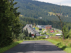
Loučná pod Klínovcem
Loučná pod Klínovcem | |
|---|---|
Town | |
 | |
 Loučná pod Klínovcem Location in the Czech Republic | |
| Coordinates: 50°24′46″N 12°59′23″E / 50.41278°N 12.98972°E / 50.41278; 12.98972Coordinates: 50°24′46″N 12°59′23″E / 50.41278°N 12.98972°E / 50.41278; 12.98972 | |
| Country | Czech Republic |
| Region | Ústí nad Labem |
| District | Chomutov |
| Municipality | Vejprty |
| Government | |
| • Mayor | Jana Müllerová |
| Area | |
| • Total | 20.89 km2 (8.07 sq mi) |
| Elevation | 865 m (2,838 ft) |
| Population (2006-10-02) | |
| • Total | 91 |
| • Density | 4.4/km2 (11/sq mi) |
| Time zone | UTC+1 (CET) |
| • Summer (DST) | UTC+2 (CEST) |
| Postal code | 431 91 |
| Website | www.obecni-urad.net/source/index.php?ID |
Loučná pod Klínovcem (German: Böhmisch Wiesenthal) is a town in the Czech Republic.
The town lies on the border with Germany. The German part of the divided town is called Oberwiesenthal.
External links
- Municipal website
| Wikimedia Commons has media related to Loučná pod Klínovcem. |
This Ústí nad Labem Region location article is a stub. You can help Wikipedia by expanding it. |


