La Grande, Oregon
La Grande, Oregon | |||
|---|---|---|---|
City | |||
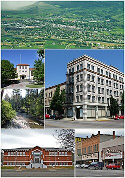 Clockwise: Aerial view of the city; the Foley Building; the Granada theater; Carnegie Library; Catherine Creek; Eastern Oregon University Pierce Library. | |||
| |||
| Motto(s): The Hub of Northeast Oregon | |||
 Location in Oregon | |||
| Coordinates: 45°19′38″N 118°5′36″W / 45.32722°N 118.09333°W / 45.32722; -118.09333Coordinates: 45°19′38″N 118°5′36″W / 45.32722°N 118.09333°W / 45.32722; -118.09333 | |||
| Country | United States | ||
| State | Oregon | ||
| County | Union | ||
| Incorporated | 1865 | ||
| Government | |||
| • Mayor | Steve Clements (D)[1] | ||
| Area [2] | |||
| • Total | 4.61 sq mi (11.94 km2) | ||
| • Land | 4.58 sq mi (11.86 km2) | ||
| • Water | 0.03 sq mi (0.08 km2) | ||
| Elevation | 2,785 ft (849 m) | ||
| Population (2010)[3] | |||
| • Total | 13,082 | ||
| • Estimate (2012[4]) | 13,048 | ||
| • Density | 2,856.3/sq mi (1,102.8/km2) | ||
| Time zone | UTC-8 (Pacific) | ||
| • Summer (DST) | UTC-7 (Pacific) | ||
| ZIP code | 97850 | ||
| Area code(s) | 458 and 541 | ||
| FIPS code | 41-40350[3] | ||
GNIS feature ID | 1164107[5] | ||
| Website | City Of La Grande Website | ||


La Grande /ləˈɡrænd/ is a city in Union County, Oregon, United States. Originally named "Brownsville," it was forced to change its name because that name was being used for a city in Linn County. Its name comes from an early French settler, Charles Dause, who often used the phrase "La Grande" to describe the area's beauty. The population was 13,082 at the 2010 census.[6] It is the county seat of Union County.[7] La Grande lies east of the Blue Mountains and southeast of Pendleton.
Contents
1 History
1.1 Early settlement
1.2 Growth
1.3 Sugar factory
2 Geography
2.1 Climate
3 Demographics
3.1 2010 census
3.2 2000 census
4 Museums and other points of interest
4.1 Commercial district
5 Education
6 Media
7 Transportation
7.1 Highways
7.2 Rail
7.3 Air
8 Notable people
9 References
10 External links
History
Early settlement
The Grande Ronde Valley had long been a waypoint along the Oregon Trail. The first permanent settler in the La Grande area was Benjamin Brown in 1861.[8] Not long after, the Leasey family and about twenty others settled there. The settlement was originally named after Ben Brown as Brown's Fort, Brown's Town, or Brownsville. There was already a Brownsville in Linn County, so when the post office was established in 1863, a more distinctive name was needed.[9][10] It was decided to use "La Grande", a phrase used by a Frenchman, Charles Dause, to describe the area's scenic splendor.[10] Before the post office was established, William Currey charged 50 cents a letter to carry the mail on horseback to and from the nearest post office, in Walla Walla, Washington.[10] La Grande was incorporated as a city in 1865,[9] and platted in 1868.[11]
Growth
La Grande grew rapidly during the late 1860s and early 1870s, partially because of the region's many gold mines and the valley's agricultural capabilities. The early business establishments centered on C Avenue between present day Fourth Street and the hillside on the west end.[10]
In 1884, the railroad came to the flat slightly east of "Old Town".[10] This helped the town to grow and gave rise to "New Town", centered on Adams Avenue and built parallel to the railroad tracks.
By 1900, La Grande's population was 2992, representing half of the population of Baker City.[12]
La Grande's Eastern Oregon University, formerly known as Eastern Oregon State College, began in 1929 as Eastern Oregon Normal School, a teachers college.[13]
Sugar factory
La Grande had a factory for processing sugar beets into raw sugar. The sugar beets came from the nearby Mormon town of Nibley, Oregon, and both were owned by the Oregon Sugar Company. R. Doerstling, the superintendent of the factory in 1899, reported seeing a Native American teepee built out of used cloth filters from the factory.[14]
Geography
According to the United States Census Bureau, the city has a total area of 4.61 square miles (11.94 km2), of which, 4.58 square miles (11.86 km2) is land and 0.03 square miles (0.08 km2) is water.[2] The town is a major hub in the Grande Ronde Valley. Mount Emily is a Grande Ronde Valley landmark towering over the city of La Grande to the north. It often features prominently on logos of local organizations,[citation needed] and is matched on the other side of the valley by a similar landmark, Mount Harris.
Climate
La Grande has a climate that could either be described as a humid continental climate (Köppen Dsb) or a rare cold oceanic or mediterranean climate (Köppen Cfb or Csb), with warm, dry summers and cold winters.
| Climate data for La Grande, OR | |||||||||||||
|---|---|---|---|---|---|---|---|---|---|---|---|---|---|
| Month | Jan | Feb | Mar | Apr | May | Jun | Jul | Aug | Sep | Oct | Nov | Dec | Year |
| Record high °F (°C) | 61 (16) | 66 (19) | 79 (26) | 88 (31) | 95 (35) | 100 (38) | 108 (42) | 104 (40) | 100 (38) | 89 (32) | 71 (22) | 59 (15) | 108 (42) |
| Average high °F (°C) | 38.1 (3.4) | 43.1 (6.2) | 51 (11) | 58.2 (14.6) | 67.1 (19.5) | 75.4 (24.1) | 85.9 (29.9) | 86 (30) | 76.5 (24.7) | 62.5 (16.9) | 46.6 (8.1) | 38.3 (3.5) | 60.7 (15.9) |
| Average low °F (°C) | 24.2 (−4.3) | 26.6 (−3) | 30.6 (−0.8) | 34.9 (1.6) | 41.8 (5.4) | 48.5 (9.2) | 53.5 (11.9) | 52 (11) | 43.9 (6.6) | 35.4 (1.9) | 30.2 (−1) | 24.5 (−4.2) | 37.2 (2.9) |
| Record low °F (°C) | −17 (−27) | −14 (−26) | 9 (−13) | 16 (−9) | 25 (−4) | 29 (−2) | 32 (0) | 32 (0) | 23 (−5) | 11 (−12) | −14 (−26) | −18 (−28) | −18 (−28) |
| Average precipitation inches (mm) | 1.86 (47) | 1.25 (32) | 1.48 (38) | 1.51 (38) | 1.88 (48) | 1.53 (39) | 0.65 (17) | 0.8 (20) | 0.76 (19) | 1.27 (32) | 1.95 (50) | 1.83 (46) | 16.77 (426) |
| Average snowfall inches (cm) | 7 (20) | 3 (10) | 1.4 (4) | 0.4 (1) | 0 (0) | 0 (0) | 0 (0) | 0 (0) | 0 (0) | 0.1 (0) | 2.1 (5) | 5.8 (15) | 19.9 (51) |
| Average precipitation days | 11 | 8 | 11 | 10 | 10 | 8 | 4 | 4 | 5 | 8 | 11 | 11 | 101 |
| Source: [15] | |||||||||||||
Demographics
| Historical population | |||
|---|---|---|---|
| Census | Pop. | %± | |
| 1870 | 240 | — | |
| 1880 | 400 | 66.7% | |
| 1890 | 2,583 | 545.8% | |
| 1900 | 2,991 | 15.8% | |
| 1910 | 4,843 | 61.9% | |
| 1920 | 6,913 | 42.7% | |
| 1930 | 8,050 | 16.4% | |
| 1940 | 7,747 | −3.8% | |
| 1950 | 8,635 | 11.5% | |
| 1960 | 9,014 | 4.4% | |
| 1970 | 9,645 | 7.0% | |
| 1980 | 11,354 | 17.7% | |
| 1990 | 11,766 | 3.6% | |
| 2000 | 12,327 | 4.8% | |
| 2010 | 13,082 | 6.1% | |
| Est. 2016 | 13,229 | [16] | 1.1% |
| source:[6][17][18][19] | |||
2010 census
As of the census of 2010, there were 13,082 people, 5,395 households, and 3,073 families residing in the city. The population density was 2,856.3 inhabitants per square mile (1,102.8/km2). There were 5,794 housing units at an average density of 1,265.1 per square mile (488.5/km2). The racial makeup of the city was 91.3% White, 0.8% African American, 1.4% Native American, 1.1% Asian, 1.5% Pacific Islander, 1.4% from other races, and 2.5% from two or more races. Hispanic or Latino of any race were 4.6% of the population.[3]
There were 5,395 households of which 28.4% had children under the age of 18 living with them, 40.7% were married couples living together, 11.7% had a female householder with no husband present, 4.6% had a male householder with no wife present, and 43.0% were non-families. 32.8% of all households were made up of individuals and 11.6% had someone living alone who was 65 years of age or older. The average household size was 2.30 and the average family size was 2.93.[3]
The median age in the city was 32.8 years. 22.4% of residents were under the age of 18; 16% were between the ages of 18 and 24; 23.6% were from 25 to 44; 23.3% were from 45 to 64; and 14.8% were 65 years of age or older. The gender makeup of the city was 48.1% male and 51.9% female.[3]
2000 census
As of the census of 2000, there were 12,327 people, 5,124 households, and 2,982 families residing in the city. The population density was 2,833.5 people per square mile (1,094.1/km²). There were 5,483 housing units at an average density of 1,260.3 per square mile (486.7/km²). The racial makeup of the city was 92.92% White, 1.26% Asian, 0.90% Pacific Islander, 0.78% Native American, 0.68% African American, 1.40% from other races, and 2.07% from two or more races. Hispanic or Latino of any race were 2.77% of the population.[3]
There were 5,124 households out of which 28.0% had children under the age of 18 living with them, 45.1% were married couples living together, 9.6% had a female householder with no husband present, and 41.8% were non-families. 32.2% of all households were made up of individuals and 12.6% had someone living alone who was 65 years of age or older. The average household size was 2.32 and the average family size was 2.93.[3]
In the city, the population was spread out with 23.6% under the age of 18, 16.5% from 18 to 24, 23.9% from 25 to 44, 21.4% from 45 to 64, and 14.6% who were 65 years of age or older. The median age was 34 years. For every 100 females, there were 90.3 males. For every 100 females age 18 and over, there were 88.0 males.[3]
The median income for a household in the city was $31,576, and the median income for a family was $40,508. Males had a median income of $32,746 versus $21,930 for females. The per capita income for the city was $16,550. About 8.3% of families and 15.2% of the population were below the poverty line, including 10.0% of those under age 18 and 9.0% of those age 65 or over.[3]
Museums and other points of interest
Commercial district
- See also Wikimedia Commons Photographs from the La Grande Commercial Historic District
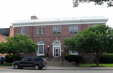
City Hall, located within the historic commercial district and formerly used as a Post Office and federal building.
La Grande includes a historic commercial district listed on the National Register of Historic Places in September 2001. The 42.7-acre (17.3 ha) district is bounded by the following:[20]
- on the northeast, by Oregon Railroad and Navigation Company/Union Pacific Railroad tracks along Jefferson Avenue;
- on the south, by Spring Avenue, Greenwood Street and Cove Avenue;
- on the southwest by Washington Avenue; and
- on the west by Fourth Street.
Education
The city is served by the La Grande School District, which includes Central Elementary School, Island City Elementary, Greenwood Elementary School, La Grande Middle School, and La Grande High School. La Grande is the home of Eastern Oregon University.
Media
The Observer is the local daily newspaper. Local radio stations include
KLBM AM 1450 and the following stations on the FM dial:
KEOL FM 91.7,
KUBQ FM 98.7,
KWRL FM 102.3,
KTVR FM 90.3
KCMB FM 104.7, and
KRJT FM 105.9.
La Grande is considered part of the Portland television market despite its distance from the western part of the state. Spanish language
Univision affiliate KUNP (channel 16) is licensed to La Grande as a sister station to Portland ABC affiliate KATU (channel 2), though is effectively considered to be a Portland station due to its former owner using a strategy of using fringe stations to serve an entire market through cable and satellite distribution with little to no local presence (KUNP's parent company maintains a translator station serving Portland proper).
Transportation
Highways

Eastbound exit 261 into La Grande off Interstate 84
 Interstate 84 is the main freeway through La Grande. It links La Grande with other nearby cities in the area (Pendleton, Baker City), as well as other regionally-important cities, including Boise, Idaho, Ontario and Umatilla, and Spokane and the Tri-Cities area of Washington.
 U.S. Route 30 serves as La Grande's main street under the name of Adams Avenue.
 Oregon Route 82 begins in La Grande at its intersection with Adams Avenue. The La Grande area's portion of OR 82 is Island Avenue, commonly known as the Island City Strip because it serves as the main road in La Grande's northern suburb of Island City. OR 82 ends in Wallowa County's town of Joseph, Oregon.
 Oregon Route 237 begins in nearby Island City and is the main route to the nearby town of Cove. It ends in North Powder and joins Interstate 84.
 Oregon Route 203 starts southeast of La Grande, near the intersection of Interstate 84 and U.S. Route 30. It is the main route to the town of Union. It ends a few miles north of Baker City. The Highway travels through Pyles Canyon and is an alternate route to Ladd Canyon, the main route out of the Grande Ronde Valley to the south.
Rail
La Grande is a crew change point on the Huntington and La Grande subdivisions of the Union Pacific Railroad, originally constructed through the area in 1884 by the Oregon Railway and Navigation Company.[21] Between 1977 and 1997, the city was a regular stop along the former route of Amtrak's Pioneer between Chicago, Salt Lake City, Portland and Seattle.[22] La Grande is also the junction of the Idaho Northern and Pacific Railroad's 20-mile (32 km) short line to Elgin.[23]
Air
- La Grande/Union County Airport
Notable people
Ray Baum, Oregon state legislator, lawyer
Bucky Buckwalter, former National Basketball Association coach and executive
William De Los Santos, poet, screenwriter and film director
Ron Gilbert, a computer game designer, best known for his work on several LucasArts adventure games
Steve House, professional climber and mountain guide
Darrell Ourso, Republican member of the Louisiana House of Representatives from Baton Rouge; formerly resided in La Grande[24]
Paul Wheaton permaculture theorist, software engineer
References
^ "Steve Clements". Democratic Party of Oregon. Retrieved 2 October 2015..mw-parser-output cite.citation{font-style:inherit}.mw-parser-output q{quotes:"""""""'""'"}.mw-parser-output code.cs1-code{color:inherit;background:inherit;border:inherit;padding:inherit}.mw-parser-output .cs1-lock-free a{background:url("//upload.wikimedia.org/wikipedia/commons/thumb/6/65/Lock-green.svg/9px-Lock-green.svg.png")no-repeat;background-position:right .1em center}.mw-parser-output .cs1-lock-limited a,.mw-parser-output .cs1-lock-registration a{background:url("//upload.wikimedia.org/wikipedia/commons/thumb/d/d6/Lock-gray-alt-2.svg/9px-Lock-gray-alt-2.svg.png")no-repeat;background-position:right .1em center}.mw-parser-output .cs1-lock-subscription a{background:url("//upload.wikimedia.org/wikipedia/commons/thumb/a/aa/Lock-red-alt-2.svg/9px-Lock-red-alt-2.svg.png")no-repeat;background-position:right .1em center}.mw-parser-output .cs1-subscription,.mw-parser-output .cs1-registration{color:#555}.mw-parser-output .cs1-subscription span,.mw-parser-output .cs1-registration span{border-bottom:1px dotted;cursor:help}.mw-parser-output .cs1-hidden-error{display:none;font-size:100%}.mw-parser-output .cs1-visible-error{font-size:100%}.mw-parser-output .cs1-subscription,.mw-parser-output .cs1-registration,.mw-parser-output .cs1-format{font-size:95%}.mw-parser-output .cs1-kern-left,.mw-parser-output .cs1-kern-wl-left{padding-left:0.2em}.mw-parser-output .cs1-kern-right,.mw-parser-output .cs1-kern-wl-right{padding-right:0.2em}
^ ab "US Gazetteer files 2010". United States Census Bureau. Archived from the original on 2012-01-24. Retrieved 2012-12-21.
^ abcdefghi "American FactFinder". United States Census Bureau. Retrieved 2012-12-21.
^ "Population Estimates". United States Census Bureau. Archived from the original on 2013-06-17. Retrieved 2013-06-02.
^ "US Board on Geographic Names". United States Geological Survey. 2007-10-25. Retrieved 2008-01-31.
^ ab "Profile of General Population and Housing Characteristics: 2010". 2010 Demographic Profile Data. U.S. Census Bureau. Archived from the original on 5 March 2014. Retrieved 8 October 2011.
^ "Find a County". National Association of Counties. Retrieved 2011-06-07.
^ Reavis, J (2005). "First Settlement in Grande Ronde Valley, Union County, Oregon". Oregon Genealogy. Retrieved October 22, 2011.
^ ab McArthur, Lewis A.; McArthur, Lewis L. (2003) [1928]. Oregon Geographic Names (7th ed.). Portland, Oregon: Oregon Historical Society Press. ISBN 978-0875952772.
^ abcde Reavis, J (2005). "La Grande History, Union County, Oregon". Oregon Genealogy. Retrieved December 29, 2008.
^ Bailey, Barbara Ruth (1982). Main Street: Northeastern Oregon. Oregon Historical Society. ISBN 0-87595-073-6.
^ Bailey, Barbara Ruth (1982). Main Street: Northeastern Oregon. Oregon Historical Society. p. 27. ISBN 0-87595-073-6.
^ Allen, Cain (2005). "Eastern Oregon Normal School". Oregon Historical Society. Retrieved December 3, 2009.
^ Arrington, Leonard J. (1966). Beet sugar in the West; a history of the Utah-Idaho Sugar Company, 1891-1966. University of Washington Press. p. 29. OCLC 234150.; see also Ogden Standard, 1899-07-08)
^ "LA GRANDE, OR (354622)". Western Regional Climate Center. Retrieved November 26, 2015.
^ "Population and Housing Unit Estimates". Retrieved June 9, 2017.
^ Moffatt, Riley. Population History of Western U.S. Cities & Towns, 1850-1990. Lanham: Scarecrow, 1996, 211.
^ "Subcounty population estimates: Oregon 2000-2007". United States Census Bureau, Population Division. 2009-03-18. Archived from the original (CSV) on 2009-05-15. Retrieved 2009-04-29.
^ "Incorporated Places and Minor Civil Divisions Datasets: Subcounty Population Estimates: April 1, 2010 to July 1, 2012". U.S. Census Bureau. Archived from the original on 17 June 2013. Retrieved 25 November 2013.
^ "Standards and Guidelines Manual for Historic Rehabilitation and Preservation for La Grande, Oregon" (PDF). City of La Grande. Retrieved 2011-08-22.
^ Halvorson, Gary (2005). "A 1940 Journey Across Oregon: Baker to La Grande". Oregon Secretary of State. Retrieved May 15, 2009.
^ "P.R.I.I.A Section 224 Pioneer Route Passenger Rail Study". Amtrak. Retrieved December 3, 2009.
^ "Idaho Northern & Pacific Railroad INPR #331". Union Pacific. Retrieved December 3, 2009.
^ "Darrell P. Ourso". intelius.com. Retrieved March 29, 2015.
External links
| Wikimedia Commons has media related to La Grande, Oregon. |
City of La Grande (official website)
La Grande listing in the Oregon Blue Book
"La Grande". The Oregon Encyclopedia.
- Union County Chamber of Commerce
Municipalities and communities of Union County, Oregon, United States | ||
|---|---|---|
County seat: La Grande | ||
| Cities |
|  |
| Unincorporated communities |
| |
| Indian reservation |
| |
| Ghost town |
| |
Salem (capital) | |||||||||
| Topics |
|  | |||||||
| Society |
| ||||||||
| Regions |
| ||||||||
| Metro areas |
| ||||||||
| Largest cities |
| ||||||||
| Counties |
| ||||||||


