Vrnjačka Banja
Vrnjačka Banja Врњачка Бања | |||
|---|---|---|---|
Town and municipality | |||
| Vrnjačka Banja | |||
 The Bridge of Love (Most ljubavi) | |||
| |||
 Location of the municipality of Vrnjačka Banja within Serbia | |||
| Coordinates: 43°37′25″N 20°53′37″E / 43.62361°N 20.89361°E / 43.62361; 20.89361Coordinates: 43°37′25″N 20°53′37″E / 43.62361°N 20.89361°E / 43.62361; 20.89361 | |||
| Country | |||
| Region | Šumadija and Western Serbia | ||
| District | Raška | ||
| Settlements | 14 | ||
| Government | |||
| • Mayor | Zoran Seizović (DS) | ||
| Area [1] | |||
| • Town | 19.06 km2 (7.36 sq mi) | ||
| • Municipality | 239 km2 (92 sq mi) | ||
| Elevation | 217 m (712 ft) | ||
| Population (2011 census)[2] | |||
| • Town | 10,065 | ||
| • Town density | 530/km2 (1,400/sq mi) | ||
| • Municipality | 27,527 | ||
| • Municipality density | 120/km2 (300/sq mi) | ||
| Time zone | UTC+1 (CET) | ||
| • Summer (DST) | UTC+2 (CEST) | ||
| Postal code | 36210 | ||
| Area code | +381(0)36 | ||
| Car plates | ВБ | ||
| Website | www.vrnjackabanja.gov.rs | ||


Vrnjačka Banja (Serbian Cyrillic: Врњачка Бања) is a town and municipality located in the Raška District of central Serbia. The population of the town is 10,065 inhabitants, while the population of the municipality is 27,527 inhabitants.
Vrnjačka Banja has many hot springs with temperatures measuring exactly that of the human body (37.5 degrees Celsius). It is home to a summer music festival Lovefest.
Contents
1 Settlements
2 Demographics
2.1 Ethnic groups
3 Economy
4 Tourism
4.1 Bridge of Love
5 Gallery
6 See also
7 References
8 External links
Settlements
Aside from the town of Vrnjačka Banja, the municipality includes the following settlements:
- Vraneši
- Vrnjci
- Vukušica
- Goč
- Gračac
- Lipova
- Novo Selo
- Otorci
- Podunavci
- Rsavci
- Ruđinci
- Stanišinci
- Štulac
Demographics
| Historical population | ||
|---|---|---|
| Year | Pop. | ±% p.a. |
| 1948 | 15,916 | — |
| 1953 | 17,394 | +1.79% |
| 1961 | 18,820 | +0.99% |
| 1971 | 21,940 | +1.55% |
| 1981 | 24,768 | +1.22% |
| 1991 | 25,875 | +0.44% |
| 2002 | 26,492 | +0.21% |
| 2011 | 27,527 | +0.43% |
| Source: [3] | ||
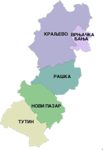
Vrnjačka Banja within Raška District
According to the last official census done in 2011, the municipality of Vrnjačka Banja has 27,527 inhabitants. Population density on the territory of the municipality is 115.2 inhabitants per square kilometer.
Ethnic groups
Most of its population is of Serbian ethnicity (96.2%) and 36.6% of the municipality’s population is urban. The ethnic composition of the municipality:[4]
| Ethnic group | Population |
|---|---|
| Serbs | 26,482 |
| Roma | 334 |
| Montenegrins | 107 |
| Macedonians | 33 |
| Yugoslavs | 30 |
| Others | 541 |
| Total | 27,527 |
Economy
The following table gives a preview of total number of employed people per their core activity (as of 2016):[5]
| Activity | Total |
|---|---|
| Agriculture, forestry and fishing | 160 |
| Mining | - |
| Processing industry | 1,332 |
| Distribution of power, gas and water | 55 |
| Distribution of water and water waste management | 215 |
| Construction | 358 |
| Wholesale and retail, repair | 1,050 |
| Traffic, storage and communication | 256 |
| Hotels and restaurants | 861 |
| Media and telecommunications | 41 |
| Finance and insurance | 63 |
| Property stock and charter | 15 |
| Professional, scientific, innovative and technical activities | 206 |
| Administrative and other services | 63 |
| Administration and social assurance | 428 |
| Education | 456 |
| Healthcare and social work | 802 |
| Art, leisure and recreation | 99 |
| Other services | 143 |
| Total | 6,605 |
Tourism
Situated in a great park full of trees with particularly charming houses, Vrnjačka Banja is the most celebrated and most popular spa town of Serbia and at same time, a very attractive recreation center. Surrounding Vrnjačka Banja are UNESCO protected medieval buildings, which serve as a reminder to early European civilization. Other nearby landmarks include the first court of the Serbian Archbishop, the Žiča Monastery and Sopoćani Monastery which both date back to the thirteenth century and the twelfth century Studenica Monastery all of which are nestled in the colorful Ibar River Valley.
It owes its reputation to its therapeutic effects known already to the Roman troops in the second century AD. It was upgraded by the Czech Baron Herder in 1835 after Prince Miloš Obrenović wanted it to be like Karlovy Vary, it has since received people from all of southern Europe, who came to rest or for treatment. Summers are pleasant, and the winter is mild. With organized walks along the tree bordered paths, Vrnjačka Banja is an ideal place to come to for one's own salvation. Natural springs can be found on five mineral water sources well positioned in the park. The warm water (36 degrees Celsius) is ideal for massage,[6] and cool (17 degrees Celsius) sufficiently reviving.
There are seven mineral springs +1 Legend in Vrnjačka Banja, from which first four are used for medical treatment:
- Topla voda (36.5°C)
- Snežnik (17°C)
- Slatina (24°C)
- Jezero (27°C)
- Beli izvor
- Borjak
- Vrnjačko vrelo
The hotels are numerous and have swimming pools and halls for games. In winter, it is convenient for skiing on the Goč, just a few kilometres away. In the summer, Vrnjačka Banja is transformed into one of greatest cultural centres in Serbia: literary soirées in a very nice library of the modern style, classical concerts under the column capitals and the festival of the cinema scenario. The restaurants are often on the border of a water current and offer terraces under the trees of the park.
The largest Opanak in the world, in the Guinness World Records since 2006, is the 3.2m shoe, size 450, weighing 222 kg (489 lb), made by opančar Slavko Strugarević, from Vrnjačka Banja, Serbia.[7]
Bridge of Love
One of the famous landmarks of Vrnjačka Banja is the Bridge of Love.
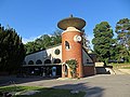
Gallery
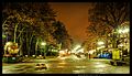
Town promenade

Town park building
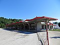
Bus station
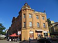
Building in town

Mercur Hotel

Villa Alexander

Hotel Promenada
Topla voda

Town hotel

Town central park

A stream and pine trees

Padlocks of the Bridge of Love'


See also
- List of spa towns in Serbia
- Trstenik Airport
References
^ "Municipalities of Serbia, 2006". Statistical Office of Serbia. Retrieved 2010-11-28..mw-parser-output cite.citation{font-style:inherit}.mw-parser-output q{quotes:"""""""'""'"}.mw-parser-output code.cs1-code{color:inherit;background:inherit;border:inherit;padding:inherit}.mw-parser-output .cs1-lock-free a{background:url("//upload.wikimedia.org/wikipedia/commons/thumb/6/65/Lock-green.svg/9px-Lock-green.svg.png")no-repeat;background-position:right .1em center}.mw-parser-output .cs1-lock-limited a,.mw-parser-output .cs1-lock-registration a{background:url("//upload.wikimedia.org/wikipedia/commons/thumb/d/d6/Lock-gray-alt-2.svg/9px-Lock-gray-alt-2.svg.png")no-repeat;background-position:right .1em center}.mw-parser-output .cs1-lock-subscription a{background:url("//upload.wikimedia.org/wikipedia/commons/thumb/a/aa/Lock-red-alt-2.svg/9px-Lock-red-alt-2.svg.png")no-repeat;background-position:right .1em center}.mw-parser-output .cs1-subscription,.mw-parser-output .cs1-registration{color:#555}.mw-parser-output .cs1-subscription span,.mw-parser-output .cs1-registration span{border-bottom:1px dotted;cursor:help}.mw-parser-output .cs1-hidden-error{display:none;font-size:100%}.mw-parser-output .cs1-visible-error{font-size:100%}.mw-parser-output .cs1-subscription,.mw-parser-output .cs1-registration,.mw-parser-output .cs1-format{font-size:95%}.mw-parser-output .cs1-kern-left,.mw-parser-output .cs1-kern-wl-left{padding-left:0.2em}.mw-parser-output .cs1-kern-right,.mw-parser-output .cs1-kern-wl-right{padding-right:0.2em}
^ "2011 Census of Population, Households and Dwellings in the Republic of Serbia: Comparative Overview of the Number of Population in 1948, 1953, 1961, 1971, 1981, 1991, 2002 and 2011, Data by settlements" (PDF). Statistical Office of Republic Of Serbia, Belgrade. 2014. ISBN 978-86-6161-109-4. Retrieved 2014-06-27.
^ "2011 Census of Population, Households and Dwellings in the Republic of Serbia" (PDF). stat.gov.rs. Statistical Office of the Republic of Serbia. Retrieved 11 January 2017.
^ "Попис становништва, домаћинстава и станова 2011. у Републици Србији" (PDF). stat.gov.rs. Republički zavod za statistiku. Retrieved 15 December 2016.
^ "ОПШТИНЕ И РЕГИОНИ У РЕПУБЛИЦИ СРБИЈИ, 2017" (PDF). stat.gov.rs (in Serbian). Statistical Office of the Republic of Serbia. Retrieved 20 February 2018.
^ "VRNJACKA BANJA". solarisresort.com. Retrieved 27 July 2014.
^ Smedia.rs, Napravio najveći opanak na svetu! (in Serbo-Croatian)
External links
| Wikimedia Commons has media related to Vrnjačka Banja. |
- Prezentacija Vrnjackog Karnevala - Carnival of Vrnjci
- Prezentacija opštine Vrnjačka Banja - Presentation of Municipality
- Turistički vodic Vrnjačke Banje(smeštaj,hoteli,apartmani,restorani) - Tourist guide Vrnjacka Banja (accommodation, hotels, apartments, restaurants)
- Prezentacija Specijalne bolnice Merkur - Special hospital Merkur
- Vodič kroz Vrnjačku Banju - Vrnjci Spa Tourist Guide
- Vrnjačka Banja Portal - Vrnjci Spa Portal
- Info at vrnjackabanjasrbija.rs
- Info at ivrnjackabanja.com
Info at smestajvrnjackabanja.com (in Serbian)
Info at banjavrnjacka.com (in Serbian)
Info at vrnjackabanjakarneval.com (in Serbian)
| Settlements |
|  |
|---|---|---|
| Landmarks |
| |
| Culture |
| |
| Notable people |
| |
Municipalities and cities of Serbia | ||||||||||||
|---|---|---|---|---|---|---|---|---|---|---|---|---|
| ||||||||||||
| ||||||||||||
| ||||||||||||
| ||||||||||||
| ||||||||||||


