Mongnai State
| Mongnai (Mone) | |||||
| State of the Shan States | |||||
| |||||
 | |||||
Capital | Mong Nai | ||||
History | |||||
| • | State founded | bf. 1800 | |||
| • | Abdication of the last Saopha | 1959 | |||
Area | |||||
| • | 1901 | 5,129 km2(1,980 sq mi) | |||
Population | |||||
| • | 1901 | 44,252 | |||
Density | 8.6 /km2 (22.3 /sq mi) | ||||

The Gate at Mongnai in a picture by Sir James George Scott.
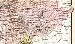
Mongnai, also known as Möngnai, Mone, Mōng Nai or Monē,[1] was a Shan state in what is today Burma. It belonged to the Eastern Division of the Southern Shan States.[1] Its capital was Mongnai town.[2]
Contents
1 History
1.1 Rulers (title Myoza)
1.2 Rulers (title Saopha)
2 References
3 External links
History
Möngnai state was founded before 1800. According to tradition a predecessor state named Saturambha had existed previously in the area.[3]
Mongnai included the substates of Kengtawng[1] and Kenghkam. The latter was annexed in 1882.[citation needed]
Rulers (title Myoza)
- c.1802 – 1848: Maung Shwe Paw
- 1848 – 1850: Maung Yit
- 1850 – 1851: U Po Ka
- 1852: U Shwe Kyu
Rulers (title Saopha)
Ritual style Kambawsa Rahta Mahawunthiri Pawara Thudamaraza.[4]
- 1852 – 1875: Hkun Nu Nom
- 1875 – 1882: Hkun Kyi (1st time) (1847–1914)
- 1882 – 1888: Twet Nga Lu (usurper) (d. 1888)
- 1888 – 1914: Hkun Kyi (2nd time) (s.a.)
- 1914 – 1928: Hkun Kyaw Sam
- 1928 – 1949: Hkun Kyaw Ho (d. 1949)
- 1949 – 1958: Sao Pye
References
^ abc Chisholm, Hugh, ed. (1911). . Encyclopædia Britannica. 18 (11th ed.). Cambridge University Press. p. 710..mw-parser-output cite.citation{font-style:inherit}.mw-parser-output .citation q{quotes:"""""""'""'"}.mw-parser-output .citation .cs1-lock-free a{background:url("//upload.wikimedia.org/wikipedia/commons/thumb/6/65/Lock-green.svg/9px-Lock-green.svg.png")no-repeat;background-position:right .1em center}.mw-parser-output .citation .cs1-lock-limited a,.mw-parser-output .citation .cs1-lock-registration a{background:url("//upload.wikimedia.org/wikipedia/commons/thumb/d/d6/Lock-gray-alt-2.svg/9px-Lock-gray-alt-2.svg.png")no-repeat;background-position:right .1em center}.mw-parser-output .citation .cs1-lock-subscription a{background:url("//upload.wikimedia.org/wikipedia/commons/thumb/a/aa/Lock-red-alt-2.svg/9px-Lock-red-alt-2.svg.png")no-repeat;background-position:right .1em center}.mw-parser-output .cs1-subscription,.mw-parser-output .cs1-registration{color:#555}.mw-parser-output .cs1-subscription span,.mw-parser-output .cs1-registration span{border-bottom:1px dotted;cursor:help}.mw-parser-output .cs1-ws-icon a{background:url("//upload.wikimedia.org/wikipedia/commons/thumb/4/4c/Wikisource-logo.svg/12px-Wikisource-logo.svg.png")no-repeat;background-position:right .1em center}.mw-parser-output code.cs1-code{color:inherit;background:inherit;border:inherit;padding:inherit}.mw-parser-output .cs1-hidden-error{display:none;font-size:100%}.mw-parser-output .cs1-visible-error{font-size:100%}.mw-parser-output .cs1-maint{display:none;color:#33aa33;margin-left:0.3em}.mw-parser-output .cs1-subscription,.mw-parser-output .cs1-registration,.mw-parser-output .cs1-format{font-size:95%}.mw-parser-output .cs1-kern-left,.mw-parser-output .cs1-kern-wl-left{padding-left:0.2em}.mw-parser-output .cs1-kern-right,.mw-parser-output .cs1-kern-wl-right{padding-right:0.2em}
^ Imperial Gazetteer of India, v. 17, p. 405.
^ Ben Cahoon (2000). "World Statesmen.org: Shan and Karenni States of Burma". Retrieved 21 December 2010.
^ "WHKMLA : History of the Shan States". 18 May 2010. Retrieved 21 December 2010.
External links
- "Gazetteer of Upper Burma and the Shan states"
- The Imperial Gazetteer of India
Coordinates: 20°31′N 97°52′E / 20.517°N 97.867°E / 20.517; 97.867
This Burmese history article is a stub. You can help Wikipedia by expanding it. |
This Shan State location article is a stub. You can help Wikipedia by expanding it. |


