Ugu District Municipality
Ugu | ||
|---|---|---|
District municipality | ||
| ||
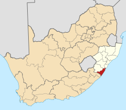 Location of Ugu District Municipality within KwaZulu-Natal | ||
| Coordinates: 30°45′S 30°26′E / 30.750°S 30.433°E / -30.750; 30.433Coordinates: 30°45′S 30°26′E / 30.750°S 30.433°E / -30.750; 30.433 | ||
| Country | South Africa | |
| Province | KwaZulu-Natal | |
| Seat | Port Shepstone | |
| Local municipalities | List
| |
| Government [1] | ||
| • Type | Municipal council | |
| • Mayor | Sithembiso Bhekizenzo Cele | |
| Area | ||
| • Total | 5,047 km2 (1,949 sq mi) | |
| Population (2011)[2] | ||
| • Total | 722,484 | |
| • Density | 140/km2 (370/sq mi) | |
| Racial makeup (2011) [2] | ||
| • Black African | 90.6% | |
| • Coloured | 0.8% | |
| • Indian/Asian | 3.4% | |
| • White | 4.9% | |
First languages (2011) [3] | ||
| • Zulu | 82.7% | |
| • English | 8.3% | |
| • Xhosa | 4.3% | |
| • Afrikaans | 2.1% | |
| • Other | 2.6% | |
| Time zone | UTC+2 (SAST) | |
| Municipal code | DC21 | |

Ugu is one of the 11 districts of KwaZulu-Natal province of South Africa. Ugu is Zulu for "coast". It governs the KZN South Coast and its seat is Port Shepstone. The majority of its 722,484 people speak IsiZulu (2011 Census). The district code is DC21.
Contents
1 Geography
1.1 Neighbours
1.2 Local municipalities
2 Demographics
2.1 Languages
2.2 Gender
2.3 Ethnic group
2.4 Age
3 Politics
3.1 Election results
4 References
5 External links
Geography
Neighbours
Ugu is surrounded by:
Umgungundlovu to the north (DC22)
eThekwini to the north-east (Durban)- the Indian Ocean to the east
OR Tambo in Eastern Cape to the south-west (DC15)
Harry Gwala to the west (DC43)
Local municipalities
The district contains the following local municipalities:
| Local municipality | Population | % | Dominant language |
|---|---|---|---|
| Ray Nkonyeni | 308 675 | 37.70% | Zulu |
| Umzumbe | 193 764 | 27.52% | Zulu |
| uMuziwabantu | 92 322 | 13.11% | Zulu |
| uMdoni | 62 290 | 8.85% | Zulu |
Demographics
The following statistics are from the 2011 census.
Languages
| Language | Population | % |
|---|---|---|
| IsiZulu | 588,483 | 82.69% |
| English | 58,801 | 8.26% |
| IsiXhosa | 30,440 | 4.28% |
| Afrikaans | 14,616 | 2.05% |
| IsiNdebele | 7,191 | 1.01% |
| Setswana | 3,441 | 0.48% |
| Sign language | 2,704 | 0.38% |
| Other | 2,198 | 0.31% |
| Sepedi | 1,558 | 0.22% |
| Sesotho | 1,511 | 0.21% |
| Tshivenda | 319 | 0.04% |
| SiSwati | 229 | 0.03% |
| Xitsonga | 214 | 0.03% |
Gender
| Gender | Population | % |
|---|---|---|
| Female | 383,323 | 53.06% |
| Male | 339,161 | 46.94% |
Ethnic group
| Ethnic group | Population | % |
|---|---|---|
| Black African | 654,773 | 90.63% |
| White | 35,723 | 4.94% |
| Indian/Asian | 24,711 | 3.42% |
| Coloured | 6,123 | 0.85% |
| Other | 1,154 | 0.16% |
Age
| Age | Population | % |
|---|---|---|
| 000 - 004 | 76 009 | 10.80% |
| 005 - 009 | 91 171 | 12.95% |
| 010 - 014 | 94 511 | 13.42% |
| 015 - 019 | 90 364 | 12.84% |
| 020 - 024 | 60 699 | 8.62% |
| 025 - 029 | 49 685 | 7.06% |
| 030 - 034 | 39 537 | 5.62% |
| 035 - 039 | 38 238 | 5.43% |
| 040 - 044 | 32 451 | 4.61% |
| 045 - 049 | 25 936 | 3.68% |
| 050 - 054 | 24 122 | 3.43% |
| 055 - 059 | 19 163 | 2.72% |
| 060 - 064 | 18 861 | 2.68% |
| 065 - 069 | 15 046 | 2.14% |
| 070 - 074 | 13 976 | 1.99% |
| 075 - 079 | 6 998 | 0.99% |
| 080 - 084 | 4 522 | 0.64% |
| 085 - 089 | 1 631 | 0.23% |
| 090 - 094 | 688 | 0.10% |
| 095 - 099 | 291 | 0.04% |
| 100 plus | 102 | 0.01% |
Politics
Election results
Election results for Ugu in the South African general election, 2004.
- Population 18 and over: 385 659 [54.78% of total population]
- Total votes: 216 751 [30.79% of total population]
- Voting % estimate: 56.20% votes as a % of population 18 and over
| Party | Votes | % |
|---|---|---|
| African National Congress | 124 925 | 57.64% |
| Inkhata Freedom Party | 59 740 | 27.56% |
| Democratic Alliance | 17 121 | 7.90% |
| African Christian Democratic Party | 3 678 | 1.70% |
| Minority Front | 2 245 | 1.04% |
| United Democratic Movement | 1 715 | 0.79% |
| Independent Democrats | 1 218 | 0.56% |
| Freedom Front Plus | 1 049 | 0.48% |
| New National Party | 842 | 0.39% |
| Azanian People's Organisation | 768 | 0.35% |
| Pan African Congress | 480 | 0.22% |
| SOPA | 448 | 0.21% |
| United Christian Democratic Party | 424 | 0.20% |
| EMSA | 382 | 0.18% |
| UF | 380 | 0.18% |
| PJC | 349 | 0.16% |
| CDP | 281 | 0.13% |
| TOP | 265 | 0.12% |
| NA | 183 | 0.08% |
| KISS | 155 | 0.07% |
| NLP | 103 | 0.05% |
| Total | 216 751 | 100.00% |
References
^ "Contact list: Executive Mayors". Government Communication & Information System. Archived from the original on 14 July 2010. Retrieved 22 February 2012..mw-parser-output cite.citation{font-style:inherit}.mw-parser-output .citation q{quotes:"""""""'""'"}.mw-parser-output .citation .cs1-lock-free a{background:url("//upload.wikimedia.org/wikipedia/commons/thumb/6/65/Lock-green.svg/9px-Lock-green.svg.png")no-repeat;background-position:right .1em center}.mw-parser-output .citation .cs1-lock-limited a,.mw-parser-output .citation .cs1-lock-registration a{background:url("//upload.wikimedia.org/wikipedia/commons/thumb/d/d6/Lock-gray-alt-2.svg/9px-Lock-gray-alt-2.svg.png")no-repeat;background-position:right .1em center}.mw-parser-output .citation .cs1-lock-subscription a{background:url("//upload.wikimedia.org/wikipedia/commons/thumb/a/aa/Lock-red-alt-2.svg/9px-Lock-red-alt-2.svg.png")no-repeat;background-position:right .1em center}.mw-parser-output .cs1-subscription,.mw-parser-output .cs1-registration{color:#555}.mw-parser-output .cs1-subscription span,.mw-parser-output .cs1-registration span{border-bottom:1px dotted;cursor:help}.mw-parser-output .cs1-ws-icon a{background:url("//upload.wikimedia.org/wikipedia/commons/thumb/4/4c/Wikisource-logo.svg/12px-Wikisource-logo.svg.png")no-repeat;background-position:right .1em center}.mw-parser-output code.cs1-code{color:inherit;background:inherit;border:inherit;padding:inherit}.mw-parser-output .cs1-hidden-error{display:none;font-size:100%}.mw-parser-output .cs1-visible-error{font-size:100%}.mw-parser-output .cs1-maint{display:none;color:#33aa33;margin-left:0.3em}.mw-parser-output .cs1-subscription,.mw-parser-output .cs1-registration,.mw-parser-output .cs1-format{font-size:95%}.mw-parser-output .cs1-kern-left,.mw-parser-output .cs1-kern-wl-left{padding-left:0.2em}.mw-parser-output .cs1-kern-right,.mw-parser-output .cs1-kern-wl-right{padding-right:0.2em}
^ ab "Statistics by place". Statistics South Africa. Retrieved 27 September 2015.
^ "Statistics by place". Statistics South Africa. Retrieved 27 September 2015.
External links
- Ugu DM Official website
Municipalities and communities of Ugu District Municipality, KwaZulu-Natal | ||
|---|---|---|
District seat: Port Shepstone | ||
| Ray Nkonyeni |
|  |
| Umzumbe |
| |
| uMuziwabantu |
| |
| Vulamehlo |
| |
| uMdoni |
| |
Municipalities of KwaZulu-Natal | |||||||||||||||||||||
|---|---|---|---|---|---|---|---|---|---|---|---|---|---|---|---|---|---|---|---|---|---|
| Metropolitan |
|  | |||||||||||||||||||
District and local |
| ||||||||||||||||||||
List of municipalities in KwaZulu-Natal | |||||||||||||||||||||
This KwaZulu-Natal location article is a stub. You can help Wikipedia by expanding it. |


