Starobesheve
Starobesheve Старобешеве | ||
|---|---|---|
Urban-type settlement | ||
 War memorial in Starobesheve park | ||
| ||
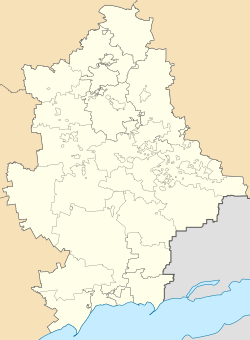
 Starobesheve Show map of Donetsk Oblast  Starobesheve Show map of Ukraine | ||
Coordinates: 47°45′11.44″N 38°1′53.86″E / 47.7531778°N 38.0316278°E / 47.7531778; 38.0316278Coordinates: 47°45′11.44″N 38°1′53.86″E / 47.7531778°N 38.0316278°E / 47.7531778; 38.0316278 | ||
| Country | ||
| Oblast | Donetsk Oblast | |
| Raion | Starobesheve Raion | |
| Founded | 1779 | |
| Population (2013) | ||
| • Total | 6,317 | |
| Time zone | UTC+2 (EET) | |
| • Summer (DST) | UTC+3 (EEST) | |
Starobesheve (Ukrainian: Старобешеве, Russian: Старобешево) is an urban-type settlement in the southeast of Donetsk Oblast, Ukraine. It is the administrative center of Starobesheve Raion. Starobesheve is located on the right bank of the Kalmius River,[1] about 20 kilometres (12 mi) northwest of the border with Russia. Population: 6,317 (2013 est.)[2].
Contents
1 History
2 Economy
2.1 Transportation
3 Culture and recreation
4 References
History
Starobeshevo was founded in 1779 as a selo of Beshevo by Greek settlers who moved from the settlement of Beshevo in Crimea, hence the name. During much of the 19th century, it belonged to Alexandrovsky Uyezd of Yekaterinoslav Governorate. In 1874, it was transferred to Mariupolsky Uyezd of the same governorate. After 1866, it was the administrative center of Beshevskaya Volost. In 1896, Beshevo was renamed Starobeshevo (Starobesheve, literally, Old Beshevo). In the beginning of the 20th century, the population of Beshevo was about 4000. [3]
Following the October Revolution, Soviet power was established in Starobesheve in January 1918. Between April and November the selo was occupied by German troops, and subsequently between December 1918 and May 1919 by the White Army. In May 1919, the Red Army occupied the locality.[3] In the mean time, in January 1919 Ukrainian Soviet Socialist Republic was established and Mariupolsky Uyezd was formally included in the republic, along with Starobesheve. In April 1920, the uyezd was transferred to the newly established Donetsk Governorate. On March 7, 1923 Styla Raion was established with its administrative center in the selo of Styla. Starobesheve was included in the raion. In November 1924, Starobesheve became the administrative center of the raion, and the raion was renamed Starobesheve.[4] On October 1, 1925 Donetsk Governorate was abolished, and Starobesheve was included in the newly established Mariupol Okruha, one of the okruhas into which Ukraine was divided. On July 2, 1932 Starobesheve was included in Donetsk Oblast. In 1936, the okruhas were abolished, and the raions were subordinated directly to the oblast.[5] During World War II, Starobesheve was occupied by German troops between October 1941 and September 1943.[3]
In 2014, during the War in Donbass, Starobesheve changed hands several times. Finally, it became controlled by the self-proclaimed Donetsk People's Republic.[6]
Economy
Transportation
Starobesheve is connected by road with Donetsk, with Novoazovsk and Mariupol via Telmanove, with Dokuchaievsk via Styla, with Amvrosiivka via Kuteinikove, with Novyi Svit, and with Mospyne.
Culture and recreation
Pasha Angelina, one of the first female tractor operators, was born and lived in Starobesheve and worked in the local kolkhoz. A memorial museum was open in the settlement.[3]
References
| Wikimedia Commons has media related to Starobeshevo. |
^ Starobesheve in the Great Soviet Encyclopedia, 1969–1978 (Russian)
^ "Чисельність наявного населення України (Actual population of Ukraine)" (in Ukrainian). State Statistics Service of Ukraine. Retrieved 21 January 2015..mw-parser-output cite.citation{font-style:inherit}.mw-parser-output q{quotes:"""""""'""'"}.mw-parser-output code.cs1-code{color:inherit;background:inherit;border:inherit;padding:inherit}.mw-parser-output .cs1-lock-free a{background:url("//upload.wikimedia.org/wikipedia/commons/thumb/6/65/Lock-green.svg/9px-Lock-green.svg.png")no-repeat;background-position:right .1em center}.mw-parser-output .cs1-lock-limited a,.mw-parser-output .cs1-lock-registration a{background:url("//upload.wikimedia.org/wikipedia/commons/thumb/d/d6/Lock-gray-alt-2.svg/9px-Lock-gray-alt-2.svg.png")no-repeat;background-position:right .1em center}.mw-parser-output .cs1-lock-subscription a{background:url("//upload.wikimedia.org/wikipedia/commons/thumb/a/aa/Lock-red-alt-2.svg/9px-Lock-red-alt-2.svg.png")no-repeat;background-position:right .1em center}.mw-parser-output .cs1-subscription,.mw-parser-output .cs1-registration{color:#555}.mw-parser-output .cs1-subscription span,.mw-parser-output .cs1-registration span{border-bottom:1px dotted;cursor:help}.mw-parser-output .cs1-hidden-error{display:none;font-size:100%}.mw-parser-output .cs1-visible-error{font-size:100%}.mw-parser-output .cs1-subscription,.mw-parser-output .cs1-registration,.mw-parser-output .cs1-format{font-size:95%}.mw-parser-output .cs1-kern-left,.mw-parser-output .cs1-kern-wl-left{padding-left:0.2em}.mw-parser-output .cs1-kern-right,.mw-parser-output .cs1-kern-wl-right{padding-right:0.2em}
^ abcd Ф. Д. Пиджарый; Н. П. Юрьев. Старобешево (in Russian). История городов и сёл Украины. Retrieved 29 August 2014.
^ Старобешевский район Донецкой области (in Russian). donbass-info. Retrieved 30 August 2014.
^ История Донецкой области (in Russian). donbass-info. Retrieved 30 August 2014.
^ http://www.radiosvoboda.org/a/27549232.html.
