Nagasaki Prefecture
Nagasaki Prefecture .mw-parser-output .nobold{font-weight:normal} 長崎県 | |||
|---|---|---|---|
Prefecture | |||
| Japanese transcription(s) | |||
| • Japanese | 長崎県 | ||
| • Rōmaji | Nagasaki-ken | ||
| |||
 | |||
| Country | Japan | ||
| Region | Kyushu | ||
| Island | Kyushu | ||
| Capital | Nagasaki | ||
| Government | |||
| • Governor | Hōdō Nakamura | ||
| Area | |||
| • Total | 4,105.47 km2 (1,585.13 sq mi) | ||
| Area rank | 37th | ||
| Population (2018) | |||
| • Total | 1,348,529 | ||
| • Rank | 26th | ||
| • Density | 326/km2 (840/sq mi) | ||
| ISO 3166 code | JP-42 | ||
| Districts | 4 | ||
| Municipalities | 21 | ||
| Flower | Unzentsutsuji (Rhododendron serpyllifolium) | ||
| Tree | Sawara (Chamaecyparis pisifera) | ||
| Bird | Mandarin duck (Aix galericulata) | ||
| Website | www.pref.nagasaki.jp/en | ||


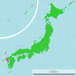
Nagasaki Prefecture (長崎県, Nagasaki-ken) is a prefecture of Japan located on the island of Kyushu.[1] The capital is the city of Nagasaki.[2]
Contents
1 History
2 Geography
2.1 Cities
2.2 Districts
2.3 Mergers
3 Culture
3.1 Religion
3.2 Sports
4 Tourism
5 Transportation
5.1 Rail
5.2 Tram
5.3 Roads
5.3.1 Expressways and toll roads
5.3.2 National highways
5.4 Ports
5.5 Airports
6 Politics
7 Notes
8 References
9 External links
History
Nagasaki Prefecture was created by merging of the western half of the former province of Hizen with the island provinces of Tsushima and Iki.[3] Facing China and Korea, the region around Hirado was a traditional center for traders and pirates.

Kuichi Uchida's image of Nagasaki in 1872
During the 16th century, Catholic missionaries and traders from Portugal arrived and became active in Hirado and Nagasaki, which became a major center for foreign trade. After being given free rein in Oda Nobunaga's period, the missionaries were forced out little by little, until finally, in the Tokugawa era, Christianity was banned under the Sakoku national isolation policy: Japanese foreign trade was restricted to Chinese and Dutch traders based at Dejima in Nagasaki. However, Kirishitan (Japanese Christian) worship continued underground. These Kakure Kirishitan (hidden Christians) were tried at every step, forced to step on fumi-e ("trample pictures", images of the Virgin Mary and saints) to prove that they were non-Christian. With the banishment of all Catholic missionaries, traders from Catholic countries were also forced out of the country. Along with them, their children, half Japanese and half European, were forced to leave. The majority was sent to Jagatara (Jakarta) and are still remembered by the locals as the people who wrote the poignant letters which were smuggled across the sea to their homeland.
Today, Nagasaki has prominent Catholic churches, and the Hidden Christian Sites in the Nagasaki Region, have been included on the UNESCO World Heritage List.

Nagasaki Prefect Office, Meiji Period
During the Meiji Restoration, Nagasaki and Sasebo became major ports for foreign trade, and eventually major military bases and shipbuilding centers for the Imperial Japanese Navy and the Mitsubishi Heavy Industries up to World War II. On August 9, 1945, the United States dropped an atomic bomb on Nagasaki, which destroyed all buildings in a 1.6 kilometres (1.0 mi) radius from the point of impact and extensively damaged other parts of the city. Roughly 39,000 people were killed, including 27,778 Japanese munitions workers, 2,000 Korean forced workers, and 150 Japanese soldiers. About 68-80% of the industrial production was destroyed to the point it would not recover for months or at least a year.
Nagasaki Prefecture contains many areas prone to heavy rain and landslide damage. In July 1957, mainly in the Isahaya area, damage from heavy rains, flooding and landslides lead to a death toll of 586, with 136 people missing and 3,860 injured. In July 1982, typhoon damage in the Nagasaki area lead to 299 fatalities, according to a report by the Japanese government.[citation needed]
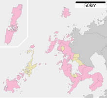
Geography
Nagasaki borders Saga Prefecture on the east, and is otherwise surrounded by water, including Ariake Bay, the Tsushima Straits (far from Busan and South Gyeongsang Province, South Korea), and the East China Sea. It also includes a large number of islands such as Tsushima and Iki. Most of the prefecture is near the coast and there are a number of ports such as Nagasaki and a United States Navy base at Sasebo.
As of 1 April 2014, 18% of the total land area of the prefecture was designated as Natural Parks, namely the Saikai and Unzen-Amakusa National Parks; Genkai and Iki-Tsushima Quasi-National Parks; and Hokushō, Nishi Sonogi Hantō, Nomo Hantō, Ōmurawan, Shimabara Hantō, and Taradake Prefectural Natural Parks.[4]
Cities
Map of Nagasaki Prefecture
City Town

Night view of Nagasaki City

Sasebo
Shimabara
Thirteen cities are located in Nagasaki Prefecture:
|
|
|
|
Districts
These are the towns and villages of each district:
|
|
|
|
Mergers
The following municipalities have been dissolved since the year 2000.
- Kitamatsuura District:
Emukae, Fukushima, Ikitsuki, Kosaza, Ōshima, Sechibaru, Shikamachi, Tabira, Takashima, Uku, Yoshii
- Minamimatsuura District:
Arikawa, Kamigotō, Kishiku, Miiraku, Narao, Naru, Shin'uonome, Tamanoura, Tomie, Wakamatsu
- Nishisonogi District:
Iōjima, Kinkai, Kōyagi, Nomozaki, Ōseto, Ōshima, Saikai, Sakito, Sanwa, Seihi, Sotome, Takashima, Tarami
Kitatakaki District:
Iimori, Konagai, Moriyama, Takaki
Minamitakaki District:
Aino, Ariake, Arie, Azuma, Chidiwa, Fukae, Futsu, Kazusa, Kitaarima, Kuchinotsu, Kunimi, Minamiarima, Minamikushiyama, Mizuho, Nishiarie, Obama
Kamiagata District:
Kamiagata, Kamitsushima, Mine
Shimoagata District:
Izuhara, Mitsushima, Toyotama
Iki District:
Ashibe, Gonoura, Ishida, Katsumoto
Culture
Religion
Nagasaki is the most Christianized area in Japan with Roman Catholic missions having been established there as early as the 16th century. Shusaku Endo's novel Silence draws from the oral history of the local Christian (Kirishitan) communities, both Kakure Kirishitan and Hanare Kirishitan.
As of 2002, there are 68,617 Catholics in Nagasaki Prefecture, accounting for 4.52 percent of the population of the prefecture.
Sports
The Nagasaki Saints of the Shikoku-Kyūshū Island League make Nagasaki Prefecture their home.
Tourism

Lighthouse at Osezaki in Gotō

Grave of William Adams in Hirado
Castle in Shimabara

Sōfuku-ji Ōbaku Zen temple in Nagasaki

Kujū-ku Islands in Sasebo
- Nagasaki (capital city)
- Ōura Church
- Urakami Cathedral
- Confucius Shrine, Nagasaki
- Glover Garden
- Nagasaki Shinchi Chinatown
- Mount Inasa
- Kōfuku-ji
- Sōfuku-ji
- Suwa Shrine
- Hirado
- Hirado Castle
- Sakikata Park
- Sasebo
- Kujū-ku Islands
- Huis Ten Bosch (theme park)
- Tenkaihō
- Saikai
- Nagasaki Bio Park
- Shimabara Peninsula
- Mount Unzen
- Shimabara Castle
Transportation
Rail
JR Kyushu
- Nagasaki Main Line
- Sasebo Line
- Omura Line
- Shimabara Railway
Matsuura Railway
- Nishi-Kyūshū Line
Tram
- Nagasaki Electric Tramway
Roads
Expressways and toll roads
- Nagasaki Expressway
- West Kyushu Expressway
- Nagasaki Dejima Road
- Kawahira Toll Road
- Kunimi Toll Road
- Kawahira Toll Road
National highways
- Route 34
- Route 35
- Route 57
- Route 202
- Route 204
- Route 205
- Route 206
- Route 207
- Route 251
- Route 324
- Route 382
- Route 383
- Route 384
- Route 389
- Route 444
- Route 498
- Route 499
Ports
- Nagasaki Port
- Sasebo Port
- Matsuura Port
- Hirado Port
- Shimabara Port
- Fukue Port
- Izuhara Port of Tsushima
- Gonoura Port of Iki Island
Airports
- Nagasaki Airport
- Fukue Airport
- Iki Airport
- Tsushima Airport
Politics
The current governor of Nagasaki is former vice-governor Hōdō Nakamura. First elected in 2010 to succeed Genjirō Kaneko, he was reelected for a second term in 2014.
The prefectural assembly of Nagasaki has a regular membership of 46, elected in 16 electoral districts in unified regional elections (last round: 2011). As of April 2014, the LDP-led caucus has 23 members, the DPJ-SDP-led caucus 17.
In the National Diet, Nagasaki is represented by four directly elected members of the House of Representatives and two (one per ordinary election) of the House of Councillors. After the most recent national elections of 2010, 2012 and 2013, Nagasaki sends an all-LDP delegation to the Diet (excluding members who lost election in Nagasaki districts, but were elected to the proportional representation segment of the House of Representatives in the Kyūshū block).
Notes
^ Nussbaum, Louis-Frédéric. (2005). "Nagasaki prefecture" in Japan Encyclopedia, p. 683, p. 683, at Google Books.
^ Nussbaum, "Nagasaki" in p. 683, p. 683, at Google Books.
^ Nussbaum, "Provinces and prefectures" in p. 780, p. 780, at Google Books.
^ "General overview of area figures for Natural Parks by prefecture" (PDF). Ministry of the Environment. 1 April 2014. Retrieved 8 February 2015..mw-parser-output cite.citation{font-style:inherit}.mw-parser-output q{quotes:"""""""'""'"}.mw-parser-output code.cs1-code{color:inherit;background:inherit;border:inherit;padding:inherit}.mw-parser-output .cs1-lock-free a{background:url("//upload.wikimedia.org/wikipedia/commons/thumb/6/65/Lock-green.svg/9px-Lock-green.svg.png")no-repeat;background-position:right .1em center}.mw-parser-output .cs1-lock-limited a,.mw-parser-output .cs1-lock-registration a{background:url("//upload.wikimedia.org/wikipedia/commons/thumb/d/d6/Lock-gray-alt-2.svg/9px-Lock-gray-alt-2.svg.png")no-repeat;background-position:right .1em center}.mw-parser-output .cs1-lock-subscription a{background:url("//upload.wikimedia.org/wikipedia/commons/thumb/a/aa/Lock-red-alt-2.svg/9px-Lock-red-alt-2.svg.png")no-repeat;background-position:right .1em center}.mw-parser-output .cs1-subscription,.mw-parser-output .cs1-registration{color:#555}.mw-parser-output .cs1-subscription span,.mw-parser-output .cs1-registration span{border-bottom:1px dotted;cursor:help}.mw-parser-output .cs1-hidden-error{display:none;font-size:100%}.mw-parser-output .cs1-visible-error{font-size:100%}.mw-parser-output .cs1-subscription,.mw-parser-output .cs1-registration,.mw-parser-output .cs1-format{font-size:95%}.mw-parser-output .cs1-kern-left,.mw-parser-output .cs1-kern-wl-left{padding-left:0.2em}.mw-parser-output .cs1-kern-right,.mw-parser-output .cs1-kern-wl-right{padding-right:0.2em}
References
- Nussbaum, Louis-Frédéric and Käthe Roth. (2005). Japan encyclopedia. Cambridge: Harvard University Press.
ISBN 978-0-674-01753-5; OCLC 58053128
External links
| Wikimedia Commons has media related to Nagasaki prefecture. |
- Official website
Nagasaki (capital) | |||||
| Core cities |
| ||||
| Cities |
| ||||
| Districts |
| ||||
List of mergers in Nagasaki Prefecture | |||||
| Regions |
|  | |||||||||||||||
|---|---|---|---|---|---|---|---|---|---|---|---|---|---|---|---|---|---|
| 47 Prefectures |
| ||||||||||||||||
Coordinates: 32°58′N 129°48′E / 32.967°N 129.800°E / 32.967; 129.800
Authority control |
|
|---|


