Montagnes District
Montagnes District District des Montagnes | |
|---|---|
District | |
 | |
| Country | |
| Established | 2011 |
| Capital | Man |
| Area [1] | |
| • Total | 31,050 km2 (11,990 sq mi) |
| Population (2014)[2] | |
| • Total | 2,371,920 |
| • Density | 76/km2 (200/sq mi) |
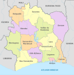
Montagnes District (French: District des Montagnes) is one of fourteen administrative districts of Ivory Coast. The district is located in the western part of the country, bordering Liberia and Guinea to the west, Woroba District to the north, Sassandra-Marahoué District to the east, and Bas-Sassandra District to the south.[1] The capital of the district is Man.
Contents
1 Creation
2 Administrative divisions
3 Population
4 References
Creation
Montagnes District was created in a 2011 administrative reorganisation of the subdivisions of Ivory Coast.[3] The territory of the district was composed by merging the former regions of Dix-Huit Montagnes and Moyen-Cavally.[1]
Administrative divisions
Montagnes District is currently subdivided into three regions and the following departments:
Cavally Region (region seat in Guiglo)
- Bloléquin Department
- Guiglo Department
- Toulépleu Department
- Taï Department
Guémon Region (region seat in Duékoué)
- Bangolo Department
- Duékoué Department
- Kouibly Department
- Facobly Department
Tonkpi Region (region seat also in Man)
- Biankouma Department
- Danané Department
- Man Department
- Zouan-Hounien Department
- Sipilou Department
Population
According to the 2014 census, Montagnes District has a population of 2,371,920, making it the second most populous district in Ivory Coast, behind only Abidjan Autonomous District.[2]
References
^ abc "Districts of Côte d'Ivoire (Ivory Coast)". Statoids.com. Retrieved 24 June 2015..mw-parser-output cite.citation{font-style:inherit}.mw-parser-output .citation q{quotes:"""""""'""'"}.mw-parser-output .citation .cs1-lock-free a{background:url("//upload.wikimedia.org/wikipedia/commons/thumb/6/65/Lock-green.svg/9px-Lock-green.svg.png")no-repeat;background-position:right .1em center}.mw-parser-output .citation .cs1-lock-limited a,.mw-parser-output .citation .cs1-lock-registration a{background:url("//upload.wikimedia.org/wikipedia/commons/thumb/d/d6/Lock-gray-alt-2.svg/9px-Lock-gray-alt-2.svg.png")no-repeat;background-position:right .1em center}.mw-parser-output .citation .cs1-lock-subscription a{background:url("//upload.wikimedia.org/wikipedia/commons/thumb/a/aa/Lock-red-alt-2.svg/9px-Lock-red-alt-2.svg.png")no-repeat;background-position:right .1em center}.mw-parser-output .cs1-subscription,.mw-parser-output .cs1-registration{color:#555}.mw-parser-output .cs1-subscription span,.mw-parser-output .cs1-registration span{border-bottom:1px dotted;cursor:help}.mw-parser-output .cs1-ws-icon a{background:url("//upload.wikimedia.org/wikipedia/commons/thumb/4/4c/Wikisource-logo.svg/12px-Wikisource-logo.svg.png")no-repeat;background-position:right .1em center}.mw-parser-output code.cs1-code{color:inherit;background:inherit;border:inherit;padding:inherit}.mw-parser-output .cs1-hidden-error{display:none;font-size:100%}.mw-parser-output .cs1-visible-error{font-size:100%}.mw-parser-output .cs1-maint{display:none;color:#33aa33;margin-left:0.3em}.mw-parser-output .cs1-subscription,.mw-parser-output .cs1-registration,.mw-parser-output .cs1-format{font-size:95%}.mw-parser-output .cs1-kern-left,.mw-parser-output .cs1-kern-wl-left{padding-left:0.2em}.mw-parser-output .cs1-kern-right,.mw-parser-output .cs1-kern-wl-right{padding-right:0.2em}
^ ab "Côte d'Ivoire". GeoHive.com. Retrieved 24 June 2015.
^ Décret n° 2011-263 du 28 septembre 2011 portant organisation du territoire national en Districts et en Régions.
Coordinates: 7°24′N 7°33′W / 7.400°N 7.550°W / 7.400; -7.550
