Barford St. Michael
| Barford St Michael | |
|---|---|
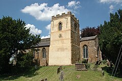 St Michael's parish church | |
 Barford St Michael Barford St Michael shown within Oxfordshire | |
| OS grid reference | SP4332 |
| Civil parish |
|
| District |
|
| Shire county |
|
| Region |
|
| Country | England |
| Sovereign state | United Kingdom |
| Post town | Banbury |
| Postcode district | OX15 |
| Dialling code | 01869 |
| Police | Thames Valley |
| Fire | Oxfordshire |
| Ambulance | South Central |
| EU Parliament | South East England |
| UK Parliament |
|
Barford St Michael is a village on the south bank of the River Swere in Oxfordshire, England, about 5 miles (8 km) south of Banbury.
History

North door of St Michael's church: Norman doorway within Gothic porch
The village is part of the civil parish of Barford St. John and St. Michael. Barford St Michael has sometimes been called Great Barford as it is much larger than the village of Barford St. John on the opposite bank of the Swere.[1]
The bell tower and north doorway of Church of England parish church of St Michael are Norman. Much of the rest of the church was rebuilt in the 13th century in the Early English Gothic style.[2] It is a Grade I listed building.[3]
In August 1549 the vicar, James Webbe, was executed at Aylesbury for his part in leading a rising in protest at the abolition of the Latin liturgy and other religious reforms.[4]
The village has one public house, the George Inn. It was built in 1697[5] and in the 20th century was a Hunt Edmunds tied house. There is also a farm shop. Woodworm Records Recording Studio is based in the village.
References

The George Inn
^ Crossley, Alan (ed.); Baggs, AP; Colvin, Christina; Colvin, HM; Cooper, Janet; Day, CJ; Selwyn, Nesta; Tomkinson, A (1983). A History of the County of Oxford. Victoria County History. 11: Wootton Hundred (northern part). London: Oxford University Press for the Institute of Historical Research. pp. 45–58. ISBN 978-0-19722-758-9.CS1 maint: Extra text: authors list (link).mw-parser-output cite.citation{font-style:inherit}.mw-parser-output .citation q{quotes:"""""""'""'"}.mw-parser-output .citation .cs1-lock-free a{background:url("//upload.wikimedia.org/wikipedia/commons/thumb/6/65/Lock-green.svg/9px-Lock-green.svg.png")no-repeat;background-position:right .1em center}.mw-parser-output .citation .cs1-lock-limited a,.mw-parser-output .citation .cs1-lock-registration a{background:url("//upload.wikimedia.org/wikipedia/commons/thumb/d/d6/Lock-gray-alt-2.svg/9px-Lock-gray-alt-2.svg.png")no-repeat;background-position:right .1em center}.mw-parser-output .citation .cs1-lock-subscription a{background:url("//upload.wikimedia.org/wikipedia/commons/thumb/a/aa/Lock-red-alt-2.svg/9px-Lock-red-alt-2.svg.png")no-repeat;background-position:right .1em center}.mw-parser-output .cs1-subscription,.mw-parser-output .cs1-registration{color:#555}.mw-parser-output .cs1-subscription span,.mw-parser-output .cs1-registration span{border-bottom:1px dotted;cursor:help}.mw-parser-output .cs1-ws-icon a{background:url("//upload.wikimedia.org/wikipedia/commons/thumb/4/4c/Wikisource-logo.svg/12px-Wikisource-logo.svg.png")no-repeat;background-position:right .1em center}.mw-parser-output code.cs1-code{color:inherit;background:inherit;border:inherit;padding:inherit}.mw-parser-output .cs1-hidden-error{display:none;font-size:100%}.mw-parser-output .cs1-visible-error{font-size:100%}.mw-parser-output .cs1-maint{display:none;color:#33aa33;margin-left:0.3em}.mw-parser-output .cs1-subscription,.mw-parser-output .cs1-registration,.mw-parser-output .cs1-format{font-size:95%}.mw-parser-output .cs1-kern-left,.mw-parser-output .cs1-kern-wl-left{padding-left:0.2em}.mw-parser-output .cs1-kern-right,.mw-parser-output .cs1-kern-wl-right{padding-right:0.2em}
^ Sherwood, Jennifer; Pevsner, Nikolaus (1974). Oxfordshire. The Buildings of England. Harmondsworth: Penguin Books. pp. 445–446. ISBN 0-14-071045-0.
^ "Church of St Michael". National Heritage List for England. English Heritage. 8 December 1955. Retrieved 11 September 2013.
^ Woodman, A. Vere (1957). "The Buckinghamshire and Oxfordshire Rising of 1549" (PDF). Oxoniensia. XXII: 82–83.
^ "George Inn, Lower Street". National Heritage List for England. English Heritage. 8 December 1955. Retrieved 11 September 2013.
External links
| Wikimedia Commons has media related to Barford St. Michael. |
Barford [St Michael] in the Domesday Book
The District of Cherwell | ||
|---|---|---|
| ||
| Towns |
|  |
| Large villages |
| |
| Other civil parishes (component villages and hamlets) |
| |
| Former districts and boroughs |
| |
| Former constituencies |
| |
| ||
This Oxfordshire location article is a stub. You can help Wikipedia by expanding it. |


