Toa Alta, Puerto Rico
Toa Alta, Puerto Rico | |||
|---|---|---|---|
Municipality | |||
 | |||
| |||
| Nickname(s): "La Ciudad del Toa", "Cuna de Poetas", "Ciudad del Josco" | |||
| Motto(s): "Todo un Pueblo" | |||
| Anthem: "Cuna de historia y de grandes poetas" | |||
 Location of Toa Alta in Puerto Rico | |||
| Coordinates: 18°23′18″N 66°14′54″W / 18.38833°N 66.24833°W / 18.38833; -66.24833Coordinates: 18°23′18″N 66°14′54″W / 18.38833°N 66.24833°W / 18.38833; -66.24833 | |||
| Sovereign State | United States | ||
| Founded | 1751 | ||
| Government | |||
| • Mayor | Hon. Clemente "Chito" Agosto (PPD) | ||
| • Senatorial dist. | 2 - Bayamón | ||
| • Representative dist. | 11 | ||
| Area | |||
| • Total | 27.44 sq mi (71.08 km2) | ||
| • Land | 27.37 sq mi (70.88 km2) | ||
| • Water | 0.08 sq mi (0.20 km2) | ||
| Elevation | 236 ft (72 m) | ||
| Population (2010) | |||
| • Total | 74,066 | ||
| • Density | 2,700/sq mi (1,000/km2) | ||
| Demonym(s) | Toalteños | ||
| Time zone | UTC−4 (AST) | ||
| Zip code | 00953, 00954 | ||
| Area code | +1 (spec. +1-787 and +1-939) | ||
| Website | Toa Alta, Puerto Rico | ||


Toa Alta (Spanish pronunciation: [ˈtoa ˈalta]) is a municipality of Puerto Rico (U.S.) located in the northern coast of the island, north of Naranjito; south of Dorado and Toa Baja; east of Vega Alta and Corozal; and west of Bayamón. Toa Alta is spread over eight wards and Toa Alta Pueblo (the downtown area and the administrative center of the city). It is part of the San Juan-Caguas-Guaynabo Metropolitan Statistical Area.[1]
Contents
1 History
2 Geography
2.1 Barrios
3 Tourism
3.1 Landmarks and places of interest
4 Culture
4.1 Festivals and events
5 Government
6 Symbols
6.1 Flag
6.2 Coat of arms
7 Education
7.1 Elementary schools
7.2 Middle and junior high schools
7.3 High schools
7.4 Private schools
8 Notable natives and residents
9 See also
10 References
11 External links
History
Toa Alta located west of the capital city of San Juan, the town was founded in 1751 making it one of the oldest towns on the Island. The construction of the San Fernando Rey church in the town square began in 1752. The name Toa Alta comes from the Taino word for valley, "Thoa". Over the years, agriculture became an important economic force in the area. At the peak of the agricultural economy, the town was also known as the "Granja de los Reyes Católicos" (the Farm of the Catholic Monarchs). The town is also called "Ciudad del Josco". The town is commonly known by its nickname "La Cuna de los Poetas," or "Cradle of Poets," due to the numerous Spanish-language poets who were born there, such as Abelardo Diaz Alfaro and the musician Tomás "Masso" Rivera.
Geography
Toa Alta Northern Coastal Plain and to the karst zone.
Barrios
Like all municipalities of Puerto Rico, Toa Alta is subdivided into barrios.[2][3][4][5]
- Contorno
- Galateo
- Mucarabones
- Ortíz
- Piñas
- Quebrada Arenas
- Quebrada Cruz
- Río Lajas
- Toa Alta Pueblo
Tourism
Landmarks and places of interest
- Legendary Tree "Bala de Cañón"
- Tomas "Maso" Rivera Municipal Teather
- Tomas "Maso" Rivera Statue
- Plaza Recreo Egozcué
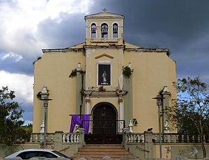
- San Fernando Rey Parish
- Villa Tropical Recreation Center
- Plaza Aquarium Mall
- Valle "El Toa"
Culture
Festivals and events
- Chopa Marathon - March
- Festival de Bellas Artes - April
- Patron Celebrations - May
- Typical Music - November
Government
Like all municipalities in Puerto Rico, Toa Alta is administered by a mayor. The current mayor is Clemente Agosto, from the Popular Democratic Party (PPD). Agosto was elected at the 2012 general election.
The city belongs to the Puerto Rico Senatorial district II, which is represented by two Senators. Migdalia Padilla and Carmelo Ríos Santiago have served as District Senators since 2005.[6]
Symbols
Flag
Horizontally divided in three, the bottom and top red stripes double the size of the center yellow stripe. In the upper left corner a yellow eight point star. The original design was elaborated by professor Herman E. Perez and adopted by the City Council in 1983
Coat of arms
The shield in gold, a red board with a silver sword topped with a gold crown of the same metal, to each side two small shields in red, the right-hand one with a tower in gold and the left-hand one with a gold eight point star, a five tower crown lined in black with red openings. Motto: Non Deserit Alta. Prof. Herman E Pérez included in the Coat of Arm this motto so that the present and future generations will remember: “not abandon higher principles and values”
Education
Toa Alta counts with several public and private schools distributed through several regions. Public education is handled by the Puerto Rico Department of Education.[7]
Elementary schools
- Alejandro Junior Cruz
- Heraclio Rivera Colón
- José de Diego
- José María del Valle
- Luis Muñoz Rivera
- Manuel Velilla
- María C. Osorio
- Merced Marcano
- Secundino Díaz
- Violanta Jiménez
- Virgilio Morales
Middle and junior high schools
- José Pablo Morales
- Abelardo Díaz Alfaro
- Felipe Díaz González
High schools
- Adela Rolón Fuentes
- Nicolás Sevilla
- Tomás "Maso" Rivera Morales
Private schools
- Academia Cristiana Yarah
- Colegio Doriber
Notable natives and residents
- Sergeants Jose Díaz and Francisco Diaz - defended Puerto Rico from a British invasion in 1797
Dayanara Torres Delgado - Miss Universe 1993
Yarelis Salgado – model and actress
See also
- List of Puerto Ricans
- History of Puerto Rico
- Did you know-Puerto Rico?
References
^ Gobierno de Puerto Rico - Toa Alta, Puerto Rico
^ Picó, Rafael; Buitrago de Santiago, Zayda; Berrios, Hector H. Nueva geografía de Puerto Rico: física, económica, y social, por Rafael Picó. Con la colaboración de Zayda Buitrago de Santiago y Héctor H. Berrios. San Juan Editorial Universitaria, Universidad de Puerto Rico,1969..mw-parser-output cite.citation{font-style:inherit}.mw-parser-output q{quotes:"""""""'""'"}.mw-parser-output code.cs1-code{color:inherit;background:inherit;border:inherit;padding:inherit}.mw-parser-output .cs1-lock-free a{background:url("//upload.wikimedia.org/wikipedia/commons/thumb/6/65/Lock-green.svg/9px-Lock-green.svg.png")no-repeat;background-position:right .1em center}.mw-parser-output .cs1-lock-limited a,.mw-parser-output .cs1-lock-registration a{background:url("//upload.wikimedia.org/wikipedia/commons/thumb/d/d6/Lock-gray-alt-2.svg/9px-Lock-gray-alt-2.svg.png")no-repeat;background-position:right .1em center}.mw-parser-output .cs1-lock-subscription a{background:url("//upload.wikimedia.org/wikipedia/commons/thumb/a/aa/Lock-red-alt-2.svg/9px-Lock-red-alt-2.svg.png")no-repeat;background-position:right .1em center}.mw-parser-output .cs1-subscription,.mw-parser-output .cs1-registration{color:#555}.mw-parser-output .cs1-subscription span,.mw-parser-output .cs1-registration span{border-bottom:1px dotted;cursor:help}.mw-parser-output .cs1-hidden-error{display:none;font-size:100%}.mw-parser-output .cs1-visible-error{font-size:100%}.mw-parser-output .cs1-subscription,.mw-parser-output .cs1-registration,.mw-parser-output .cs1-format{font-size:95%}.mw-parser-output .cs1-kern-left,.mw-parser-output .cs1-kern-wl-left{padding-left:0.2em}.mw-parser-output .cs1-kern-right,.mw-parser-output .cs1-kern-wl-right{padding-right:0.2em}
^ Gwillim Law (20 May 2015). Administrative Subdivisions of Countries: A Comprehensive World Reference, 1900 through 1998. McFarland. p. 300. ISBN 978-1-4766-0447-3. Retrieved 25 December 2018.
^ Puerto Rico:2010:population and housing unit counts.pdf (PDF). U.S. Dept. of Commerce, Economics and Statistics Administration, U.S. Census Bureau. 2010.
^ "Map of Toa Alta at the Wayback Machine" (PDF). Retrieved 2018-12-29.
^ Elecciones Generales 2008: Escrutinio General Archived 2011-11-20 at the Wayback Machine. on CEEPUR
^ Educacion - Toa Alta, Puerto Rico
External links
- Toa Alta and its barrios, United States Census Bureau
- Welcome to Puerto Rico! Toa Alta
San Juan (capital) | |
| Metropolitan areas |
|
| Municipalities |
|
| Islands |
|
| Geography |
|


