Oriental (Morocco)
The Oriental Region
| |
|---|---|
Region | |
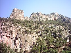 Jebel Tamejout - Grotte du Chameau (Zegzel) | |
 | |
| Coordinates: 34°41′N 1°54′W / 34.683°N 1.900°W / 34.683; -1.900Coordinates: 34°41′N 1°54′W / 34.683°N 1.900°W / 34.683; -1.900 | |
| Country | |
| Capital | Oujda |
| Government | |
| • Wali (Governor) | Mohamed Mhidia |
| • President | Abdenbi Bioui |
| Area | |
| • Total | 90,127 km2 (34,798 sq mi) |
| Population (2014) | |
| • Total | 2,314,346 |
| Time zone | UTC+0 (WET) |
| • Summer (DST) | UTC+1 (WEST) |
Oriental (Berber: Tagmuḍant, ⵜⴰⴳⵎⵓⴹⴰⵏⵜ; Arabic: الشرق, Ash-Sharq) is one of the twelve regions of Morocco, located in the eastern part of the country. It covers an area of 90,127 km² and has a population of 2,314,346 (2014 census).
The capital and the largest city is Oujda, and the second largest city is Nador. The region includes 7 provinces and one prefecture. Mohamed Mhidia became wali (governor) of the region in 2015.[1]
A majority of the population of Oriental speak Moroccan Darija Arabic (86.2%) as a first or second language. A large minority speak the Rif-Berber language (38.4%) as a first language. Small numbers speak Eastern Middle Atlas Tamazight and Figuig Tamazight, principally in the south of Oriental.[2]
Contents
1 Etymology
2 Geography
3 Municipalities by population (2014)
4 References
5 External links
Etymology
The English name Oriental is derived from the French term L'Oriental (for "the east") and comes directly from the Latin orientalis, "of the east", being that the region is located in the east of Morocco.[3] The Arabic name Ash-Sharq also means "the east", as does the Berber name Tagmuḍant (from agmuḍan).
Geography
Oriental is situated in the eastern part of the country, with a northern coastline on the Mediterranean Sea. The regions of Taza-Al Hoceima-Taounate, Fès-Boulemane and Meknès-Tafilalet lie to its west, with the Algerian provinces of Tlemcen and Naâma to its east and Béchar to the south. Melilla, a Spanish autonomous city, also borders the region. In 2015, Oriental was expanded to include Guercif Province.
The region is made up into the following prefectures and provinces:[4]
- Berkane Province
- Driouch Province
- Figuig Province
- Guercif Province
- Jerada Province
- Nador Province
- Oujda-Angad Prefecture
- Taourirt Province
Municipalities by population (2014)

Main square of Oujda, the regional capital and largest city.
| Name | Province/Prefecture | Population (2014) |
|---|---|---|
| Oujda | Oujda-Angad | 494,252 |
| Nador | Nador Province | 161,726 |
| Berkane | Berkane Province | 109,237 |
| Taourirt | Taourirt Province | 103,398 |
| Beni Ensar / Aït Nsar | Nador Province | 56,582 |
| Al Aaroui | Nador Province | 47,599 |
| Jerada | Jerada Province | 43,506 |
| El Aioun Sidi Mellouk | Taourirt Province | 41,832 |
| Bouarg | Nador Province | 37,737 |
| Zaio | Nador Province | 35,806 |
| Zeghanghane | Nador Province | 34,025 |
| Sidi Slimane Echcharraa | Berkane Province | 30,202 |
| Bouarfa | Figuig Province | 28,846 |
| Bni Chiker | Nador Province | 26,884 |
| Oulad Settout | Nador Province | 23,218 |
| Selouane | Nador Province | 21,570 |
| Boughriba | Berkane Province | 20,513 |
| Ahfir | Berkane Province | 19,630 |
| Arekmane | Nador Province | 18,490 |
| Mtalssa | Driouch Province | 16,787 |
| Talsint | Figuig Province | 16,166 |
| Bni Tadjite | Figuig Province | 16,149 |
| Zegzel | Berkane Province | 16,137 |
| Tendrara | Figuig Province | 15,390 |
| Midar | Driouch Province | 15,021 |
| Driouch | Driouch Province | 14,741 |
| Ben Taieb | Driouch Province | 14,257 |
| Temsamane | Driouch Province | 13,920 |
| Ain Bni Mathar | Jerada Province | 13,526 |
| Figuig | Figuig Province | 12,516 |
[5]
References
^ "Installation de Mohamed Mhidia, wali de la région de l'Oriental". 21 Oct 2015. Retrieved 23 Dec 2016..mw-parser-output cite.citation{font-style:inherit}.mw-parser-output q{quotes:"""""""'""'"}.mw-parser-output code.cs1-code{color:inherit;background:inherit;border:inherit;padding:inherit}.mw-parser-output .cs1-lock-free a{background:url("//upload.wikimedia.org/wikipedia/commons/thumb/6/65/Lock-green.svg/9px-Lock-green.svg.png")no-repeat;background-position:right .1em center}.mw-parser-output .cs1-lock-limited a,.mw-parser-output .cs1-lock-registration a{background:url("//upload.wikimedia.org/wikipedia/commons/thumb/d/d6/Lock-gray-alt-2.svg/9px-Lock-gray-alt-2.svg.png")no-repeat;background-position:right .1em center}.mw-parser-output .cs1-lock-subscription a{background:url("//upload.wikimedia.org/wikipedia/commons/thumb/a/aa/Lock-red-alt-2.svg/9px-Lock-red-alt-2.svg.png")no-repeat;background-position:right .1em center}.mw-parser-output .cs1-subscription,.mw-parser-output .cs1-registration{color:#555}.mw-parser-output .cs1-subscription span,.mw-parser-output .cs1-registration span{border-bottom:1px dotted;cursor:help}.mw-parser-output .cs1-hidden-error{display:none;font-size:100%}.mw-parser-output .cs1-visible-error{font-size:100%}.mw-parser-output .cs1-subscription,.mw-parser-output .cs1-registration,.mw-parser-output .cs1-format{font-size:95%}.mw-parser-output .cs1-kern-left,.mw-parser-output .cs1-kern-wl-left{padding-left:0.2em}.mw-parser-output .cs1-kern-right,.mw-parser-output .cs1-kern-wl-right{padding-right:0.2em}
^ "Population selon les langues nationales par régions en 2014 (%)". 13 Oct 2015. p. 30. Archived from the original on 22 October 2015. Retrieved 23 Dec 2016.
^ "Online Etymology Dictionary". www.etymonline.com. Douglas Harper. Retrieved 21 September 2015.
^ "Décret fixant le nom des régions" (PDF). Portail National des Collectivités Territoriales (in French). Archived from the original (pdf) on 2015-05-18. Retrieved 2015-07-11.
^ "Recensement général de la population et de l'habitat 2014". Hcp.ma. Archived from the original on 2015-09-14. Retrieved 2015-09-14.
External links
- Oriental web portal in French
- Oujda entry in lexicorient
- Figuig in English, French and Arab
Capital: Oujda | ||
| Provinces |
|  |
| Cities |
| |
Regions of Morocco | ||
|---|---|---|
| from 2015 |
| |
| 1997-2015 |
| |
| 1971-1997 |
| |
Regions falling partly (*) or entirely (**) within the disputed territory of Western Sahara | ||


