Roxbury, New Hampshire
| Roxbury, New Hampshire | |
|---|---|
| Town | |
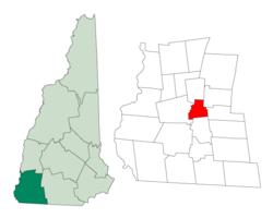 Location in Cheshire County, New Hampshire | |
| Coordinates: 42°57′18″N 72°12′21″W / 42.95500°N 72.20583°W / 42.95500; -72.20583Coordinates: 42°57′18″N 72°12′21″W / 42.95500°N 72.20583°W / 42.95500; -72.20583 | |
| Country | United States |
| State | New Hampshire |
| County | Cheshire |
| Incorporated | 1812 |
| Village | Roxbury Center |
| Government | |
| • Board of Selectmen | James Rousmaniere Tim O'Brien Mark Funk |
| Area | |
| • Total | 12.2 sq mi (31.6 km2) |
| • Land | 11.9 sq mi (30.8 km2) |
| • Water | 0.3 sq mi (0.8 km2) 2.38% |
| Elevation | 1,375 ft (419 m) |
| Population (2010) | |
| • Total | 229 |
| • Density | 19/sq mi (7.2/km2) |
| Time zone | UTC-5 (Eastern) |
| • Summer (DST) | UTC-4 (Eastern) |
| ZIP code | 03431 |
| Area code(s) | 603 |
| FIPS code | 33-65700 |
GNIS feature ID | 0873710 |
| Website | www.roxburynh.org |
Roxbury is a town in Cheshire County, New Hampshire, United States. The population was 229 at the 2010 census.[1]
Contents
1 History
2 Geography
3 Demographics
4 Notable people
5 References
6 External links
History
The smallest town in Cheshire County, Roxbury was incorporated in 1812 from portions of Nelson, Marlborough, and Keene. By then, settlers had established agriculture among the rolling hillsides in the area, and a community center had developed at what is now called Roxbury Center. It was a "hill farm" community with some scattered small mills. Roxbury's granite quarries, among the most extensive in the Granite State at the time, provided some of the stone for the capitol building of New York in Albany. Much of Roxbury was abandoned in the American Civil War as a very high percentage of its male population was killed in battle. Other residents left after the Civil War to seek a better life in local mill villages or in the American Midwest. Otter Brook Lake, constructed by the Army Corps of Engineers in 1956-58 to control flooding in the Ashuelot and Connecticut River valleys, occupies part of the town's western boundary.
Geography
According to the United States Census Bureau, the town has a total area of 12.2 square miles (31.6 km2), of which 11.9 sq mi (30.8 km2) is land and 0.3 sq mi (0.8 km2) is water, comprising 2.38% of the town. The highest point in Roxbury is the summit Bassett Hill, at 1,644 feet (501 m) above sea level.
Granite Gorge Ski Area on Pinnacle Mountain is located in the town's northwest corner along New Hampshire Route 9, despite being advertised as being in the neighboring city of Keene.
Batcheller's Cave is noted for its place in history as the hiding place of Breed Batcheller, who was edged out of town for failing to join the rebellion against the crown in the Revolutionary War.[2]
Demographics
| Historical population | |||
|---|---|---|---|
| Census | Pop. | %± | |
| 1820 | 366 | — | |
| 1830 | 322 | −12.0% | |
| 1840 | 286 | −11.2% | |
| 1850 | 260 | −9.1% | |
| 1860 | 212 | −18.5% | |
| 1870 | 174 | −17.9% | |
| 1880 | 126 | −27.6% | |
| 1890 | 129 | 2.4% | |
| 1900 | 100 | −22.5% | |
| 1910 | 66 | −34.0% | |
| 1920 | 56 | −15.2% | |
| 1930 | 53 | −5.4% | |
| 1940 | 113 | 113.2% | |
| 1950 | 117 | 3.5% | |
| 1960 | 137 | 17.1% | |
| 1970 | 161 | 17.5% | |
| 1980 | 190 | 18.0% | |
| 1990 | 248 | 30.5% | |
| 2000 | 237 | −4.4% | |
| 2010 | 229 | −3.4% | |
| Est. 2017 | 220 | [3] | −3.9% |
| U.S. Decennial Census[4] | |||
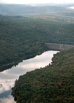
Otter Brook Lake in Roxbury
At the 2000 census,[5] there were 237 people, 89 households and 66 families residing in the town. The population density was 19.9 per square mile (7.7/km²). There were 90 housing units at an average density of 7.6 per square mile (2.9/km²). The racial makeup of the town was 98.73% White, 0.42% Asian, and 0.84% from two or more races.
There were 89 households of which 32.6% had children under the age of 18 living with them, 67.4% were married couples living together, 6.7% had a female householder with no husband present, and 25.8% were non-families. 20.2% of all households were made up of individuals and 5.6% had someone living alone who was 65 years of age or older. The average household size was 2.66 and the average family size was 3.12.
25.3% of the population were under the age of 18, 3.8% from 18 to 24, 28.7% from 25 to 44, 32.9% from 45 to 64, and 9.3% who were 65 years of age or older. The median age was 41 years. For every 100 females, there were 99.2 males. For every 100 females age 18 and over, there were 88.3 males.
The median household income was $49,375 and the median family income was $56,875. Males had a median income of $33,984 and females $23,750. The per capita income for the town was $21,124. None of the families and 0.9% of the population were living below the poverty line.
Notable people
Joseph Alexander Ames, artist
Nathan Ames, patent solicitor
Breed Batcheller, major early landowner and settler, and later in hiding at Batcheller's Cave
Maynard T. Parker, Wisconsin jurist and legislator
Cyrus Wakefield, manufacturer of rattan furniture
References
^ United States Census Bureau, American FactFinder, 2010 Census figures. Retrieved March 23, 2011.
^ "History of Roxbury". Town of Roxbury - A good dam town. Town of Roxbury. Retrieved 28 October 2015..mw-parser-output cite.citation{font-style:inherit}.mw-parser-output q{quotes:"""""""'""'"}.mw-parser-output code.cs1-code{color:inherit;background:inherit;border:inherit;padding:inherit}.mw-parser-output .cs1-lock-free a{background:url("//upload.wikimedia.org/wikipedia/commons/thumb/6/65/Lock-green.svg/9px-Lock-green.svg.png")no-repeat;background-position:right .1em center}.mw-parser-output .cs1-lock-limited a,.mw-parser-output .cs1-lock-registration a{background:url("//upload.wikimedia.org/wikipedia/commons/thumb/d/d6/Lock-gray-alt-2.svg/9px-Lock-gray-alt-2.svg.png")no-repeat;background-position:right .1em center}.mw-parser-output .cs1-lock-subscription a{background:url("//upload.wikimedia.org/wikipedia/commons/thumb/a/aa/Lock-red-alt-2.svg/9px-Lock-red-alt-2.svg.png")no-repeat;background-position:right .1em center}.mw-parser-output .cs1-subscription,.mw-parser-output .cs1-registration{color:#555}.mw-parser-output .cs1-subscription span,.mw-parser-output .cs1-registration span{border-bottom:1px dotted;cursor:help}.mw-parser-output .cs1-hidden-error{display:none;font-size:100%}.mw-parser-output .cs1-visible-error{font-size:100%}.mw-parser-output .cs1-subscription,.mw-parser-output .cs1-registration,.mw-parser-output .cs1-format{font-size:95%}.mw-parser-output .cs1-kern-left,.mw-parser-output .cs1-kern-wl-left{padding-left:0.2em}.mw-parser-output .cs1-kern-right,.mw-parser-output .cs1-kern-wl-right{padding-right:0.2em}
^ "Annual Estimates of the Resident Population: April 1, 2010 to July 1, 2017 (PEPANNRES): Minor Civil Divisions – New Hampshire". Retrieved November 14, 2018.
^ "Census of Population and Housing". Census.gov. Retrieved June 4, 2016.
^ "American FactFinder". United States Census Bureau. Retrieved 2008-01-31.
External links
- Town of Roxbury official website
- New Hampshire Economic and Labor Market Information Bureau Profile
Places adjacent to Roxbury, New Hampshire | ||||||||||
|---|---|---|---|---|---|---|---|---|---|---|
| ||||||||||
Municipalities and communities of Cheshire County, New Hampshire, United States | ||
|---|---|---|
County seat: Keene | ||
| City |
|  |
| Towns |
| |
| CDPs |
| |
| Other villages |
| |


