Mount Hakone
| Mount Hakone | |
|---|---|
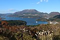
 Hakone volcano from the SW. | |
| Highest point | |
| Elevation | 1,438 metres (4,718 ft) |
| Coordinates | 35°13′48″N 139°01′26″E / 35.230°N 139.024°E / 35.230; 139.024Coordinates: 35°13′48″N 139°01′26″E / 35.230°N 139.024°E / 35.230; 139.024[1] |
| Naming | |
| Native name | 箱根山 |
| Geography | |
| Location | Hakone, Kanagawa, Honshu |
| Geology | |
| Mountain type | Complex calderas |
| Last eruption | June to July 2015[1] |
Mount Hakone (箱根山, Hakoneyama) is a complex volcano in Kanagawa Prefecture, Japan that is truncated by two overlapping calderas, the largest of which is 10 × 11 km wide. The calderas were formed as a result of two major explosive eruptions about 180,000 and 49,000–60,000 years ago. Lake Ashi lies between the southwestern caldera wall and a half dozen post-caldera lava domes that arose along a southwest–northeastern trend cutting through the center of the calderas. Dome growth occurred progressively to the south, and the largest and youngest of them, Kami-yama, forms the high point of Hakone. The calderas are breached to the east by the Haya-kawa canyon. Mount Ashigara is a parasitic cone.[1]
The latest magmatic eruptive activity at Hakone occurred 2,900 years ago. It produced a pyroclastic flow and a lava dome in the explosion crater, although phreatic eruptions took place as recently as the 12–13th centuries AD.[1]
According to the nearby Hakone Shrine, the Komagatake peak has been the object of religious veneration since ancient times.[2]
Gallery

Topographic map
Central cones of Hakone volcano
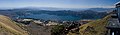
Lake Ashi viewed from central cone Mt.Komagatake lava dome.


Notes
^ abcd "Hakoneyama". Global Volcanism Program. Smithsonian Institution. Retrieved 2015-05-07..mw-parser-output cite.citation{font-style:inherit}.mw-parser-output .citation q{quotes:"""""""'""'"}.mw-parser-output .citation .cs1-lock-free a{background:url("//upload.wikimedia.org/wikipedia/commons/thumb/6/65/Lock-green.svg/9px-Lock-green.svg.png")no-repeat;background-position:right .1em center}.mw-parser-output .citation .cs1-lock-limited a,.mw-parser-output .citation .cs1-lock-registration a{background:url("//upload.wikimedia.org/wikipedia/commons/thumb/d/d6/Lock-gray-alt-2.svg/9px-Lock-gray-alt-2.svg.png")no-repeat;background-position:right .1em center}.mw-parser-output .citation .cs1-lock-subscription a{background:url("//upload.wikimedia.org/wikipedia/commons/thumb/a/aa/Lock-red-alt-2.svg/9px-Lock-red-alt-2.svg.png")no-repeat;background-position:right .1em center}.mw-parser-output .cs1-subscription,.mw-parser-output .cs1-registration{color:#555}.mw-parser-output .cs1-subscription span,.mw-parser-output .cs1-registration span{border-bottom:1px dotted;cursor:help}.mw-parser-output .cs1-ws-icon a{background:url("//upload.wikimedia.org/wikipedia/commons/thumb/4/4c/Wikisource-logo.svg/12px-Wikisource-logo.svg.png")no-repeat;background-position:right .1em center}.mw-parser-output code.cs1-code{color:inherit;background:inherit;border:inherit;padding:inherit}.mw-parser-output .cs1-hidden-error{display:none;font-size:100%}.mw-parser-output .cs1-visible-error{font-size:100%}.mw-parser-output .cs1-maint{display:none;color:#33aa33;margin-left:0.3em}.mw-parser-output .cs1-subscription,.mw-parser-output .cs1-registration,.mw-parser-output .cs1-format{font-size:95%}.mw-parser-output .cs1-kern-left,.mw-parser-output .cs1-kern-wl-left{padding-left:0.2em}.mw-parser-output .cs1-kern-right,.mw-parser-output .cs1-kern-wl-right{padding-right:0.2em}
^ "御際神、由緒、例祭日" [Gods worshipped, origins, ceremony days] (in Japanese). Hakone Shrine. Retrieved 7 December 2017.
External links
| Wikimedia Commons has media related to Hakone Mountains. |
Hakoneyama - Japan Meteorological Agency (in Japanese)
"Hakoneyama: National catalogue of the active volcanoes in Japan" (PDF). - Japan Meteorological Agency
Hakone Volcano Group - Geological Survey of Japan
Hakoneyama: Global Volcanism Program - Smithsonian Institution
Hakone Geopark(in Japanese)
Authority control |
|
|---|


