Madison County, North Carolina
Madison County, North Carolina | ||
|---|---|---|
 Madison County Courthouse in Marshall | ||
| ||
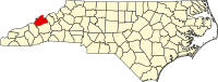 Location within the U.S. state of North Carolina | ||
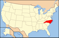 North Carolina's location within the U.S. | ||
| Founded | 1851 | |
| Named for | James Madison | |
| Seat | Marshall | |
| Largest town | Mars Hill | |
| Area | ||
| • Total | 451 sq mi (1,168 km2) | |
| • Land | 450 sq mi (1,165 km2) | |
| • Water | 1.9 sq mi (5 km2), 0.4% | |
| Population | ||
| • (2010) | 20,764 | |
| • Density | 46/sq mi (18/km2) | |
| Congressional district | 11th | |
| Time zone | Eastern: UTC−5/−4 | |
| Website | www.madisoncountync.org | |


Advertisement for Warm Springs Hotel, Madison County, ca. 1880
Madison County is a county located in the U.S. state of North Carolina. As of the 2010 census, the population was 20,764.[1] Its county seat is Marshall.[2]
Madison County is part of the Asheville, NC Metropolitan Statistical Area.
Contents
1 Geography
1.1 Adjacent counties
1.2 National protected area
1.3 Major highways
2 History
3 Demographics
4 Communities
4.1 Towns
4.2 Townships
4.3 Unincorporated communities
5 Politics, law and government
6 Education
7 Culture
8 See also
9 References
10 External links
Geography
According to the U.S. Census Bureau, the county has a total area of 451 square miles (1,170 km2), of which 450 square miles (1,200 km2) is land and 1.9 square miles (4.9 km2) (0.4%) is water.[3]
Madison County is located deep in the Appalachian Mountains of western North Carolina, and much of the county's terrain is rugged, heavily forested, and sparsely populated. The county's northern border is with the State of Tennessee. Madison County's largest river is the French Broad River, which flows north-northwest through the county, first past the county seat of Marshall, then past the resort town of Hot Springs.
Adjacent counties
Greene County, Tennessee - north
Unicoi County, Tennessee - northeast
Yancey County - east
Buncombe County - south
Haywood County - southwest
Cocke County, Tennessee - northwest
National protected area
Pisgah National Forest (part)
Major highways
 I-26
I-26
 US 19
US 19
 US 23
US 23
 US 23A
 US 25 (BUS)
 US 70 (BUS)
 NC 63
NC 63
 NC 208
 NC 209
 NC 212
 NC 213
 NC 251
History
The county was formed in 1851 from parts of Buncombe County and Yancey County. It was named for James Madison, fourth President of the United States (1809–1817).[4]
As of 1903, Madison County was mostly a sundown county, prohibiting African Americans from living there, except within a mile of the courthouse in Marshall.[5]
Demographics
| Historical population | |||
|---|---|---|---|
| Census | Pop. | %± | |
| 1860 | 5,908 | — | |
| 1870 | 8,192 | 38.7% | |
| 1880 | 12,810 | 56.4% | |
| 1890 | 17,805 | 39.0% | |
| 1900 | 20,644 | 15.9% | |
| 1910 | 20,132 | −2.5% | |
| 1920 | 20,083 | −0.2% | |
| 1930 | 20,306 | 1.1% | |
| 1940 | 22,522 | 10.9% | |
| 1950 | 20,522 | −8.9% | |
| 1960 | 17,217 | −16.1% | |
| 1970 | 16,003 | −7.1% | |
| 1980 | 16,827 | 5.1% | |
| 1990 | 16,953 | 0.7% | |
| 2000 | 19,635 | 15.8% | |
| 2010 | 20,764 | 5.7% | |
| Est. 2016 | 21,340 | [6] | 2.8% |
| U.S. Decennial Census[7] 1790-1960[8] 1900-1990[9] 1990-2000[10] 2010-2013[1] | |||
As of the census[11] of 2000, there were 19,635 people, 8,000 households, and 5,592 families residing in the county. The population density was 44 people per square mile (17/km²). There were 9,722 housing units at an average density of 22 per square mile (8/km²). The racial makeup of the county was 97.63% White, 0.83% Black or African American, 0.27% Native American, 0.23% Asian, 0.01% Pacific Islander, 0.45% from other races, and 0.59% from two or more races. 1.35% of the population were Hispanic or Latino of any race.
There were 8,000 households out of which 28.40% had children under the age of 18 living with them, 57.50% were married couples living together, 8.90% had a female householder with no husband present, and 30.10% were non-families. 26.30% of all households were made up of individuals and 11.80% had someone living alone who was 65 years of age or older. The average household size was 2.34 and the average family size was 2.81.
In the county, the population was spread out with 21.20% under the age of 18, 10.30% from 18 to 24, 26.50% from 25 to 44, 26.00% from 45 to 64, and 15.90% who were 65 years of age or older. The median age was 39 years. For every 100 females there were 97.30 males. For every 100 females age 18 and over, there were 93.30 males.
The median income for a household in the county was $30,985, and the median income for a family was $37,383. Males had a median income of $27,950 versus $22,678 for females. The per capita income for the county was $16,076. About 10.90% of families and 15.40% of the population were below the poverty line, including 17.60% of those under age 18 and 19.20% of those age 65 or over.
Communities

Map of Madison County, North Carolina With Municipal and Township Labels
Towns
- Hot Springs
- Mars Hill
Marshall (county seat)
Townships
The county is divided into eleven townships: Beech Glenn, Ebbs Chapel, Grapevine, Hot Springs, Laurel, Mars Hill, Marshall, Revere Rice Cove, Sandy Mush, Spring Creek and Walnut.[12]
Formerly there were sixteen townships, which were both numbered and named:
- 1 (Marshall)
- 2 (Shelton Laurel)
- 3 (Bull Creek)
- 4 (Middle Fork of Ivy)
- 5 (West Fork of Ivy)
- 6 (Sandy Mush)
- 7 (Little Pine Creek)
- 8 (Spring Creek)
- 9 (Hot Springs)
- 10 (Big Laurel)
- 11 (Upper Laurel)
- 12 (Big Pine Creek)
- 13 (Meadow Fork of Spring Creek)
- 14 (Grapevine)
- 15 (Mars Hill)
- 16 (Foster Creek)
Unincorporated communities
- Barnard
- Faust
- Hurricane
- Joe
- Luck
- Paint Rock
- Petersburg
- Revere
- Spring Creek
- Trust
- Walnut
- White Rock
Politics, law and government
Madison is a historically Republican county that for a time turned competitive before again becoming strongly Republican – although as recently as 2008 Barack Obama came within two hundred votes of carrying the county. The county is notorious for political machines: the Ponder machine governed the county from the late 1950s to the 1990s, and before that a long-lived Republican machine had ruled the county and kept it in GOP hands between 1880 and 1956:[13] it was one of five North Carolina counties to reject Franklin Roosevelt in all four of his campaigns, and one of only seven each to vote for Alf Landon in 1936 and for Wendell Willkie in 1940.
| Year | Republican | Democratic | Third parties |
|---|---|---|---|
2016 | 60.2% 6,783 | 34.8% 3,926 | 5.0% 560 |
2012 | 53.4% 5,404 | 44.3% 4,484 | 2.2% 225 |
2008 | 50.0% 5,192 | 48.4% 5,026 | 1.6% 161 |
2004 | 54.7% 5,175 | 44.7% 4,234 | 0.6% 54 |
2000 | 56.2% 4,676 | 42.1% 3,505 | 1.7% 144 |
1996 | 44.2% 3,110 | 47.4% 3,333 | 8.4% 587 |
1992 | 39.1% 3,121 | 49.8% 3,980 | 11.1% 888 |
1988 | 53.1% 3,453 | 46.6% 3,033 | 0.3% 20 |
1984 | 54.8% 3,666 | 44.7% 2,988 | 0.5% 35 |
1980 | 44.0% 2,629 | 53.6% 3,202 | 2.4% 141 |
1976 | 41.5% 2,446 | 58.2% 3,433 | 0.3% 16 |
1972 | 61.2% 3,273 | 38.1% 2,039 | 0.7% 38 |
1968 | 49.2% 3,130 | 34.6% 2,201 | 16.3% 1,034 |
1964 | 46.6% 3,336 | 53.4% 3,829 | |
1960 | 49.3% 4,422 | 50.7% 4,546 | |
1956 | 53.6% 4,263 | 46.4% 3,693 | |
1952 | 56.5% 4,751 | 43.6% 3,666 | |
1948 | 55.7% 3,341 | 42.7% 2,558 | 1.6% 96 |
1944 | 65.7% 4,388 | 34.3% 2,291 | |
1940 | 59.3% 4,617 | 40.7% 3,171 | |
1936 | 61.9% 5,099 | 38.1% 3,133 | |
1932 | 61.8% 4,552 | 37.6% 2,769 | 0.7% 49 |
1928 | 81.4% 4,776 | 18.6% 1,093 | |
1924 | 67.8% 3,252 | 30.7% 1,471 | 1.5% 74 |
1920 | 73.0% 3,616 | 27.0% 1,340 | |
1916 | 66.9% 1,965 | 33.1% 972 | |
1912 | 16.2% 430 | 33.9% 897 | 49.9% 1,320 |
Madison County is governed by a five-member board of commissioners who are elected every two years. The board selects its own chairman and holds scheduled meetings on the second Monday of each month.[15] Madison County is a member of the Land-of-Sky Regional Council of governments.
Madison is considered a "dry" county, meaning that the sale and/or public consumption of alcoholic beverages is illegal within the county limits. However, individual towns have right of self-determination regarding alcohol sales, and Hot Springs, Marshall and Mars Hill[16] all allow beer and wine sales, but not liquor.
Education
Madison County's public educational system consists of one early college high school, one traditional high school (Madison High School, located in the county seat of Marshall), one middle school (Madison Middle School), and three elementary schools (Brush Creek Elementary, Hot Springs Elementary, and Mars Hill Elementary).[17] Brush Creek Elementary was built as a merger of Marshall Elementary and Walnut Elementary after the latter burned down in 1998.
The county is also home to Mars Hill University, a private, coed, four-year liberal-arts university. Founded in 1856, Mars Hill is the oldest college or university in western North Carolina. The university offers 34 majors and seven degrees: Bachelor of Arts, Bachelor of Science, Bachelor of Science in Nursing (BSN), Bachelor of Music, Bachelor of Fine Arts, Bachelor of Social Work, and Master of Education.
Culture
Madison County was historically a center for old-time folk music. Among others, the folk song Rain and Snow likely originated there, in the late 19th century.[18]
See also
- List of counties in North Carolina
- National Register of Historic Places listings in Madison County, North Carolina
References
^ ab "State & County QuickFacts". United States Census Bureau. Retrieved October 27, 2013..mw-parser-output cite.citation{font-style:inherit}.mw-parser-output .citation q{quotes:"""""""'""'"}.mw-parser-output .citation .cs1-lock-free a{background:url("//upload.wikimedia.org/wikipedia/commons/thumb/6/65/Lock-green.svg/9px-Lock-green.svg.png")no-repeat;background-position:right .1em center}.mw-parser-output .citation .cs1-lock-limited a,.mw-parser-output .citation .cs1-lock-registration a{background:url("//upload.wikimedia.org/wikipedia/commons/thumb/d/d6/Lock-gray-alt-2.svg/9px-Lock-gray-alt-2.svg.png")no-repeat;background-position:right .1em center}.mw-parser-output .citation .cs1-lock-subscription a{background:url("//upload.wikimedia.org/wikipedia/commons/thumb/a/aa/Lock-red-alt-2.svg/9px-Lock-red-alt-2.svg.png")no-repeat;background-position:right .1em center}.mw-parser-output .cs1-subscription,.mw-parser-output .cs1-registration{color:#555}.mw-parser-output .cs1-subscription span,.mw-parser-output .cs1-registration span{border-bottom:1px dotted;cursor:help}.mw-parser-output .cs1-ws-icon a{background:url("//upload.wikimedia.org/wikipedia/commons/thumb/4/4c/Wikisource-logo.svg/12px-Wikisource-logo.svg.png")no-repeat;background-position:right .1em center}.mw-parser-output code.cs1-code{color:inherit;background:inherit;border:inherit;padding:inherit}.mw-parser-output .cs1-hidden-error{display:none;font-size:100%}.mw-parser-output .cs1-visible-error{font-size:100%}.mw-parser-output .cs1-maint{display:none;color:#33aa33;margin-left:0.3em}.mw-parser-output .cs1-subscription,.mw-parser-output .cs1-registration,.mw-parser-output .cs1-format{font-size:95%}.mw-parser-output .cs1-kern-left,.mw-parser-output .cs1-kern-wl-left{padding-left:0.2em}.mw-parser-output .cs1-kern-right,.mw-parser-output .cs1-kern-wl-right{padding-right:0.2em}
^ "Find a County". National Association of Counties. Retrieved 2011-06-07.
^ "2010 Census Gazetteer Files". United States Census Bureau. August 22, 2012. Archived from the original on January 12, 2015. Retrieved January 18, 2015.
^ Gannett, Henry (1905). The Origin of Certain Place Names in the United States. U.S. Government Printing Office. p. 196.
^ "The Negro in the North". The Laurens Advertiser. Laurens, South Carolina. September 2, 1903. p. 2 – via Chronicling America.Madison County in the mountains of North Carolina is a Republican county. Except within a mile of the court house negroes are not allowed to live.
^ "Population and Housing Unit Estimates". Retrieved June 9, 2017.
^ "U.S. Decennial Census". United States Census Bureau. Retrieved January 18, 2015.
^ "Historical Census Browser". University of Virginia Library. Retrieved January 18, 2015.
^ Forstall, Richard L., ed. (March 27, 1995). "Population of Counties by Decennial Census: 1900 to 1990". United States Census Bureau. Retrieved January 18, 2015.
^ "Census 2000 PHC-T-4. Ranking Tables for Counties: 1990 and 2000" (PDF). United States Census Bureau. April 2, 2001. Retrieved January 18, 2015.
^ "American FactFinder". United States Census Bureau. Retrieved 2008-01-31.
^ "1991 General Assembly of North Carolina - House Bill 689 - Madison County School Elections" (PDF).
^ Menendez, Albert J.; The Religious Factor in the 1960 Presidential Election: An Analysis of the Kennedy Victory over Anti-Catholic Prejudice, pp. 89-90
ISBN 0786484934
^ Leip, David. "Dave Leip's Atlas of U.S. Presidential Elections". uselectionatlas.org. Retrieved 2018-03-16.
^ "Madison County Website - County Commissioners".
^ "Asheville-Citizen Times - Mars Hill voters approved beer, wine sales". 5 March 2008.
^ https://www.madisonk12.net/
^ Blackman, Patrick (10 September 2012). "Cold Rain and Snow – Introduction". Sing Out!. Retrieved 13 January 2019.
External links
- Official Website - Madison County Government
NCGenWeb Madison County - free genealogy resources for the county
Places adjacent to Madison County, North Carolina | ||||||||||
|---|---|---|---|---|---|---|---|---|---|---|
| ||||||||||
Municipalities and communities of Madison County, North Carolina, United States | ||
|---|---|---|
County seat: Marshall | ||
| Towns |
|  |
| Unincorporated communities |
| |
Raleigh (capital) | ||
| Topics |
|  Seal of North Carolina |
| Society |
| |
| Regions |
| |
| Largest cities |
| |
| Smaller cities |
| |
| Major towns |
| |
| Counties |
| |
Coordinates: 35°52′N 82°43′W / 35.86°N 82.71°W / 35.86; -82.71


