Hawnby
| Hawnby | |
|---|---|
 Hawnby, Ryedale | |
 Hawnby Location within North Yorkshire | |
| Population | 217 (2011)[1] |
| OS grid reference | SE543898 |
| District |
|
| Shire county |
|
| Region |
|
| Country | England |
| Sovereign state | United Kingdom |
| Post town | YORK |
| Postcode district | YO62 |
| Police | North Yorkshire |
| Fire | North Yorkshire |
| Ambulance | Yorkshire |
| EU Parliament | Yorkshire and the Humber |
| UK Parliament |
|
Hawnby is a small crossroads village and civil parish in Rye Dale in the North York Moors National Park, North Yorkshire, England. The village is about 7 miles (11 km) north-west of Helmsley.
Contents
1 History
2 Governance
3 Geography
4 Religion
5 Notable buildings
6 References
7 External links
History
The village is mentioned twice in the Domesday Book as Halmebi in the Allerton hundred. It was part of the Thornton-le-Moor manor and records local landowners to be Fredegaest and Ulf. After the Norman invasion, the lands passed to the King and were granted to Robert Malet.[2]
Governance
The village is in the Thirsk and Malton UK Parliament constituency. It is in the Kirkbymoorside electoral division of North Yorkshire County Council and the Helmsley ward of Ryedale District Council.[3]
Geography
The village sits at the junction of several small roads at the head of two valleys, close to the B1257 road between Oswaldkirk and Stokesley. The nearest settlements are Boltby 3.7 miles (6.0 km) to the south-west; Old Byland 2.3 miles (3.7 km) to the south and Fangdale Beck 3.4 miles (5.5 km) to the north. It lies between Ladwith Beck and the River Rye at an elevation of around 500 feet (150 m) above sea level.[3]
The 1851 UK Census recorded the population as 326, which had decreased to 231 at the time of the 1881 UK Census. The 2001 UK Census records the population as 223, of which all of the 127 aged over sixteen years were in employment. There were 94 dwellings, of which 65 were detached.[4] The 2011 Census showed a reduced population of 217.[1]
Religion
There is an Anglican church dedicated to All Saints in the village, built in the 12th century and a Grade II listed Building. It stands on the banks of the River Rye.[5][6] There is also a Weslyan Chapel founded in 1770, following a visit from John Wesley and rebuilt in 1814. It too is a Grade II Listed Building.[5][7]
Notable buildings
Arden Hall just to the west of the village is a Grade II Listed Building and is the seat of the Earls of Mexborough. Previously it had been the seat of the Tancred family for at least 300 years. Mary, Queen of Scots stayed here briefly en route to her execution.[5]
In addition to Arden Hall and the two churches, there are 33 other Listed Buildings in and around the area, including Church Bridge and Laskill Bridge.[8]

The Inn at Hawnby
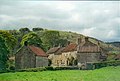
Cottages in the upper part of the village in Hawnby
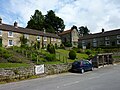
The lower part of Hawnby village in May 2003
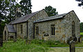
All Saints Church, Hawnby, Yorks.
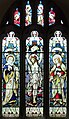
Stained Glass in All Saints Church, Hawnby

Arden Hall, Near Hawnby


References
^ ab UK Census (2011). "Local Area Report – Hawnby Parish (1170217250)". Nomis. Office for National Statistics. Retrieved 18 March 2018..mw-parser-output cite.citation{font-style:inherit}.mw-parser-output .citation q{quotes:"""""""'""'"}.mw-parser-output .citation .cs1-lock-free a{background:url("//upload.wikimedia.org/wikipedia/commons/thumb/6/65/Lock-green.svg/9px-Lock-green.svg.png")no-repeat;background-position:right .1em center}.mw-parser-output .citation .cs1-lock-limited a,.mw-parser-output .citation .cs1-lock-registration a{background:url("//upload.wikimedia.org/wikipedia/commons/thumb/d/d6/Lock-gray-alt-2.svg/9px-Lock-gray-alt-2.svg.png")no-repeat;background-position:right .1em center}.mw-parser-output .citation .cs1-lock-subscription a{background:url("//upload.wikimedia.org/wikipedia/commons/thumb/a/aa/Lock-red-alt-2.svg/9px-Lock-red-alt-2.svg.png")no-repeat;background-position:right .1em center}.mw-parser-output .cs1-subscription,.mw-parser-output .cs1-registration{color:#555}.mw-parser-output .cs1-subscription span,.mw-parser-output .cs1-registration span{border-bottom:1px dotted;cursor:help}.mw-parser-output .cs1-ws-icon a{background:url("//upload.wikimedia.org/wikipedia/commons/thumb/4/4c/Wikisource-logo.svg/12px-Wikisource-logo.svg.png")no-repeat;background-position:right .1em center}.mw-parser-output code.cs1-code{color:inherit;background:inherit;border:inherit;padding:inherit}.mw-parser-output .cs1-hidden-error{display:none;font-size:100%}.mw-parser-output .cs1-visible-error{font-size:100%}.mw-parser-output .cs1-maint{display:none;color:#33aa33;margin-left:0.3em}.mw-parser-output .cs1-subscription,.mw-parser-output .cs1-registration,.mw-parser-output .cs1-format{font-size:95%}.mw-parser-output .cs1-kern-left,.mw-parser-output .cs1-kern-wl-left{padding-left:0.2em}.mw-parser-output .cs1-kern-right,.mw-parser-output .cs1-kern-wl-right{padding-right:0.2em}
^ Hawnby in the Domesday Book. Retrieved 24 December 2012.
^ ab Ordnance Survey Open Viewer
^ "2001 UK Census". Retrieved 24 December 2012.
^ abc Bulmer's Topography, History and Directory (Private and Commercial) of North Yorkshire 1890. S&N Publishing. 1890. p. 707. ISBN 1-86150-299-0.
^ "All Saints". Retrieved 24 December 2012.
^ "Methodsist Chapel". Retrieved 24 December 2012.
^ "Listed Buildings". Retrieved 24 December 2012.
External links
| Wikimedia Commons has media related to Hawnby. |


