Glacier Point

The view from Glacier Point, left to right: Tenaya Canyon, Half Dome, Liberty Cap, Little Yosemite Valley, Vernal Fall and Nevada Fall.
Glacier Point is a viewpoint above Yosemite Valley, in California, United States. It is located on the south wall of Yosemite Valley at an elevation of 7,214 feet (2,199 m), 3,200 feet (980 m) above Half Dome Village. The point offers a superb view of several of Yosemite National Park's well-known landmarks including Yosemite Valley, Yosemite Falls, Half Dome, Vernal Fall, Nevada Fall, and Clouds Rest.
Contents
1 Geology
2 Access
3 Gallery
4 See also
5 References
6 External links
Geology
The extreme point of the promontory of Glacier Point is wholly bare, but on the slopes below, in the hollow to the west, and on the wooded slope above, glacial material is abundant. Its glacial origin is definitely proved by the presence in it of rocks derived from Little Yosemite Valley and the High Sierra
There are three types of glacially-deposited rock at Glacier Point:
- Most plentiful are rounded boulders and cobbles and angular fragments, all deeply weathered, of Half Dome quartz monzonite, the light-colored granite of which not only Half Dome, but all of the Little Yosemite and its surrounding heights are composed.[1]
- There are also a few boulders of a coarse-grained, highly siliceous granite, light buff in general tone when fresh but vivid rose when weathered. There is only one place in the High Sierra above the Yosemite from which they can be derived: Mount Clark, the sharp-profiled peak which stands on the east side of the Illilouette Basin, 8 miles (13 km) from Glacier Point.[1]
- Finally, there are fragments of yellowish quartzite and gray schist whose places of origin have been located on the long northern spur of Mount Clark.[1]
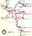
Access
Glacier Point can be reached from the Valley via Glacier Point Road.[2] During the summer, Glacier Point is often crowded with tourists. Tours by bus are also available and take about four hours.[3] The road is usually open from June through October. In winter, Glacier Point Road closes due to snow, and access to Glacier Point from the Badger Pass Ski Area is only by ski or snowshoe.[2]
Glacier Point can also be reached via the Four Mile Trail, which ascends the 3,200 feet (980 m) in 4.6 miles (7.4 km). This moderate to strenuous trail can provide access to Glacier Point when the Glacier Point Road is closed. Note, however, that the trail can be extremely hazardous when covered with snow or ice, so it is usually closed by the Park Service from December through May. Another 8.2 miles (13.2 km) trail runs from Glacier Point down to the Valley, via the Panorama Trail, past Nevada and Vernal Falls.
Hikers may also access trailheads to the Panorama trail and the Pohono trail.
Gallery

Glacier Point, as seen from Yosemite Valley. In springtime, this cliff face is covered with dozens of freshets and tiny waterfalls from the snowmelt, the largest being Staircase Falls.
View from Glacier Point
Location of Glacier Point within Yosemite


See also
- Glacier Point Hotel
- Four Mile Trail
- Yosemite Firefall
- Yosemite Valley
- Yosemite National Park
References
^ abc Matthes, F.E. (1930). "Evidences of an earlier ice invasion". Geologic History of the Yosemite Valley. United States Department of the Interior (USGS)..mw-parser-output cite.citation{font-style:inherit}.mw-parser-output .citation q{quotes:"""""""'""'"}.mw-parser-output .citation .cs1-lock-free a{background:url("//upload.wikimedia.org/wikipedia/commons/thumb/6/65/Lock-green.svg/9px-Lock-green.svg.png")no-repeat;background-position:right .1em center}.mw-parser-output .citation .cs1-lock-limited a,.mw-parser-output .citation .cs1-lock-registration a{background:url("//upload.wikimedia.org/wikipedia/commons/thumb/d/d6/Lock-gray-alt-2.svg/9px-Lock-gray-alt-2.svg.png")no-repeat;background-position:right .1em center}.mw-parser-output .citation .cs1-lock-subscription a{background:url("//upload.wikimedia.org/wikipedia/commons/thumb/a/aa/Lock-red-alt-2.svg/9px-Lock-red-alt-2.svg.png")no-repeat;background-position:right .1em center}.mw-parser-output .cs1-subscription,.mw-parser-output .cs1-registration{color:#555}.mw-parser-output .cs1-subscription span,.mw-parser-output .cs1-registration span{border-bottom:1px dotted;cursor:help}.mw-parser-output .cs1-ws-icon a{background:url("//upload.wikimedia.org/wikipedia/commons/thumb/4/4c/Wikisource-logo.svg/12px-Wikisource-logo.svg.png")no-repeat;background-position:right .1em center}.mw-parser-output code.cs1-code{color:inherit;background:inherit;border:inherit;padding:inherit}.mw-parser-output .cs1-hidden-error{display:none;font-size:100%}.mw-parser-output .cs1-visible-error{font-size:100%}.mw-parser-output .cs1-maint{display:none;color:#33aa33;margin-left:0.3em}.mw-parser-output .cs1-subscription,.mw-parser-output .cs1-registration,.mw-parser-output .cs1-format{font-size:95%}.mw-parser-output .cs1-kern-left,.mw-parser-output .cs1-kern-wl-left{padding-left:0.2em}.mw-parser-output .cs1-kern-right,.mw-parser-output .cs1-kern-wl-right{padding-right:0.2em}
^ ab "Yosemite Auto Touring". NPS. Retrieved 2008-05-16.
^ "Glacier Point Tours". DNC Parks & Resorts at Yosemite, Inc. Retrieved 2008-05-16.
External links
| Wikimedia Commons has media related to Glacier Point. |
Yosemite National Park: Glacier Point - U.S. National Park Service
 Yosemite National Park travel guide from Wikivoyage
- Photos from Glacier Point
- QTVR of Yosemite Valley, including good view of Glacier Point
Yosemite National Park | ||||||
|---|---|---|---|---|---|---|
| Attractions |
| |||||
| People |
| |||||
| Lodging & camping |
| |||||
| Natural disasters |
| |||||
| Transportation |
| |||||
| Nearby municipalities |
| |||||
| Additional information |
| |||||
| ||||||

Coordinates: 37°43′49″N 119°34′25″W / 37.7304°N 119.5736°W / 37.7304; -119.5736


