Carno
| Carno | |
|---|---|
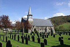 Church of St John the Baptist, Carno | |
 Carno Location within Powys | |
| Population | 730 (2011)[1] |
| OS grid reference | SN961965 |
| Principal area |
|
| Ceremonial county |
|
| Country | Wales |
| Sovereign state | United Kingdom |
| Post town | Caersws |
| Postcode district | SY17 |
| Dialling code | 01686 |
| Police | Dyfed-Powys |
| Fire | Mid and West Wales |
| Ambulance | Welsh |
| EU Parliament | Wales |
| UK Parliament |
|
Carno is a village in Powys, Wales. The community, which is also a parish in the historic county of Montgomeryshire, comprises the townships of Derlwyn, Llysyn, and Trowscoed. It is in the geographical centre of Wales.[2]
Contents
1 Geography
2 History
3 Transport
3.1 Rail
4 Notable people
5 References
6 External links
Geography
The Afon Carno rises near the watershed with the Afon Dyfi; and runs 9 miles south-eastward to the River Severn, 2¼ miles north of Llandinam. The village's name is supposedly derived from the Welsh language word for cairn (carnedd), as there are many ancient cairns on the hills surrounding the village. The A470 road between Llanbrynmair and Caersws passes through the village. This part of the route follows the course of the Afon Carno through hilly country.[3]
An electoral ward which includes the nearby village of Caersws had a population of 2316 in 2011.
History

Carno house, c.1885.
A Roman Fort named Gaer Noddfa is located next to the churchyard on the bank of the Afon Carno. The site encompasses a rectangular area 450 feet (140 m) by 270 feet (82 m).[4] A large mound occupies part of the fort; pottery found nearby indicate medieval usage but suggestions that it was a Norman fortification like a motte have been rejected.[5]
In 952, Iago and Ieuaf, the two exiled sons of Idwal Foel, King of Gwynedd, invaded Dyfed. But they were defeated in a decisive battle near Carno by the sons of Hywel Dda, King of Deheubarth. The victory secured the sovereignty of North Wales.[6] Another decisive battle took place here in 1081 in which "all the leading figures of the period took part, and which left its impress permanently on the history of Gwynedd and Deheubarth".[7]
A Grade II* 16th century timber-framed house, Plasau Duon, is near the village.[8]
The Manor House Plas Llysyn was a property raided as an LSD factory as part of Operation Julie. Plas Llysyn was under surveillance and the well that supplied the house was destroyed to investigate the contents. £500,000,000 of LSD was manufactured in the cellars here. Supplying 50% of the worlds LSD at the time.
Transport
Rail

The former railway station in 1986
The original Carno station was opened by the Newtown and Machynlleth Railway in 1863. It was closed, along with a number of stations on the Cambrian Line, as part of the Beeching cuts in the 1960s. In 2002 a campaign began to reopen a station near the village. In 2009 the Welsh Assembly agreed to examine the proposal as part of the Cambrian Rail Study.[9]
In 2014, the Welsh Assembly confirmed Arriva Trains Wales and Network Rail broadly agreed with an independent report recommending the reopening of a station at Carno.[10] However, a new station would need to be built as the original Victorian building (which was incorporated into the former Laura Ashley factory) is in private ownership.[11]
Notable people
- The designer and entrepreneur Laura Ashley (1925–1985) is buried in the churchyard.[12] Bernard and Laura Ashley moved from Kent to Carno in 1961. The company's original factory was in the village; it closed in 2005.[11]
- The parents of Chicago Outfit gangster Morris Llewellyn Humphreys emigrated to the United States from the village in the late 19th century.[13]
References
^ "Community population 2011". Retrieved 10 November 2015..mw-parser-output cite.citation{font-style:inherit}.mw-parser-output .citation q{quotes:"""""""'""'"}.mw-parser-output .citation .cs1-lock-free a{background:url("//upload.wikimedia.org/wikipedia/commons/thumb/6/65/Lock-green.svg/9px-Lock-green.svg.png")no-repeat;background-position:right .1em center}.mw-parser-output .citation .cs1-lock-limited a,.mw-parser-output .citation .cs1-lock-registration a{background:url("//upload.wikimedia.org/wikipedia/commons/thumb/d/d6/Lock-gray-alt-2.svg/9px-Lock-gray-alt-2.svg.png")no-repeat;background-position:right .1em center}.mw-parser-output .citation .cs1-lock-subscription a{background:url("//upload.wikimedia.org/wikipedia/commons/thumb/a/aa/Lock-red-alt-2.svg/9px-Lock-red-alt-2.svg.png")no-repeat;background-position:right .1em center}.mw-parser-output .cs1-subscription,.mw-parser-output .cs1-registration{color:#555}.mw-parser-output .cs1-subscription span,.mw-parser-output .cs1-registration span{border-bottom:1px dotted;cursor:help}.mw-parser-output .cs1-ws-icon a{background:url("//upload.wikimedia.org/wikipedia/commons/thumb/4/4c/Wikisource-logo.svg/12px-Wikisource-logo.svg.png")no-repeat;background-position:right .1em center}.mw-parser-output code.cs1-code{color:inherit;background:inherit;border:inherit;padding:inherit}.mw-parser-output .cs1-hidden-error{display:none;font-size:100%}.mw-parser-output .cs1-visible-error{font-size:100%}.mw-parser-output .cs1-maint{display:none;color:#33aa33;margin-left:0.3em}.mw-parser-output .cs1-subscription,.mw-parser-output .cs1-registration,.mw-parser-output .cs1-format{font-size:95%}.mw-parser-output .cs1-kern-left,.mw-parser-output .cs1-kern-wl-left{padding-left:0.2em}.mw-parser-output .cs1-kern-right,.mw-parser-output .cs1-kern-wl-right{padding-right:0.2em}
^ "The town at the centre of Britain". BBC NEWS. 22 August 2014.
^ "Ordnance Survey map 128: Montgomery". One inch series. Ordnance Survey. Missing or empty|url=(help)
^ Wilson, D. R.; Wright, R. P. (1965). "Roman Britain (1964)". The Journal of Roman Studies. www.jstor.org. 55 (1/2): 199–228. doi:10.2307/297440. JSTOR 297440.]
^ "Gaer Noddfa, Carno". www.gatehouse-gazetteer.info. Retrieved 6 January 2016.
^ Charles-Edwards, T.M. (2013). Wales and the Britons, 350-1064. OUP Oxford. p. 537. ISBN 978-0-19-821731-2.
^ Wolcott, Darrell. "The battle of Mynydd Carn". Ancient Wales Studies. Retrieved 28 April 2016.
^ "Plasau Duon, Caersws". British Listed Buildings. Retrieved 28 April 2016.
^ "Campaign to reopen station gets a boost". Shropshire Star. August 13, 2009. Archived from the original on 2009-08-21. Retrieved 17 Nov 2009.
^ "Support to re-open Carno railway station". BBC NEWS. 6 January 2016.
^ ab "Laura Ashley shuts 'home' factory". BBC. October 25, 2004. Retrieved February 2008. Check date values in:|accessdate=(help)
^ Laura Ashley burial place
^ Brookes, Geoff (2014). Welsh History: Strange but True. History Press. p. 187. ISBN 978-0-7509-5498-3.
External links
- Photos of Carno and surrounding area on geograph.org.uk
- http://carnostation.org.uk/
Powys | ||
|---|---|---|
| Principal settlements |
|  |
| Communities |
| |
| Towns and villages |
| |
| Castles |
| |
| Reservoirs and lakes |
| |
| Topics |
| |


