Tholen
Tholen | |
|---|---|
Municipality | |
 Harbour of Tholen | |
 Flag  Coat of arms | |
 Location in Zeeland | |
| Coordinates: 51°32′N 4°12′E / 51.533°N 4.200°E / 51.533; 4.200Coordinates: 51°32′N 4°12′E / 51.533°N 4.200°E / 51.533; 4.200 | |
| Country | Netherlands |
| Province | Zeeland |
| Government [1] | |
| • Body | Municipal council |
| • Mayor | Ger van de Velde-de Wilde (VVD) |
| Area [2] | |
| • Total | 254.00 km2 (98.07 sq mi) |
| • Land | 147.09 km2 (56.79 sq mi) |
| • Water | 106.91 km2 (41.28 sq mi) |
| Elevation [3] | -1 m (−3 ft) |
| Population (August 2017)[4] | |
| • Total | 25,547 |
| • Density | 174/km2 (450/sq mi) |
| Demonym(s) | Tholenaar |
| Time zone | UTC+1 (CET) |
| • Summer (DST) | UTC+2 (CEST) |
| Postcode | 4675, 4690–4699 |
| Area code | 0166, 0167 |
| Website | www.tholen.nl |
Tholen (![]() pronunciation (help·info)) is a 25,000 people municipality in the southwest of the Netherlands. The municipality of Tholen takes its name from the town of Tholen, which is the largest population center in the municipality.
pronunciation (help·info)) is a 25,000 people municipality in the southwest of the Netherlands. The municipality of Tholen takes its name from the town of Tholen, which is the largest population center in the municipality.
The municipality consists of two peninsulas, formerly islands, the larger one on the south also called Tholen, the smaller one on the north called Sint Philipsland. The two are separated by the former strait, now bay, of Krabbenkreek. The municipality is bordered on the east by the Eendracht, once a Scheldt branch but now part of the Scheldt-Rhine Canal, crossed by three road bridges, by the Oosterschelde estuary to the south, the straits of Keeten-Mastgat to the west and the Krammer strait to the north.
The town has a small historical center partly surrounded by a "gracht" and partly bordered by a harbour for fishing boats and yachts.
Contents
1 Population centers
2 Twin towns
3 Images
4 References
5 External links
Population centers

Dutch Topographic map of Tholen, June 2015
On the island Sint Philipsland there are three villages:
- Sint Philipsland
- Anna Jacobapolder
- Sluis
On the island Tholen there are seven population centers:
- Oud-Vossemeer
- Poortvliet
- Scherpenisse
- Sint-Annaland
- Sint-Maartensdijk
- Stavenisse
- Tholen
Twin towns
 Iława, Poland
Images
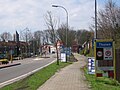
Entrance at the north of the town

Former city hall

Mill "de Hoop"

Great Church

Venkelstreet
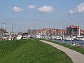
Harbour
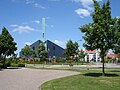
Reformed Congregation Tholen


References
^ "College van B&W" [Board of mayor and aldermen] (in Dutch). Gemeente Tholen. Retrieved 17 December 2013..mw-parser-output cite.citation{font-style:inherit}.mw-parser-output .citation q{quotes:"""""""'""'"}.mw-parser-output .citation .cs1-lock-free a{background:url("//upload.wikimedia.org/wikipedia/commons/thumb/6/65/Lock-green.svg/9px-Lock-green.svg.png")no-repeat;background-position:right .1em center}.mw-parser-output .citation .cs1-lock-limited a,.mw-parser-output .citation .cs1-lock-registration a{background:url("//upload.wikimedia.org/wikipedia/commons/thumb/d/d6/Lock-gray-alt-2.svg/9px-Lock-gray-alt-2.svg.png")no-repeat;background-position:right .1em center}.mw-parser-output .citation .cs1-lock-subscription a{background:url("//upload.wikimedia.org/wikipedia/commons/thumb/a/aa/Lock-red-alt-2.svg/9px-Lock-red-alt-2.svg.png")no-repeat;background-position:right .1em center}.mw-parser-output .cs1-subscription,.mw-parser-output .cs1-registration{color:#555}.mw-parser-output .cs1-subscription span,.mw-parser-output .cs1-registration span{border-bottom:1px dotted;cursor:help}.mw-parser-output .cs1-ws-icon a{background:url("//upload.wikimedia.org/wikipedia/commons/thumb/4/4c/Wikisource-logo.svg/12px-Wikisource-logo.svg.png")no-repeat;background-position:right .1em center}.mw-parser-output code.cs1-code{color:inherit;background:inherit;border:inherit;padding:inherit}.mw-parser-output .cs1-hidden-error{display:none;font-size:100%}.mw-parser-output .cs1-visible-error{font-size:100%}.mw-parser-output .cs1-maint{display:none;color:#33aa33;margin-left:0.3em}.mw-parser-output .cs1-subscription,.mw-parser-output .cs1-registration,.mw-parser-output .cs1-format{font-size:95%}.mw-parser-output .cs1-kern-left,.mw-parser-output .cs1-kern-wl-left{padding-left:0.2em}.mw-parser-output .cs1-kern-right,.mw-parser-output .cs1-kern-wl-right{padding-right:0.2em}
^ "Kerncijfers wijken en buurten" [Key figures for neighbourhoods]. CBS Statline (in Dutch). CBS. 2 July 2013. Retrieved 12 March 2014.
^ "Postcodetool for 4691DZ". Actueel Hoogtebestand Nederland (in Dutch). Het Waterschapshuis. Retrieved 17 December 2013.
^ "Bevolkingsontwikkeling; regio per maand" [Population growth; regions per month]. CBS Statline (in Dutch). CBS. 27 October 2017. Retrieved 27 October 2017.
External links
| Wikivoyage has a travel guide for Tholen. |
 Media related to Tholen at Wikimedia Commons
- Official website
Places adjacent to Tholen | ||||||||||
|---|---|---|---|---|---|---|---|---|---|---|
| ||||||||||
Municipalities of Zeeland | ||
|---|---|---|
|  | |
| ||
This article about a location in Zeeland is a stub. You can help Wikipedia by expanding it. |


