Moygoish
Moygoish Uí Mhac gCuais | |
|---|---|
Barony | |
 Location of Moygoish on a map of Westmeath | |
 Moygoish Location in Ireland | |
| Coordinates: 53°37′54″N 7°29′44″W / 53.6317°N 7.4956°W / 53.6317; -7.4956Coordinates: 53°37′54″N 7°29′44″W / 53.6317°N 7.4956°W / 53.6317; -7.4956 | |
| Country | Ireland |
| Province | Leinster |
| County | Westmeath |
| Area | |
| • Total | 163.2 km2 (63.0 sq mi) |
| Time zone | UTC+0 (WET) |
| • Summer (DST) | UTC+1 (IST (WEST)) |
| Irish Grid Reference | N334647 |
Moygoish (Irish: Uí Mhac gCuais)[1] is a barony in north County Westmeath, in the Republic of Ireland, formed by 1672.[2] It is bordered by County Longford to the west and four other Westmeath baronies: Corkaree (to the east), Fore (to the north–east), Moyashel and Magheradernon (to the south–east) and Rathconrath to the south–west.
Contents
1 Geography
2 Civil parishes of the barony
3 Towns, villages and townlands
4 Places of interest
5 References
6 External links
Geography
Moygoish has an area of 40,320.4 acres (163.171 km2).[2]
The barony contains the western end of the large lake, Lough Derravaragh, and also the small lake of Lough Iron. Lough Derravaragh is shared with the baronies of Corkaree and Fore and is home to the Irish legend of the Children of Lir. Lough Iron is a small lake on the River Inny and is shared with the barony of Corkaree. The lake is not easily accessible as there is no road close to the lake or public access. The River Inny flows through Lough Iron, then near the small village of Rathowen, before it connects to the River Shannon.
The N4, a national primary road passes through the village of Rathowen, connecting Dublin with the northwest of Ireland and the coastal town of Sligo. A railway line carrying the national rail company Iarnród Éireann's Dublin to Longford commuter service and Dublin to Sligo intercity service.[3] also passes through the barony.
The Royal Canal passes through the village of Ballynacargy connecting the River Liffey in Dublin to Longford town.
Civil parishes of the barony
This table[4] lists an historical geographical sub-division of the barony known as the civil parish (not to be confused with an Ecclesiastical parish).
| Name in English | Name in Irish |
|---|---|
Kilbixy | Cill Bhiscí |
Kilmacnevan | Cill Mhic Naomháin |
Rathaspick | Ráth Easpaig |
Russagh | An Rosach |
Street | An tSráid |
Templeoran | Teampall Odhráin |
Towns, villages and townlands
Ballynacargy, or Ballinacarrigy, a small village on the R393 regional road.
Rathowen (Irish: Ráth Eoghain, meaning "Eoghan's Ringfort"), a small village on the N4 national primary route.
Street, a village on the L1927 local road.
There are 115 townlands in the barony of Moygoish.[2]
Places of interest
Tristernagh Abbey, also known as the Priory of Kilbixy, is a ruined Augustinian priory founded in 1192, situated on the shores of Lough Iron.
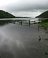
Lough Derravaragh

Royal Canal south–east of Ballynacargy


References
^ Barony of Moygoish The Placenames Database of Ireland. Retrieved 23 May 2015
^ abc Moygoishtownlands.ie Retrieved 23 May 2015
^ Irish Rail Printable Timetables irishrail.ie Retrieved 23 May 2015
^ Civil parishes of the barony of Moygoish. The Placenames Database of Ireland. Retrieved 7 June 2015
External links
Map of Moygoish at openstreetmap.org
Barony of Moygoish, County Westmeath at townlands.ie
Places in County Westmeath | ||
|---|---|---|
County town: Mullingar | ||
| Towns |
|  |
| Villages |
| |
| Baronies |
| |
| ||


