Singleton, Lancashire
| Singleton | |
|---|---|
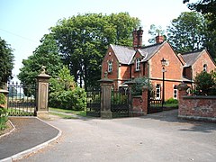 Singleton Park Gatehouse | |
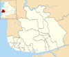
 Singleton Shown within Fylde Borough Show map of the Borough of Fylde  Singleton Shown within the Fylde Show map of the Fylde  Singleton Location within Lancashire Show map of Lancashire | |
| Population | 889 (2011 Census) |
| OS grid reference | SD380382 |
| Civil parish |
|
| District |
|
| Shire county |
|
| Region |
|
| Country | England |
| Sovereign state | United Kingdom |
| Post town | POULTON-LE-FYLDE |
| Postcode district | FY6 |
| Dialling code | 01253 |
| Police | Lancashire |
| Fire | Lancashire |
| Ambulance | North West |
| EU Parliament | North West England |
| UK Parliament |
|
Singleton is a village and civil parish in Lancashire, England. It is situated on the coastal plain called the Fylde. It is located south-east of Poulton-le-Fylde, and at the 2001 census had a population of 877,[1] increasing to 889 at the 2011 Census.[2] The parish is sometimes referred to as two parts – Great Singleton is the larger part containing the village, and Little Singleton is a small area north of the village bordering the River Wyre.[3]
Contents
1 History
2 Fracking
3 Governance
4 See also
5 References
5.1 Footnotes
5.2 Sources
6 External links
History
At the time of the Roman conquest of Britain in the 1st century AD, the area around Singleton was inhabited by a Celtic tribe called the Setantii.[4] The village was recorded in the Domesday Book of 1086 as Singletun.[3]
Singleton railway station once served the village as part of the Preston and Wyre Joint Railway. The station was situated west of the village, on the road to Blackpool.
Singleton Hall is a Gothic mansion on Lodge Lane, built in 1873 for Thomas Horrocks Miller, son of a prominent Preston industrialist. The Hall was later used by Lancashire County Council as a special school and is now converted into private residences. The grounds are open to the public and maintained by the Richard Dumbreck Singleton Trust, endowed by Richard Dumbreck, a great-nephew of Thomas Horrocks Miller. [5]
The Miller family also commissioned Singleton's parish church, St Anne's, designed by Lancaster architect Edward Graham Paley and completed in 1861.[6] It has been designated a Grade II listed building by English Heritage.[7]
Fracking
In 2011, drilling equipment was installed at Grange Hill, east of the village, to test for shale gas in the Bowland Shale Formation around 3 km below the surface.[8] In 2013 Cuadrilla and Centrica made plans for hydraulic fracturing, commonly known as fracking, at the site.[9]
Governance
Singleton is combined with Greenhalgh-with-Thistleton to form the ward of Singleton and Greenhalgh, which elects one councillor.[10] As of 2008[update] it is represented by Maxine Chew, an independent councillor.[11] Singleton also has a parish council.
The village is represented in the House of Commons of the Parliament of the United Kingdom as part of Fylde. It elects one Member of Parliament (MP) by the first past the post system of election. Since the 2010 general election, Fylde has been represented at Parliament by Conservative MP Mark Menzies. The village is also part of the North West England constituency of the European Parliament.

The Miller Arms pub in Singleton.
See also
- Listed buildings in Singleton, Lancashire
References
Footnotes
^ Office for National Statistics : Census 2001 : Parish Headcounts : Fylde Retrieved 9 February 2010
^ "Civil Parish population 2011". Retrieved 23 January 2016..mw-parser-output cite.citation{font-style:inherit}.mw-parser-output .citation q{quotes:"""""""'""'"}.mw-parser-output .citation .cs1-lock-free a{background:url("//upload.wikimedia.org/wikipedia/commons/thumb/6/65/Lock-green.svg/9px-Lock-green.svg.png")no-repeat;background-position:right .1em center}.mw-parser-output .citation .cs1-lock-limited a,.mw-parser-output .citation .cs1-lock-registration a{background:url("//upload.wikimedia.org/wikipedia/commons/thumb/d/d6/Lock-gray-alt-2.svg/9px-Lock-gray-alt-2.svg.png")no-repeat;background-position:right .1em center}.mw-parser-output .citation .cs1-lock-subscription a{background:url("//upload.wikimedia.org/wikipedia/commons/thumb/a/aa/Lock-red-alt-2.svg/9px-Lock-red-alt-2.svg.png")no-repeat;background-position:right .1em center}.mw-parser-output .cs1-subscription,.mw-parser-output .cs1-registration{color:#555}.mw-parser-output .cs1-subscription span,.mw-parser-output .cs1-registration span{border-bottom:1px dotted;cursor:help}.mw-parser-output .cs1-ws-icon a{background:url("//upload.wikimedia.org/wikipedia/commons/thumb/4/4c/Wikisource-logo.svg/12px-Wikisource-logo.svg.png")no-repeat;background-position:right .1em center}.mw-parser-output code.cs1-code{color:inherit;background:inherit;border:inherit;padding:inherit}.mw-parser-output .cs1-hidden-error{display:none;font-size:100%}.mw-parser-output .cs1-visible-error{font-size:100%}.mw-parser-output .cs1-maint{display:none;color:#33aa33;margin-left:0.3em}.mw-parser-output .cs1-subscription,.mw-parser-output .cs1-registration,.mw-parser-output .cs1-format{font-size:95%}.mw-parser-output .cs1-kern-left,.mw-parser-output .cs1-kern-wl-left{padding-left:0.2em}.mw-parser-output .cs1-kern-right,.mw-parser-output .cs1-kern-wl-right{padding-right:0.2em}
^ ab Farrer & Brownbill (1912), pp. 183–188
^ Storey (2001), p. 9
^ "History of Singleton". The Richard Dumbreck Singleton Trust.
^ Hartwell & Pevsner (2009), p. 613
^ "Church Of St Anne, Church Road", Heritage Gateway, English heritage, retrieved 30 October 2010
^ Harvey, Fiona (24 September 2011). "Energy firm Cuadrilla discovers huge gas reserves under Lancashire". The Guardian. Retrieved 8 November 2013.
^ Gosden, Emily (5 July 2013). "Cuadrilla and Centrica unveil two-year fracking programme". The Telegraph. Retrieved 8 November 2013.
^ http://www.opsi.gov.uk/SI/si2001/uksi_20012475_en.pdf
^ "Singleton and Greenhalgh". Fylde Borough Council. Archived from the original on 9 March 2007. Retrieved 2008-12-31.
Sources
.mw-parser-output .refbegin{font-size:90%;margin-bottom:0.5em}.mw-parser-output .refbegin-hanging-indents>ul{list-style-type:none;margin-left:0}.mw-parser-output .refbegin-hanging-indents>ul>li,.mw-parser-output .refbegin-hanging-indents>dl>dd{margin-left:0;padding-left:3.2em;text-indent:-3.2em;list-style:none}.mw-parser-output .refbegin-100{font-size:100%}
Farrer, William; Brownbill, J., eds. (1912), "Townships — Singleton", A History of the County of Lancaster: Volume 7, Constable, OCLC 59626695
Hartwell, Clare; Pevsner, Nikolaus (2009) [1969], Lancashire: North, New Haven and London: Yale University Press, ISBN 0-300-12667-0
Storey, Christine (2001), Poulton-le-Fylde, Stroud: Tempus Publishing, ISBN 0-7524-2442-4
External links
 Media related to Singleton, Lancashire at Wikimedia Commons
Geography of the Borough of Fylde | ||
|---|---|---|
| Towns |
|  |
| Villages |
| |
| Parishes |
| |
| Topography |
| |


