San Costantino Calabro
San Costantino Calabro | |
|---|---|
Comune | |
| Comune di San Costantino Calabro | |
Location of San Costantino Calabro | |
 San Costantino Calabro Location of San Costantino Calabro in Italy Show map of Italy  San Costantino Calabro San Costantino Calabro (Calabria) Show map of Calabria | |
| Coordinates: 38°38′N 16°4′E / 38.633°N 16.067°E / 38.633; 16.067Coordinates: 38°38′N 16°4′E / 38.633°N 16.067°E / 38.633; 16.067 | |
| Country | Italy |
| Region | Calabria |
| Province | Province of Vibo Valentia (VV) |
| Frazioni | non ha frazioni |
| Area | |
| • Total | 7.0 km2 (2.7 sq mi) |
| Elevation | 454 m (1,490 ft) |
| Population (Dec. 2004) | |
| • Total | 2,320 |
| • Density | 330/km2 (860/sq mi) |
| Demonym(s) | Sancostantinesi |
| Time zone | UTC+1 (CET) |
| • Summer (DST) | UTC+2 (CEST) |
| Postal code | 89851 |
| Dialing code | 0963 |
| Website | Official website |
San Costantino Calabro (Greek: Aghios Konstantinos Kalavros) is a comune (municipality) in the Province of Vibo Valentia in the Italian region Calabria, located about 50 kilometres (31 mi) southwest of Catanzaro and about 4 kilometres (2 mi) southwest of Vibo Valentia. As of 31 December 2004, it had a population of 2,320 and an area of 7.0 square kilometres (2.7 sq mi).[1]
San Costantino Calabro borders the following municipalities: Francica, Jonadi, Mileto, San Gregorio d'Ippona.
Contents
1 Demographic evolution
2 Pictures
3 References
4 External links
Demographic evolution

Pictures

Sign in the center of the comune of San Costantino
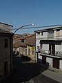
Center of the comune of San Costantino

One of the many lemon trees
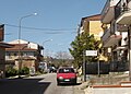
Road in San Costantino


References
^ All demographics and other statistics: Italian statistical institute Istat.
External links
This Calabrian location article is a stub. You can help Wikipedia by expanding it. |