Verran
Verran kommune | |||
|---|---|---|---|
Municipality | |||
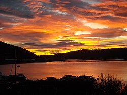 View from Malm at sunset | |||
| |||
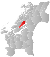 Verran within Trøndelag | |||
| Coordinates: 64°01′27″N 10°58′44″E / 64.02417°N 10.97889°E / 64.02417; 10.97889Coordinates: 64°01′27″N 10°58′44″E / 64.02417°N 10.97889°E / 64.02417; 10.97889 | |||
| Country | Norway | ||
| County | Trøndelag | ||
| District | Innherad | ||
| Established | 1 Jan 1901 | ||
| Administrative centre | Malm | ||
| Government | |||
| • Mayor (2015) | Anders Lindstrøm (Ap) | ||
| Area | |||
| • Total | 601.66 km2 (232.30 sq mi) | ||
| • Land | 558.15 km2 (215.50 sq mi) | ||
| • Water | 43.51 km2 (16.80 sq mi) 7.2% | ||
| Area rank | #185 in Norway | ||
| Population (2017) | |||
| • Total | 2,515 | ||
| • Rank | #294 in Norway | ||
| • Density | 4.5/km2 (12/sq mi) | ||
| • Change (10 years) | -4.1% | ||
| Demonym(s) | Verrabygg[1] | ||
| Time zone | UTC+01:00 (CET) | ||
| • Summer (DST) | UTC+02:00 (CEST) | ||
| ISO 3166 code | NO-5039 | ||
| Official language form | Neutral | ||
| Website | verran.kommune.no | ||
Data from Statistics Norway | |||

Verran is a municipality in Trøndelag county, Norway. It is part of the Innherred region. The administrative centre of the municipality is the village of Malm. Other villages in Verran include Follafoss, Sela, Verrabotn, and Verrastranda.
The 602-square-kilometre (232 sq mi) municipality is the 185th largest by area out of the 422 municipalities in Norway. Verran is the 294th most populous municipality in Norway with a population of 2,515. The municipality's population density is 4.5 inhabitants per square kilometre (12/sq mi) and its population has decreased by 4.1% over the last decade.[2]
Contents
1 General information
1.1 Name
1.2 Coat of arms
1.3 Churches
2 Geography
3 Government
3.1 Municipal council
4 Economy
5 References
6 External links
General information
The municipality of Verran was established on 1 January 1901 when the old municipality of Mosvik og Verran was divided into two new municipalities: Mosvik (population: 969) and Verran (population: 1,456). During the 1960s, there were many municipal mergers across Norway due to the work of the Schei Committee. On 1 January 1964, the neighboring municipalities of Malm (population: 2,975) to the north and Verran (population: 1,803) to the south were merged to form a new municipality of Verran. After the merger, there were 4,778 residents in Verran. On 1 January 1968, the Framverran area on the south side of the Verrasundet fjord (population: 395) was transferred from Verran to the neighboring municipality of Mosvik.[3]
On 1 January 2018, the municipality switched from the old Nord-Trøndelag county to the new Trøndelag county.
On 1 January 2020 the municipality of Verran will merge with the neighboring municipality of Steinkjer to form a new, larger municipality of Steinkjer.[4]
Name
The municipality is named after the Verrasundet fjord (Old Norse: Veri), which is an arm of the great Trondheimsfjord. The meaning of the old name is probably "the quiet one" or "the fjord with still water".[5]
Coat of arms
The coat of arms is from modern times; they were granted on 11 September 1987. The arms show a blue background with a silver verranjekt, a type of boat that is common in the area.[6][7]
Churches
The Church of Norway has two parishes (sokn) within the municipality of Verran. It is part of the Nord-Innherad prosti (deanery) in the Diocese of Nidaros.
| Parish (Sokn) | Church Name | Location of the Church | Year Built |
|---|---|---|---|
| Malm | Malm Church | Malm | 1885 |
| Sela Church | Sela | 1997 | |
| Verran | Fines Church | Verrabotn | 1913 |
| Follafoss Church | Follafoss | 1954 |
Geography
Verran borders the municipalities of Åfjord to the west, Indre Fosen to the south, Inderøy to the southeast, Steinkjer to the east, and Namdalseid to the north. Verran encompasses the western coastline of the Beitstadfjord, an arm of the Trondheimsfjord. There are three large lakes in Verran: Ormsetvatnet, Selavatnet, and Holden. The river Follaelva runs through the municipality, emptying into the Trondheimsfjord at Follafoss.
Government
All municipalities in Norway, including Verran, are responsible for primary education (through 10th grade), outpatient health services, senior citizen services, unemployment and other social services, zoning, economic development, and municipal roads. The municipality is governed by a municipal council of elected representatives, which in turn elect a mayor. The municipality falls under the Inntrøndelag District Court and the Frostating Court of Appeal.
Municipal council
The municipal council (Kommunestyre) of Verran is made up of 19 representatives that are elected to four year terms. Currently, the party breakdown is as follows:[8]
| Party Name | Name in Norwegian | Number of representatives | |
|---|---|---|---|
| Labour Party | Arbeiderpartiet | 7 | |
| Progress Party | Fremskrittspartiet | 1 | |
| Conservative Party | Høyre | 1 | |
| Centre Party | Senterpartiet | 7 | |
| Liberal Party | Venstre | 3 | |
| Total number of members: | 19 | ||
Economy
Forestry is an important industry in Verran. There is also a paper mill in Follafoss that is a large factory. The paper mill is owned by Södra Cell Folla.
References
^ "Navn på steder og personer: Innbyggjarnamn" (in Norwegian). Språkrådet. Retrieved 2015-12-01..mw-parser-output cite.citation{font-style:inherit}.mw-parser-output .citation q{quotes:"""""""'""'"}.mw-parser-output .citation .cs1-lock-free a{background:url("//upload.wikimedia.org/wikipedia/commons/thumb/6/65/Lock-green.svg/9px-Lock-green.svg.png")no-repeat;background-position:right .1em center}.mw-parser-output .citation .cs1-lock-limited a,.mw-parser-output .citation .cs1-lock-registration a{background:url("//upload.wikimedia.org/wikipedia/commons/thumb/d/d6/Lock-gray-alt-2.svg/9px-Lock-gray-alt-2.svg.png")no-repeat;background-position:right .1em center}.mw-parser-output .citation .cs1-lock-subscription a{background:url("//upload.wikimedia.org/wikipedia/commons/thumb/a/aa/Lock-red-alt-2.svg/9px-Lock-red-alt-2.svg.png")no-repeat;background-position:right .1em center}.mw-parser-output .cs1-subscription,.mw-parser-output .cs1-registration{color:#555}.mw-parser-output .cs1-subscription span,.mw-parser-output .cs1-registration span{border-bottom:1px dotted;cursor:help}.mw-parser-output .cs1-ws-icon a{background:url("//upload.wikimedia.org/wikipedia/commons/thumb/4/4c/Wikisource-logo.svg/12px-Wikisource-logo.svg.png")no-repeat;background-position:right .1em center}.mw-parser-output code.cs1-code{color:inherit;background:inherit;border:inherit;padding:inherit}.mw-parser-output .cs1-hidden-error{display:none;font-size:100%}.mw-parser-output .cs1-visible-error{font-size:100%}.mw-parser-output .cs1-maint{display:none;color:#33aa33;margin-left:0.3em}.mw-parser-output .cs1-subscription,.mw-parser-output .cs1-registration,.mw-parser-output .cs1-format{font-size:95%}.mw-parser-output .cs1-kern-left,.mw-parser-output .cs1-kern-wl-left{padding-left:0.2em}.mw-parser-output .cs1-kern-right,.mw-parser-output .cs1-kern-wl-right{padding-right:0.2em}
^ Statistisk sentralbyrå (2017). "Table: 06913: Population 1 January and population changes during the calendar year (M)" (in Norwegian). Retrieved 2017-10-02.
^ Jukvam, Dag (1999). "Historisk oversikt over endringer i kommune- og fylkesinndelingen" (PDF) (in Norwegian). Statistisk sentralbyrå.
^ "Bakgrunn" (in Norwegian). NyeSteinkjer.no. Retrieved 2017-10-02.
^ Rygh, Oluf (1903). Norske gaardnavne: Nordre Trondhjems amt (dokpro.uio.no) (in Norwegian) (15 ed.). Kristiania, Norge: W. C. Fabritius & sønners bogtrikkeri. p. 168.
^ "Nord-Trøndelag fylke" (in Norwegian). Retrieved 2008-11-17.
^ "Civic heraldry of Norway - Norske Kommunevåpen". Heraldry of the World. Retrieved 2018-04-15.
^ "Table: 04813: Members of the local councils, by party/electoral list at the Municipal Council election (M)" (in Norwegian). Statistics Norway. 2015.
External links
| Wikimedia Commons has media related to Verran. |
 Trøndelag travel guide from Wikivoyage
Municipal fact sheet from Statistics Norway (in Norwegian)
Trøndelag county, Norway | |||||||||
|---|---|---|---|---|---|---|---|---|---|
| |||||||||
| |||||||||
| |||||||||
| |||||||||


