Trondheim Fjord
| Trondheimsfjorden | |
|---|---|
| Trondheim Fjord | |
 Map of Trondheim Fjord and the Fosen peninsula | |
 Trondheimsfjorden Location of the fjord Show map of Trøndelag  Trondheimsfjorden Trondheimsfjorden (Norway) Show map of Norway | |
| Location | Trøndelag county, Norway |
| Coordinates | 63°49′09″N 11°06′28″E / 63.8192°N 11.1078°E / 63.8192; 11.1078Coordinates: 63°49′09″N 11°06′28″E / 63.8192°N 11.1078°E / 63.8192; 11.1078 |
| Type | Fjord |
Basin countries | Norway |
| Max. length | 130 kilometres (81 mi) |
| Max. depth | 617 metres (2,024 ft) |
| Settlements | Trondheim, Stjørdalshalsen, Levanger, Steinkjer |
The Trondheim Fjord[1][2][3] or Trondheimsfjorden (pronounced [²trɔnːhæɪmsˌfjuːɳ̍]), an inlet of the Norwegian Sea, is Norway's third-longest fjord at 130 kilometres (81 mi) long. It is located in the west-central part of the country in Trøndelag county, and it stretches from the municipality of Ørland in the west to the municipality of Steinkjer in the north, passing the city of Trondheim on its way. Its maximum depth is 617 metres (2,024 ft), between Agdenes and Indre Fosen.
The largest islands in the fjord are Ytterøya and Tautra; the small island of Munkholmen is located near the harbor of Trondheim; and there are several islands at the entrance of the fjord. The narrow Skarnsundet is crossed by the Skarnsund Bridge. The part of the fjord to the north of the strait is referred to as the Beitstadfjorden. The main part of the Trondheimsfjord is ice-free all year; only Verrasundet, a long and narrow fjord branch in the northern part of the fjord, might be ice covered in winter. The Beitstadfjorden might also freeze over in winter, but only for a few weeks.
The towns of Stjørdalshalsen, Levanger, and Steinkjer are found on the eastern and northeastern shores of the fjord. Aker Verdal in Verdal produces large offshore installations for the petroleum sector. A yard in Indre Fosen completed the luxurious apartment ship MS The World. Fiborgtangen is a peninsula along the eastern shore of the fjord where a large paper mill owned by Norske Skog is located.
The Trondheimsfjord has rich marine life, with both southern and northern species; at least 90 species of fish have been observed, and the fjord has the largest biological production among Norway's fjords.[4] In recent years, deep water corals (Lophelia pertusa) were discovered in the fjord, not far from the city of Trondheim. Several of the best salmon rivers in Norway empty into the fjord. Among these are the rivers Gaula (in Melhus just south of Trondheim), Orklaelva (in Orkdal), Stjørdalselva (in Stjørdal), and Verdalselva (in Verdal).
The lowland east and south of the fjord represents one of Norway's best agricultural areas. The more rugged and mountainous Fosen peninsula lies to the west and northwest, giving some shelter from the wind common to coastal areas.
The Trondheimsfjord was an important waterway in the Viking Age, as it is still today. In 1888, an undersea mudslide caused a tsunami that killed one person in Trondheim and ruptured three railway lines.
Four giant squid have been found in the fjord, which is among the highest concentrations in the world.[5]
Contents
1 Name
2 Media gallery
3 See also
4 References
5 External links
Name
The fjord is named after the city of Trondheim, but originally the name of the fjord might have been just *Þrónd or *Þróund in Old Norse. A name like that would be related to the verb þróast, which means to 'thrive' or 'flourish' and the name Þrór, which means 'likeable' or 'stoutish' (and was one of Odin's nicknames).
If this is the case, then the people living around the fjord (the þrœndir; see Trøndelag) named themselves after the fjord. (Compare sygnir, which means 'the people living around the fjord Sogn'.)
Media gallery
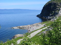
Korsvika, eastern Trondheim, view towards north.
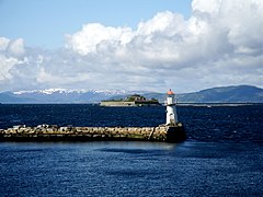
Lighthouse and the island Munkholmen

Åsenfjord, near Stjørdal. The Tirpitz was moored nearby during parts of WWII.

Coastal farm area along the fjord.
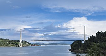
Skarnsund Bridge, the only road crossing on the fjord.

Harbour of Trondheim


See also
- Ellen Lie
- Petter Lie
References
^ Chippindale, Christopher; Taçon, Paul S. C. (1998). The Archaeology of Rock-Art. Cambridge: Cambridge University Press. p. 156..mw-parser-output cite.citation{font-style:inherit}.mw-parser-output .citation q{quotes:"""""""'""'"}.mw-parser-output .citation .cs1-lock-free a{background:url("//upload.wikimedia.org/wikipedia/commons/thumb/6/65/Lock-green.svg/9px-Lock-green.svg.png")no-repeat;background-position:right .1em center}.mw-parser-output .citation .cs1-lock-limited a,.mw-parser-output .citation .cs1-lock-registration a{background:url("//upload.wikimedia.org/wikipedia/commons/thumb/d/d6/Lock-gray-alt-2.svg/9px-Lock-gray-alt-2.svg.png")no-repeat;background-position:right .1em center}.mw-parser-output .citation .cs1-lock-subscription a{background:url("//upload.wikimedia.org/wikipedia/commons/thumb/a/aa/Lock-red-alt-2.svg/9px-Lock-red-alt-2.svg.png")no-repeat;background-position:right .1em center}.mw-parser-output .cs1-subscription,.mw-parser-output .cs1-registration{color:#555}.mw-parser-output .cs1-subscription span,.mw-parser-output .cs1-registration span{border-bottom:1px dotted;cursor:help}.mw-parser-output .cs1-ws-icon a{background:url("//upload.wikimedia.org/wikipedia/commons/thumb/4/4c/Wikisource-logo.svg/12px-Wikisource-logo.svg.png")no-repeat;background-position:right .1em center}.mw-parser-output code.cs1-code{color:inherit;background:inherit;border:inherit;padding:inherit}.mw-parser-output .cs1-hidden-error{display:none;font-size:100%}.mw-parser-output .cs1-visible-error{font-size:100%}.mw-parser-output .cs1-maint{display:none;color:#33aa33;margin-left:0.3em}.mw-parser-output .cs1-subscription,.mw-parser-output .cs1-registration,.mw-parser-output .cs1-format{font-size:95%}.mw-parser-output .cs1-kern-left,.mw-parser-output .cs1-kern-wl-left{padding-left:0.2em}.mw-parser-output .cs1-kern-right,.mw-parser-output .cs1-kern-wl-right{padding-right:0.2em}
^ Thue, Stein (2008). On the Pilgrim Way to Trondheim. Trondheim: Tapir Academic Press. p. 27.
^ Hamblin, Paul F.; Carmack, Eddy C. (1980). Freeland, Howard, ed. "Mean Field Distributions of a Dissolved Substance in the Vicinity of Branches in a Fjord System". Fjord Oceanography. New York: Plenum: 371–376.
^ Mork, J. Fisk og fiskerier i Trondheimsfjorden. Tapir Forlag. pp. 110–132.
^ Eivindsen, TOve (21 January 2011). "Kjempene i karet". Forskning.no. Archived from the original on 22 January 2011. Retrieved 22 January 2011.
External links
![]() Media related to Trondheimsfjorden at Wikimedia Commons
Media related to Trondheimsfjorden at Wikimedia Commons
- Norwegian Journal of Geology:The deglaciation of Trondheimsfjord
- NTNU Trondhjem biological station
- Pictures and information about cold coral reefs
- Coral reefs in Trondheimsfjord and Norway
- The sea trees of Trondheim
- The rich bird life of the inner Trondheimsfjord wetland system
Authority control |
|
|---|


