Lyskamm
| Lyskamm | |
|---|---|
Liskamm | |
 North-east side of Liskamm | |
| Highest point | |
| Elevation | 4,527 m (14,852 ft) |
| Prominence | 376 m ↓ Lisjoch [1] |
| Isolation | 3 km (1.9 mi) → Zumsteinspitze [2] |
| Parent peak | Monte Rosa |
| Coordinates | 45°55′21″N 7°50′08″E / 45.92250°N 7.83556°E / 45.92250; 7.83556Coordinates: 45°55′21″N 7°50′08″E / 45.92250°N 7.83556°E / 45.92250; 7.83556 |
| Naming | |
| Translation | Lys Ridge |
| Geography | |
 Lyskamm Location in the Alps | |
| Countries | Italy and Switzerland |
| Region/Canton | Aosta Valley and Valais |
| Parent range | Pennine Alps |
| Topo map | Swiss Federal Office of Topography swisstopo |
| Climbing | |
| First ascent | J. F. Hardy and party, 1861 |
| Easiest route | Basic glacier/snow climb/scrambling along exposed ridge |
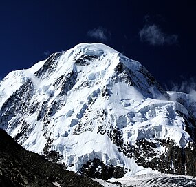
Lyskamm (German: Liskamm, formerly Lyskamm, literally "comb of the Lys"), also known as Silberbast (literally "silver bast"),[3][4] is a mountain (4,527 m (14,852 ft)) in the Pennine Alps lying on the border between Switzerland and Italy. It consists of a five-kilometre-long ridge with two distinct peaks. The mountain has gained a reputation for seriousness because of the many cornices lying on the ridge and the frequent avalanches, thus leading to its nickname the Menschenfresser ("people eater").
Contents
1 Geography
2 Climbing history
3 Climbing routes
4 Bibliography
5 References
6 External links
Geography

Liskamm from Western Liskamm
Because of its modest prominence (376 m), Liskamm is sometimes considered to be part of the extended Monte Rosa group (in fact the Dufourspitze is only 107 metres higher). But visually Liskamm is a huge massif, composed of two summits: the Eastern Liskamm and the lower Western Liskamm, separated by a 1 kilometre (0.62 mi) long ridge, both lying on the border between the Swiss canton of Valais (north) and the Italian region of the Aosta Valley (south).
The northern side of the mountain is an impressive 1,100 metres (3,600 ft) ice-covered wall, rising up from the Grenzgletscher. The gentler southern side rises only a few hundred metres above the glacier of the same name: Lysgletscher.
Climbing history
The eastern and higher of the two peaks is 4,527 m, and was first ascended in 1861 from the Lisjoch up the east ridge by a 14-man team (seven Englishmen, one Scotsman, and six Swiss guides) led by J. F. Hardy and including William Edward Hall. Others in the party included A. C. Ramsey, F. Sibson, T. Rennison, J. A. Hudson, C. H. Pilkington and R. M. Stephenson. The guides were Franz Josef Lochmatter (1825-1897) of St. Niklaus in the canton Valais, J.-P. Cachet, K. Kerr, S. Zumtaugwald, P. and J.-M. Perren.[5]

Liskamm above the Grenzgletscher (English: Border Glacier)
The ridge as a whole (as well as the western summit) was first traversed three years later by Leslie Stephen, Edward N. Buxton, Jakob Anderegg and Franz Biener.[5]
The first attempt to climb the imposing north-east face was made in 1880 by the brothers Kalbermatten. They were carried down to the glacier by an avalanche but they survived the accident. On 9 August 1890, L. Norman-Neruda with guides Christian Klucker and J. Reinstadler were the first to reach the summit (Liskamm East) by the north face, by what is now known as the "Norman-Neruda route".[5] The first winter ascent of this route was made on 11 March 1956 by C. Fosson and O. Frachey.[6]
In 1907, Geoffrey Winthrop Young and his guide traversed the whole ridge two times. Young wanted to traverse the ridge from the Nordend to the Breithorn. They started from Riffelalp at midnight and finished the traverse of the Monte Rosa massif at midday. But after the traverse of the Liskamm and Castor the guide was too tired. Young, who was very disappointed, convinced him to go back by the Lisjoch before descending to Zermatt, implying a second traverse on the Liskamm. Young even wanted to continue back to the Nordend but his guide refused to prolong the journey.[5]
Climbing routes
The normal route starts from the Lisjoch, which can be accessed from the Gnifetti Hut (3,650 m) or from the Monte Rosa Hut (2,883 m). The route follows the route taken by the first ascensionist.
The mountain is often climbed as a traverse from the Feliksjoch (West), to the Lisjoch (East) or vice versa. The traverse consists mostly of a narrow, snow-covered ridge, with some scrambling over rocks. In good conditions, this route is fairly easy and objectively safe, however in bad snow conditions and/or bad visibility, the ridge can be challenging because of large, sometimes double, cornices, mainly on the southern side of the ridge.

View from the Liskamm Nase (south side)
Bibliography
W. E. Hall (1870) "The fatal accident on the Lyskamm", Alpine Journal, 5: 23–32
References
^ Retrieved from the Swisstopo topographic maps. The key col is the Lisjoch (4,151 m).
^ Retrieved from Google Earth. The nearest point of higher elevation is west of the Dufourspitze.
^ "Liskamm". www.zermatt.ch. Retrieved 6 March 2016..mw-parser-output cite.citation{font-style:inherit}.mw-parser-output q{quotes:"""""""'""'"}.mw-parser-output code.cs1-code{color:inherit;background:inherit;border:inherit;padding:inherit}.mw-parser-output .cs1-lock-free a{background:url("//upload.wikimedia.org/wikipedia/commons/thumb/6/65/Lock-green.svg/9px-Lock-green.svg.png")no-repeat;background-position:right .1em center}.mw-parser-output .cs1-lock-limited a,.mw-parser-output .cs1-lock-registration a{background:url("//upload.wikimedia.org/wikipedia/commons/thumb/d/d6/Lock-gray-alt-2.svg/9px-Lock-gray-alt-2.svg.png")no-repeat;background-position:right .1em center}.mw-parser-output .cs1-lock-subscription a{background:url("//upload.wikimedia.org/wikipedia/commons/thumb/a/aa/Lock-red-alt-2.svg/9px-Lock-red-alt-2.svg.png")no-repeat;background-position:right .1em center}.mw-parser-output .cs1-subscription,.mw-parser-output .cs1-registration{color:#555}.mw-parser-output .cs1-subscription span,.mw-parser-output .cs1-registration span{border-bottom:1px dotted;cursor:help}.mw-parser-output .cs1-hidden-error{display:none;font-size:100%}.mw-parser-output .cs1-visible-error{font-size:100%}.mw-parser-output .cs1-subscription,.mw-parser-output .cs1-registration,.mw-parser-output .cs1-format{font-size:95%}.mw-parser-output .cs1-kern-left,.mw-parser-output .cs1-kern-wl-left{padding-left:0.2em}.mw-parser-output .cs1-kern-right,.mw-parser-output .cs1-kern-wl-right{padding-right:0.2em}
^ Swindin, Les; Flemming, Peter (1999). Valais Alps East:Selected Climbs. The Alpine Club. p. 150. ISBN 978-0900523625.
^ abcd Helmut Dumler,Willi P. Burkhardt, Les 4000 des Alpes,
ISBN 2-7003-1305-4
^ Collomb, Robin G., Pennine Alps Central, London: Alpine Club, 1975, p. 92
External links
| Wikimedia Commons has media related to Lyskamm. |
- Liskamm on Peakbagger.com
- Liskamm on SummitPost
Italian route account from south - Czech and English


