Davis, California
Davis, California | ||
|---|---|---|
City | ||
 Downtown Davis | ||
| ||
| Motto(s): The City of All Things Right and Relevant | ||
 Location of Davis in Yolo County, California | ||
 Davis, California Location in the United States | ||
| Coordinates: 38°33′14″N 121°44′17″W / 38.55389°N 121.73806°W / 38.55389; -121.73806Coordinates: 38°33′14″N 121°44′17″W / 38.55389°N 121.73806°W / 38.55389; -121.73806 | ||
| Country | United States | |
| State | California | |
| County | Yolo | |
| Rail depot | 1868 | |
| Incorporated | March 28, 1917[1] | |
| Government | ||
| • Mayor | Brett Lee[2] | |
| • State senator | Bill Dodd (D)[3] | |
| • Assemblymember | Cecilia Aguiar-Curry (D)[3] | |
| • U.S. rep. | John Garamendi (D)[4] | |
| Area [5] | ||
| • Total | 9.92 sq mi (25.70 km2) | |
| • Land | 9.89 sq mi (25.61 km2) | |
| • Water | 0.04 sq mi (0.09 km2) 0.32% | |
| Elevation [6] | 52 ft (16 m) | |
| Population (2010)[7] | ||
| • Total | 65,622 | |
| • Estimate (2016)[8] | 68,111 | |
| • Density | 6,888.95/sq mi (2,659.82/km2) | |
| Time zone | UTC−8 (Pacific) | |
| • Summer (DST) | UTC−7 (PDT) | |
ZIP codes[9] | 95616–95618 | |
| Area code | 530 | |
FIPS code | 06-18100 | |
GNIS feature IDs | 277498, 2410296 | |
| Website | cityofdavis.org | |
Davis, formerly known as Davisville,[10] is a city in the U.S. state of California and the most populous city in Yolo County. It had a population of 65,622 in 2010,[11] not including the on-campus population of the University of California, Davis, which was over 9,400 (not including students' families) in 2016.[12] As of 2016, there were 35,186 students enrolled at the university.[13]
Contents
1 History
2 Geography and environment
2.1 Location
2.2 Climate
2.3 Neighborhoods
2.4 Environment
3 Demographics
3.1 2010
3.2 2000
4 Economy
4.1 Top employers
4.2 Davis Dollars
5 Bicycling
6 Sights and culture
6.1 Whole Earth Festival
6.2 Celebrate Davis
6.3 Picnic Day
6.4 Davis Transmedia Art Walk
6.5 Manetti Shrem Museum of Art
6.6 Mondavi Center
6.7 UC Davis Arboretum
6.8 The Domes
6.9 Farmers Market
6.10 Media
6.11 Toad Tunnel
6.12 Davis Food Coop
7 Education
7.1 University of California
7.2 D-Q University
7.3 Other colleges
7.4 Public schools
7.5 Private schools
7.6 Private post-secondary schools
8 Notable natives and residents
9 Sister cities
10 See also
11 References
12 External links
History
Davis grew into a Southern Pacific Railroad depot built in 1868. It was then known as "Davisville", named after Jerome C. Davis, a prominent local farmer. However, the post office at Davisville shortened the town name to "Davis" in 1907. The name stuck, and the city of Davis was incorporated on March 28, 1917.[14]
From its inception as a farming community, Davis has been known for its contributions to agricultural policy along with veterinary care and animal husbandry. Following the passage of the University Farm Bill in 1905 by the California State Legislature, Governor George Pardee selected Davis out of 50 other sites as the future home to the University of California's University Farm, officially opening to students in 1908.[15] The farm, later renamed the Northern Branch of the College of Agriculture in 1922, was upgraded to become the seventh UC general campus, the University of California, Davis, in 1959.
Geography and environment
Location
Davis is located in Yolo County, California, 11 mi (18 km) west of Sacramento, 70 mi (113 km) northeast of San Francisco, 385 mi (619 km) north of Los Angeles, at the intersection of Interstate 80 and State Route 113. Neighboring towns include Dixon, Winters, Woodland, and West Sacramento.
Davis lies in the Sacramento Valley, the northern portion of the Central Valley, in Northern California, at an elevation of about 52 feet (16 m) above sea level.
According to the United States Census Bureau, the city has a total area of 10.5 square miles (27 km2). 10.4 square miles (27 km2) of it is land and 0.04 square miles (0.10 km2) of it (0.19%) is water.
The topography is flat, which has helped Davis to become known as a haven for bicyclists.[16][17]
Climate
The Davis climate resembles that of nearby Sacramento and is typical of California's Central Valley Mediterranean climate region: dry, hot summers and cool, rainy, winters. It is classified as a Köppen Csa climate. Average temperatures range from 46 °F (8 °C) in December and January to 75 °F (24 °C) in July and August. Thick ground fog called tule fog settles into Davis during late fall and winter. This fog can be dense with visibility nearly zero. As in other areas of northern California, the tule fog is a leading cause of road accidents in the winter season.
Record temperatures range from a high of 116 °F (47 °C) on July 17, 1925, to a low of 12 °F (−11 °C) on December 11, 1932.[18]
| Climate data for Davis, California (1893–2016 normals) | |||||||||||||
|---|---|---|---|---|---|---|---|---|---|---|---|---|---|
| Month | Jan | Feb | Mar | Apr | May | Jun | Jul | Aug | Sep | Oct | Nov | Dec | Year |
| Average high °F (°C) | 54.0 (12.2) | 60.4 (15.8) | 65.8 (18.8) | 72.4 (22.4) | 80.5 (26.9) | 88.3 (31.3) | 94.0 (34.4) | 92.8 (33.8) | 88.6 (31.4) | 78.9 (26.1) | 65.5 (18.6) | 54.9 (12.7) | 74.7 (23.7) |
| Average low °F (°C) | 36.9 (2.7) | 39.7 (4.3) | 41.8 (5.4) | 44.5 (6.9) | 49.1 (9.5) | 53.7 (12.1) | 55.4 (13) | 54.0 (12.2) | 52.4 (11.3) | 47.4 (8.6) | 40.7 (4.8) | 36.9 (2.7) | 46.0 (7.8) |
| Average precipitation inches (mm) | 3.80 (96.5) | 3.22 (81.8) | 2.36 (59.9) | 1.18 (30) | 0.46 (11.7) | 0.19 (4.8) | 0.01 (0.3) | 0.03 (0.8) | 0.24 (6.1) | 0.83 (21.1) | 1.92 (48.8) | 3.31 (84.1) | 17.55 (445.8) |
| Source: [18] | |||||||||||||
Neighborhoods
Davis is internally divided by two freeways (Interstate 80 and State Route 113), a north–south railroad (California Northern), an east-west mainline (Union Pacific) and several major streets. The city is unofficially divided into six main districts made up of smaller neighborhoods (often originally named as housing subdivisions):

Part of the UC Davis Arboretum
- Central Davis, north of Fifth Street and Russell Boulevard, south of Covell Blvd., east of SR 113, and west of the railroad tracks running along G Street. Within these boundaries is the officially denoted neighborhood of Old North Davis, which is sometimes also considered part of Downtown.[19]
- Downtown Davis, roughly the numbered-and-lettered grid north of I-80, south of Fifth Street, east of A Street, and west of the railroad tracks, including the Aggie Village and Olive Drive areas.[citation needed]
- East Davis, north of I-80, south of Covell Blvd., and east of the railroad tracks. It includes the older, 'inner' East Davis of lettered streets and neighborhoods such as Davis Manor, Chestnut, and Rancho Yolo, as well as more distinctly identified (in some cases walled-in) subdivisions such as Mace Ranch, Lake Alhambra Estates, and Wildhorse.[citation needed]
- North Davis, north of Covell Blvd. North Davis includes Covell Park, Senda Nueva, Northstar, and North Davis Farms.
- South Davis, south of I-80, and includes Willowbank. El Macero, California, although outside the city limits, is sometimes considered part of South Davis; El Macero is part of the Davis Joint Unified School District, and El Macero children who attend public schools attend Davis' public schools.[citation needed]
- West Davis, north of I-80 and west of SR 113. West Davis includes Westwood, Evergreen, Aspen, Stonegate (west of Lake Boulevard and including Stonegate Lake and the Stonegate Country Club) and the eco-friendly Village Homes development, known for its solar-powered houses. Davis in 1984 claimed to be America's First Solar City (Let it Shine - The 6000 Year Story of Solar Energy -John Perlin 2013)[verification needed] Babcock Ranch 34 years later makes the false claim.[citation needed]
The University of California, Davis is located south of Russell Boulevard and west of A Street and then south of 1st Street. The land occupied by the university is not incorporated within the boundaries of the city of Davis and lies within both Yolo and Solano Counties.
Environment
Local energy planning began in Davis after the energy crisis of 1973. A new building code promoted energy efficiency. Energy use in buildings decreased dramatically and in 1981 Davis citizens won a $100, 000 prize from utility PG&E, for cutting electricity use during the summer peak.[20]
On November 14, 1984, the Davis City Council declared the city to be a nuclear-free zone.[21] In 1998, the City passed a 'Dark Skies' ordinance in an effort to reduce light pollution in the night sky.[22]
In 2013, Davis became part of the state Cool Roof Initiative with 'CoolDavis' campaign, requiring all new roofing projects to meet Cool Roof Rating Council (CRRC) requirements including the installation of light colored roofs. The aim is to reflect more sunlight back into space via the albedo effect, and reduce the amount of heat absorbed in hopes of limiting climate change.[23]
Demographics
| Historical population | |||
|---|---|---|---|
| Census | Pop. | %± | |
| 1880 | 441 | — | |
| 1890 | 547 | 24.0% | |
| 1920 | 939 | — | |
| 1930 | 1,243 | 32.4% | |
| 1940 | 1,672 | 34.5% | |
| 1950 | 3,554 | 112.6% | |
| 1960 | 8,910 | 150.7% | |
| 1970 | 23,488 | 163.6% | |
| 1980 | 36,640 | 56.0% | |
| 1990 | 46,209 | 26.1% | |
| 2000 | 60,308 | 30.5% | |
| 2010 | 65,622 | 8.8% | |
| Est. 2016 | 68,111 | [8] | 3.8% |
| U.S. Decennial Census[24] | |||
Davis is part of the Sacramento–Arden-Arcade–Roseville Metropolitan Statistical Area.
2010
The 2010 United States Census[25] reported that Davis had a population of 65,622. The population density was 6,615.8 people per square mile (2,554.4/km²). The racial makeup of Davis was 42,571 (64.9%) White, 1,528 (2.3%) African American, 339 (0.5%) Native American, 14,355 (21.9%) Asian, 136 (0.2%) Pacific Islander, 3,121 (4.8%) from other races, and 3,572 (5.4%) from two or more races. Hispanic or Latino of any race were 8,172 persons (12.5%).
In 2006, Davis was ranked as the second most educated city (in terms of the percentage of residents with graduate degrees) in the US by CNN Money Magazine,[26] after Arlington, Virginia.[27]
Davis' Asian population of 14,355 was apportioned among 1,631 Indian Americans, 6,395 Chinese Americans, 1,560 Korean Americans, 1,185 Vietnamese Americans, 1,033 Filipino Americans, 953 Japanese Americans, and 1,598 other Asian Americans.[28]
Davis' Hispanic and Latino population of 8,172 was apportioned among 5,618 Mexican American, 221 Puerto Rican American, 80 Cuban American, and 2,253 other Hispanic and Latino.[28]
| Davis, California population reported at 2010 United States Census[29][30] | |||
|---|---|---|---|
Race | Total Population | Not Hispanic or Latino | Hispanic or Latino |
White | 42,571 | 38,641 | 3,930 |
African American | 1,528 | 1,415 | 113 |
Native American | 339 | 166 | 173 |
Asian | 14,355 | 14,213 | 142 |
Pacific Islander | 136 | 120 | 16 |
other races | 3,121 | 181 | 2,940 |
two or more races | 3,572 | 2,714 | 858 |
The Census reported that 63,522 people (96.8% of the population) lived in households, 1,823 (2.8%) lived in non-institutionalized group quarters, and 277 (0.4%) were institutionalized.
There were 24,873 households, of which 6,119 (24.6%) had children under the age of 18 living in them, 9,343 (37.6%) were opposite-sex married couples living together, 1,880 (7.6%) had a female householder with no husband present, and 702 (2.8%) had a male householder with no wife present. There were 1,295 (5.2%) unmarried opposite-sex partnerships, and 210 (0.8%) same-sex married couples or partnerships. 5,952 households (23.9%) were made up of individuals and 1,665 (6.7%) had someone living alone who was 65 years of age or older. The average household size was 2.55. There were 11,925 families (47.9% of all households); the average family size was 2.97.
The population age and sex distribution was 10,760 people (16.4%) under the age of 18, 21,757 people (33.2%) aged 18 to 24, 14,823 people (22.6%) aged 25 to 44, 12,685 people (19.3%) aged 45 to 64, and 5,597 people (8.5%) who were 65 years of age or older. The median age was 25.2 years. For every 100 females, there were 90.5 males. For every 100 females age 18 and over, there were 88.0 males.
There were 25,869 housing units with an average density of 2,608.0 per square mile (1,007.0/km²), of which 10,699 (43.0%) were owner-occupied, and 14,174 (57.0%) were occupied by renters. The homeowner vacancy rate was 0.9%; the rental vacancy rate was 3.5%. 27,594 people (42.0% of the population) lived in owner-occupied housing units and 35,928 people (54.7%) lived in rental housing units.
2000
As of the United States 2000 Census,[31] there were 60,308 people, 22,948 households, and 11,290 families residing in the city. The population density was 5,769.2 inhabitants per square mile (2,228.2/km2). There were 23,617 housing units at an average density of 2,259.3 per square mile (872.6/km2). The racial composition of the city was 70.07% White, 2.35% Black or African American, 0.67% Native American, 17.5% Asian, 0.24% Pacific Islander, 4.26% from other races, and 4.87% from two or more races. 9.61% of the population were Hispanic or Latino of any race.[32]
There were 22,948 households of which 26.4% had children under the age of 18 living with them, 38.3% were married couples living together, 8.2% had a female householder with no husband present, and 50.8% were non-families. 25.0% of all households were composed of individuals and 5.2% had someone living alone who was 65 years of age or older. The average household size was 2.50 and the average family size was 3.00.
In the city, the population age distribution was 18.6% under the age of 18, 30.9% from 18 to 24, 27.1% from 25 to 44, 16.7% from 45 to 64, and 6.6% who were 65 years of age or older. The median age was 25 years. For every 100 females, there were 91.2 males. For every 100 females age 18 and over, there were 87.8 males.
The median income for a household in the city was $42,454, and the median income for a family was $74,051. Males had a median income of $51,189 versus $36,082 for females. The per capita income for the city was $22,937. About 5.4% of families and 24.5% of the population were below the poverty line, including 6.8% of those under age 18 and 2.8% of those age 65 or over.
This city of approximately 62,000 people abuts a university campus of 32,000 students. Although the university's land is not incorporated within the city, many students live off-campus in the city.
Economy
The California Northern Railroad is based in Davis.
Top employers
According to the City's 2011 Comprehensive Annual Financial Report,[33] the top employers in the city are:
| # | Employer | # of Employees |
|---|---|---|
| 1 | University of California, Davis | 28,411 |
| 2 | Davis Joint Unified School District | 972 |
| 3 | City of Davis | 492 |
| 4 | Sutter Davis Hospital | 396 |
| 5 | Safeway | 200 |
| 6 | United States Department of Agriculture | 200 |
| 7 | Pacific Gas & Electric | 200 |
| 8 | Target | 191 |
| 9 | Nugget Markets | 166 |
| 10 | Davis Food Co-op | 133 |
Davis Dollars
A community currency scheme is in use in Davis, called Davis Dollars.[34]
Bicycling
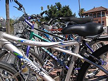
Bikes in front of the Davis Amtrak station
Bicycling has been a popular mode of transportation in Davis for decades, particularly among school-age children and UC Davis students. In 2010, Davis became the new home of the United States Bicycling Hall of Fame.
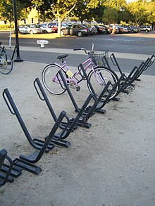
Davis racks
Bicycle infrastructure became a political issue in the 1960s, culminating in the election of a pro-bicycle majority to the City Council in 1966.[35] By the early 1970s, Davis became a pioneer in the implementation of cycling facilities. As the city expands, new facilities are usually mandated. As a result, Davis residents today enjoy an extensive network of bike lanes, bike paths, and grade-separated bicycle crossings.[36][37][38] The flat terrain and temperate climate are also conducive to bicycling.

Bicycle crossing over Covell Blvd.
In 2005 the Bicycle-Friendly Community program of the League of American Bicyclists recognized Davis as the first Platinum Level city in the US[39][40] In March 2006, Bicycling Magazine named Davis the best small town for cycling in its compilation of "America's Best Biking Cities."[41] Bicycling appears to be declining among Davis residents: from 1990 to 2000, the US Census Bureau reported a decline in the fraction of commuters traveling by bicycle, from 22 percent to 15 percent.[42] This resulted in the reestablishment of the city's Bicycle Advisory Commission and creation of advocate groups such as "Davis Bicycles!". In 2016, Fifth Street, a main road in Davis was converted from four lanes to two lanes to allow for bicycle lanes and encourage more bicycling.
In 1996, 2001, 2006, and 2009 the UC Davis "Cal Aggie Cycling" Team won the national road cycling competition.[43] The team also competes off-road and on the track, and has competed in the national competitions of these disciplines. In 2007, UC Davis also organized a record breaking bicycle parade numbering 822 bicycles.[44]
Sights and culture
Whole Earth Festival
A continuous stream of bands, speakers and various workshops occurs throughout Mother's Day weekend on each of Whole Earth Festival's (WEF) three stages and other specialty areas. The WEF is organized entirely by UC Davis students, in association with the Associated Students of UC Davis, the Experimental College, and the university.
Celebrate Davis
Celebrate Davis is the annual free festival held by the Davis Chamber of Commerce. It features booths by Davis businesses, live music, food vendors, live animals, activities like rock climbing and zip-line. It concludes with fireworks after dark. Parking is problematic, so most people ride their bikes and use the free valet parking.
Picnic Day
Picnic Day is an annual event at the University of California, Davis and is always held on the third Saturday in April. It is the largest student-run event in the US. Picnic Day starts off with a parade, which features the UC Davis California Aggie Marching Band-uh!, and runs through campus and around downtown Davis and ends with the Battle of the Bands, which lasts until the last band stops playing (sometimes until 2 am). There are over 150 free events and over 50,000 attend every year. Other highlights include: the Dachshund races, a.k.a. the Doxie Derby, held in the Pavilion; the Davis Rock Challenge, the Chemistry Magic Show, and the sheep dog trials. Many departments have exhibits and demonstrations, such as the Cole Facility, which until recently showed a fistulated cow (a cow that has been fitted with a plastic portal (a "fistula") into its digestive system to observe digestion processes). Its name was "Hole-y Cow".
Davis Transmedia Art Walk
The Davis Transmedia Art Walk is a free—self-guided—public art tour includes 23 public murals, 16 sculptures, and 15 galleries and museums all in downtown Davis and the University of Davis campus. A free Davis Art Walk map serves as a detailed guide to the entire collection. The art pieces are all within walking distance of each other. The walk is a roughly circuitous path that can be completed within an hour or two. Every piece of art on the Art Walk has been embedded with an RFID chip. Using a cellphone that supports this technology, you access multimedia files that relate to each work. You can even leave a comment or "burn your own message" for other visitors to see. Artist hosted tours are held on the weekend by appointment only. To pick up a copy of the Davis Art Walk map, visit the Yolo County Visitors Bureau (132 E St., Suite 200; (530) 297-1900) or the John Natsoulas Center for the Arts (521 1st St.; (530) 756-3938).
Manetti Shrem Museum of Art
The Manetti Shrem Museum of Art, located on the UC Davis campus, opened on November 13, 2016 and carries on the legacy of the university's world-renowned first generation art faculty, which contributed to innovations in conceptual, performance and video art in the 1960s and 70s. The museum has generated nationwide attention with exhibits by artists such as Wayne Thiebaud, Bruce Nauman, John Cage, and Robert Arneson as well as its striking architecture, featuring a 50,000 square-foot “Grand Canopy” of perforated aluminum triangular beams, supported by 40 steel columns. Every year the museum exhibits works by graduating art students. The museum is free and hosts lecture series and events throughout the year, as well as weekend art studio activities for all ages.
Mondavi Center
The Mondavi Center, located on the UC Davis campus, is one of the biggest non-seasonal attractions to Davis. The Mondavi Center is a theater which hosts many world-class touring acts, including star performers such as Yo-Yo Ma and Cecilia Bartoli, and draws a large audience from Sacramento.
UC Davis Arboretum
The UC Davis Arboretum is an arboretum and botanical garden. Plants from all over the world grow in different sections of the park. There are notable oak and native plant collections and a small redwood grove. A small waterway spans the arboretum along the bed of the old North Fork of Putah Creek. Occasionally herons, kingfishers, and cormorants can be seen around the waterways, as well as the ever-present ducks. Tours of the arboretum led by volunteer naturalists are often held for grade-school children.
The Domes
The Domes, (AKA Baggins End Innovative Housing), is an on-campus cooperative housing community designed by project manager Ron Swenson and future student-residents in 1972. Consisting of 14 polyurethane foam-insulated fiberglass domes and located in the Sustainable Research Area at the western end of Orchard Road, it is governed by its 26 UCD student residents. It is one of the few student co-housing cooperative communities in the USA, and is an early example of the modern-day growing tiny house movement. The community has successfully resisted several threats to its continuation over the years.
Farmers Market
The Davis Farmers Market[45] is held every Wednesday evening and Saturday morning. Participants sell a range of fruits and vegetables, baked goods, dairy and meat products (often from certified organic farms), crafts, and plants and flowers. From April to October, the market hosts Picnic in the Park, with musical events and food sold from restaurant stands.[46]
The Davis Farmers Market won first place in the 2009, and second place in the 2010 America's Favorite Farmers Markets held by the American Farmland Trust under the large Farmers market classification.[47][48]
Media
Davis has one daily newspaper, The Davis Enterprise,[49] founded in 1897. UC Davis also has a weekly newspaper called The California Aggie which covers campus, local and national news. Davis Media Access, a community media center, is the umbrella organization of television station DCTV.[50] There are also numerous commercial stations broadcasting from nearby Sacramento. Davis has two community radio stations: KDVS 90.3 FM, on the University of California campus, and KDRT 95.7 FM, a subsidiary of Davis Media Access and one of the first low-power FM radio stations in the United States. Davis has the world's largest English-language local wiki, DavisWiki.
Toad Tunnel
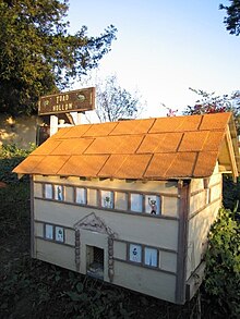
Entrance to the Toad Tunnel in front of the Post Office
Davis' Toad Tunnel is a wildlife crossing that was constructed in 1995 and has drawn much attention over the years, including a mention on The Daily Show. Because of the building of an overpass, animal lovers worried about toads being killed by cars commuting from South Davis to North Davis, since the toads hopped from one side of a dirt lot (which the overpass replaced) to the reservoir at the other end. After much controversy, a decision was made to build a toad tunnel, which runs beneath the Pole Line Road overpass which crosses Interstate 80. The project cost $14,000. The tunnel is 21 inches (53 cm) wide and 18 inches (46 cm) high.
The tunnel has created problems of its own. The toads originally refused to use the tunnel and so the tunnel was lit to encourage its use. The toads then died from the heat of the lamps inside the tunnel. Once through the tunnel, the toads also had to contend with birds who grew wise to the toad-producing hole in the ground.[citation needed] The exit to the toad tunnel has been decorated by the Postmaster to resemble a toad town.
Davis Food Coop
The Davis Food Coop is a Davis institution. Founded in 1972, this cooperative is presently owned and operated by over 9,000 members and families of the Davis Community. The Coop is a full service supermarket that has championed organic, healthy eating in the community, sponsoring community events including summer programs for children, cooking classes, and many other activities.
Education
University of California
The University of California, Davis, or UC Davis, a campus of the University of California, had a 2015 Fall enrollment of 36,104 students.[51] UC Davis has a dominant influence on the social and cultural life of the town.
D-Q University

Entrance and mural at D-Q University
Also known as Deganawidah-Quetzalcoatl University and much smaller than UC Davis, D-Q University was a two-year institution located on Road 31 in Yolo County 6.7 miles (11 km) west of State Route 113. This is just west of Davis near the Yolo County Airport. About four miles (6 km) to the west, the Road 31 exit from Interstate 505 is marked with cryptic signage, "DQU." The site is about 100 feet (30 m) above mean sea level (AMSL). NAD83 coordinates for the campus are 38°34′02″N 121°53′12″W / 38.56722°N 121.88667°W / 38.56722; -121.88667
The college closed in 2005. The curriculum was said to include heritage and traditional American Indian ceremonies. The 643 acres (2.60 km2) and 5 buildings were formerly a military reservation according to a National Park Service publication, Five Views. The full name of the school is included here so that readers can accurately identify the topic. According to some tribal members, use of the spelled-out name of the university can be offensive. People who want to be culturally respectful refer to the institution as D-Q University. Tribal members in appropriate circumstances may use the full name.
Other colleges
An off-campus branch of Sacramento City College is located in Davis. The satellite is located in West Village, an area built by UC Davis to house students and others affiliated with the university.
Public schools
Davis' public school system is administrated by the Davis Joint Unified School District.
The city has nine public elementary schools (North Davis, Birch Lane, Pioneer Elementary, Patwin, Cesar Chavez, Robert E. Willett, Marguerite Montgomery, Fred T. Korematsu at Mace Ranch, and Fairfield Elementary (which is outside the city limits but opened in 1866 and is Davis Joint Unified School District's oldest public school)). Davis has one school for independent study (Davis School for Independent Study), three public junior high schools (Ralph Waldo Emerson, Oliver Wendell Holmes, and Frances Harper), one main high school (Davis Senior High School), one alternative high school (Martin Luther King High School), and a small technology-based high school (Leonardo da Vinci High School). Cesar Chavez is a Spanish immersion school, with no English integration until the third grade. The junior high schools contain grades 7 through 9. Due to a decline in the school-age population in Davis, two of the elementary schools in south Davis may have their district boundaries changed, or magnet programs may be moved to equalize enrollment. Valley Oak was closed after the 2007–08 school year, and their campus was granted to Da Vinci High (which had formerly been located in the back of Davis Senior High's campus) and a special-ed preschool. On average, class size is about 25 students: 1 teacher.[52]
At one time, Chavez and Willett were incorporated together to provide elementary education K–6 to both English-speaking and Spanish immersion students in West Davis. César Chávez served grades K–3 and was called West Davis Elementary, and Robert E. Willett (named for a long-time teacher at the school, now deceased) served grades 4–6 and was known as West Davis Intermediate. Willett now serves K–6 English-speaking students, and Chavez supports the Spanish immersion program for K–6.
Private schools
Peregrine School (Preschool and Elementary)- Merryhill School (K–8)
- Saint James School (K–8)
- Grace Valley Christian Academy (K–9)
Davis Waldorf School (Pre-K–8)
Private post-secondary schools
OnSite Medical Service, Inc. (Emergency Medical Technician Training Center; CPR, First Aid Training Site for American Heart Association)[53]
Notable natives and residents
These are some notable Davis residents, other than UC Davis faculty who were not previously from Davis.
Karin Argoud, actress
Samuel G. Armistead, anthropologist and linguist
Ruth Asmundson, former mayor of Davis
Peter S. Beagle, author, The Last Unicorn
Robert Todd Carroll (born 1945), publisher of The Skeptic's Dictionary and fellow for Committee for Skeptical Inquiry
Isaac Skinner Chiles, early pioneer[54]
Joseph Ballinger Chiles, trail blazer and early pioneer
Tony Cline, Jr., NFL tight end
Antoinette Clinton, AKA Butterscotch, musician
Dianne Comini, former US women's chess champion[55]
Kim Conley, 2012 Olympian, track and field
Joe Craven, musician
Denise Curry, basketball player
Jerome C. Davis, state figure and pioneer, and namesake of Davis
Josh Davis, AKA DJ Shadow, famous for his critically acclaimed sample based instrumental Hip-Hop
Delaine Eastin, former California State Superintendent of Public Instruction
Tony Fields, actor, dancer; Davis High School alumnus. Fields is best known in his tenure as a Solid Gold Dancer (1979-1984) and his film roles of Alan DeLuca in the 1985 movie version of A Chorus Line and Sammi Curr in the 1986 cult horror film Trick Or Treat.
Jason Fisk, former NFL defensive tackle
Karen Joy Fowler, author
Michael Franti, musician
Todd Gogulski, former professional bicycle road racer and TV commentator for Universal Sports
Carol Greider, molecular biologist and Nobel Laureate (at Johns Hopkins), raised in Davis
Myril Hoag, MLB outfielder, 3-time World Series champion
Rita Hosking, musician
Nyjah Huston, professional skateboarder
John Lescroart, author
Deborah Madison, chef, author
Mike May, entrepreneur and athlete, regained sight after decades of complete blindness
Barry Melton, musician
Gina Miles, 2008 Beijing Olympic silver medalist, equestrian
Hasan Minhaj, comedian
Gabe Newell, co-founder of Valve
Dickie Peterson, musician
Orange Phelps, Oregon businessman and politician
Kim Stanley Robinson, science-fiction author; famous works include Mars trilogy
Stephen Robinson, astronaut (received bachelor's degree from UC Davis, 1978)
Beth Rodden, professional rock climber
Paul Scheuring, screenwriter (Prison Break, A Man Apart)
Dave Scott, triathlete, six-time Ironman Triathlon world champion
Sean Stewart, author
Charles Tart, parapsychologist
Helen Thomson, state and county politician
Nick Watney, PGA Tour professional golfer
Zach Weiner, web comic author and illustrator
Andrew Weir, author of The Martian
Paul Whaley, drummer for the band Blue Cheer
Mike Wise, NFL defensive end
Lois Wolk, state politician
Paul Wulff, former Washington State football head coach
Mariko Yamada, state politician
Martin Yan, cooking show host
Sophia Yin, veterinarian, animal trainer and author
Gary Lee Yoder, musician, part of several 1960s psychedelic rock bands
Ladule Lako LoSarah is an American-born South Sudanese international[56]footballer currently with FC Inter Leipzig of the German NOFV-Oberliga.[57]
Sister cities
Davis has eight sister cities[58]
 Inuyama, Japan
 Los Baños, Philippines
Muñoz, Philippines
 Qufu, People's Republic of China
 Rutilio Grande, El Salvador
 Sangju, South Korea
 Uman, Ukraine
Wuxi, People's Republic of China
See also
- Lake Davis, California
References
^ "California Cities by Incorporation Date". California Association of Local Agency Formation Commissions. Archived from the original (Word) on November 3, 2014. Retrieved August 25, 2014..mw-parser-output cite.citation{font-style:inherit}.mw-parser-output q{quotes:"""""""'""'"}.mw-parser-output code.cs1-code{color:inherit;background:inherit;border:inherit;padding:inherit}.mw-parser-output .cs1-lock-free a{background:url("//upload.wikimedia.org/wikipedia/commons/thumb/6/65/Lock-green.svg/9px-Lock-green.svg.png")no-repeat;background-position:right .1em center}.mw-parser-output .cs1-lock-limited a,.mw-parser-output .cs1-lock-registration a{background:url("//upload.wikimedia.org/wikipedia/commons/thumb/d/d6/Lock-gray-alt-2.svg/9px-Lock-gray-alt-2.svg.png")no-repeat;background-position:right .1em center}.mw-parser-output .cs1-lock-subscription a{background:url("//upload.wikimedia.org/wikipedia/commons/thumb/a/aa/Lock-red-alt-2.svg/9px-Lock-red-alt-2.svg.png")no-repeat;background-position:right .1em center}.mw-parser-output .cs1-subscription,.mw-parser-output .cs1-registration{color:#555}.mw-parser-output .cs1-subscription span,.mw-parser-output .cs1-registration span{border-bottom:1px dotted;cursor:help}.mw-parser-output .cs1-hidden-error{display:none;font-size:100%}.mw-parser-output .cs1-visible-error{font-size:100%}.mw-parser-output .cs1-subscription,.mw-parser-output .cs1-registration,.mw-parser-output .cs1-format{font-size:95%}.mw-parser-output .cs1-kern-left,.mw-parser-output .cs1-kern-wl-left{padding-left:0.2em}.mw-parser-output .cs1-kern-right,.mw-parser-output .cs1-kern-wl-right{padding-right:0.2em}
^ "City Council – Who's Who". City of Davis. Retrieved August 26, 2018.
^ ab "Statewide Database". UC Regents. Archived from the original on February 1, 2015. Retrieved October 14, 2014.
^ "California's 3rd Congressional District - Representatives & District Map". Civic Impulse, LLC. Retrieved March 1, 2013.
^ "2016 U.S. Gazetteer Files". United States Census Bureau. Archived from the original on August 24, 2017. Retrieved July 19, 2017.
^ "Davis". Geographic Names Information System. United States Geological Survey. Retrieved October 14, 2014.
^ "Davis (city) QuickFacts". United States Census Bureau. Archived from the original on August 18, 2012. Retrieved February 23, 2015.
^ ab "Population and Housing Unit Estimates". Archived from the original on May 29, 2017. Retrieved June 9, 2017.
^ "ZIP Code(tm) Lookup". United States Postal Service. Archived from the original on November 16, 2014. Retrieved December 4, 2014.
^ File:Map of railroad connections to Benicia and the San Francisco Bay area 1885.jpg
^ Bureau, U.S. Census. "American FactFinder - Results". factfinder2.census.gov. Archived from the original on December 17, 2012. Retrieved April 28, 2018.
^ "Campus Tomorrow". campustomorrow.ucdavis.edu. Archived from the original on September 26, 2017. Retrieved April 28, 2018.
^ "Current Student Enrollments | Budget & Institutional Analysis". budget.ucdavis.edu. Retrieved 2018-07-12.
^ "Jerome C. Davis - Davis - LocalWiki". daviswiki.org. Archived from the original on October 15, 2017. Retrieved April 28, 2018.
^ Davis: Historical Overview Archived February 14, 2009, at the Wayback Machine. University of California History Retrieved on 02-17-08
^ Reid, Carlton (August 3, 2015). "Davis, California – the American city which fell in love with the bicycle". the Guardian. Archived from the original on July 1, 2017. Retrieved April 28, 2018.
^ "The Best Communities For Bicycling". wired.com. Archived from the original on May 25, 2017. Retrieved April 28, 2018.
^ ab "DAVIS 1 WSW, CALIFORNIA – Climate Summary". Wrcc.dri.edu. Archived from the original on August 11, 2014. Retrieved June 19, 2013.
^ "Central Davis". LocalWiki. Archived from the original on April 13, 2017. Retrieved March 17, 2017.
^ Lovins on the Soft Path: A Guide to the Film, RMI, 1985.
^ "Nuclear Free Zone - Davis - LocalWiki". daviswiki.org. Archived from the original on May 25, 2017. Retrieved April 28, 2018.
^ McCarthy, E."'Dark skies' law casts new light on buildings" Archived February 19, 2014, at the Wayback Machine. Sacramento Business Journal, 31 Jan. 1999.
^ "Energy Archives - Cool Davis". Cool Davis. Retrieved 2018-07-12.
^ "Census of Population and Housing". Census.gov. Archived from the original on May 12, 2015. Retrieved June 4, 2015.
^ "2010 Census Interactive Population Search: CA - Davis city". U.S. Census Bureau. Archived from the original on January 29, 2016. Retrieved July 12, 2014.
^ "Personal finance advice, ideas, tips and financial planning – Money Magazine on CNNMoney". Money.cnn.com. May 20, 2013. Archived from the original on June 18, 2013. Retrieved June 19, 2013.
^ MONEY magazine: Best places to live 2006: Top 25 Most Educated Archived May 11, 2012, at the Wayback Machine.
^ ab "Census 2010: Table 3 – Total Population by Race, including Detailed Asian Race". California Department of Finance. Archived from the original (Excel) on September 28, 2011. Retrieved May 31, 2010.
^ "Archived copy". Archived from the original on December 17, 2012. Retrieved August 4, 2011.CS1 maint: Archived copy as title (link) US Census Bureau
^ "Census 2010: Table 3A – Total Population by Race (Hispanic exclusive) and Hispanic or Latino: 2010". California Department of Finance. Archived from the original (Excel) on December 3, 2013. Retrieved May 31, 2010.
^ "American FactFinder". United States Census Bureau. Archived from the original on September 11, 2013. Retrieved 2008-01-31.
^ Factfinder.census.gov Archived October 19, 2007, at the Wayback Machine. Retrieved on May 15, 2007
^ City of Davis Comprehensive Annual Financial Report, Fiscal Year Ended June 30, 2011 Archived May 18, 2013, at the Wayback Machine.link= May 18, 2013, at the Wayback Machine.
Retrieved October 24, 2012
^ Davis Dollars (n.d.). "Davis Dollars". unknown. Archived from the original on October 4, 2016. Retrieved December 6, 2016.
^ http://www.ci.davis.ca.us/pw/pdfs/2006_BikePlan_withMaps.pdf Archived June 14, 2007, at the Wayback Machine.link= June 14, 2007, at the Wayback Machine.
Ci.davis.ca.us Retrieved on May 15, 2007
^ "Bike Lanes - Davis - LocalWiki". daviswiki.org. Archived from the original on May 25, 2017. Retrieved April 28, 2018.
^ "Bike Paths - Davis - LocalWiki". daviswiki.org. Archived from the original on May 25, 2017. Retrieved April 28, 2018.
^ "Bike Paths - Davis - LocalWiki". daviswiki.org. Archived from the original on May 25, 2017. Retrieved April 28, 2018.
^ http://www.bikeleague.org/programs/bicyclefriendlyamerica/communities/bfc_davis.php Archived October 11, 2010, at the Wayback Machine. Bikeleague.org Retrieved on September 27, 2010
^ Bike League press release Archived December 29, 2010, at the Wayback Machine., citing Davis as first platinum community
^ http://www.davisenterprise.com/articles/2006/01/29/news/339new5.txt Davisenterprise.com Retrieved on May 15, 2007
^ http://factfinder.census.gov/servlet/DatasetMainPageServlet?_program=DEC&_submenuId=datasets_0&_lang=en Archived April 27, 2007, at the Wayback Machine. Factfinder.census.gov Retrieved on May 15, 2007
^ "Cal Aggie Cycling". ucdavis.edu. Archived from the original on December 30, 2006. Retrieved April 28, 2018.
^ "World's Largest Bicycle Parade - Davis - LocalWiki". daviswiki.org. Archived from the original on May 25, 2017. Retrieved April 28, 2018.
^ "At The Market! — Davis Farmers' Market". www.davisfarmersmarket.org. Archived from the original on March 10, 2018. Retrieved April 28, 2018.
^ "Picnic In The Park - Davis - LocalWiki". daviswiki.org. Archived from the original on May 25, 2017. Retrieved April 28, 2018.
^ "I Love My Farmers Market Celebration – American Farmland Trust". Action.farmland.org. Archived from the original on July 11, 2011. Retrieved June 19, 2013.
^ [1] Archived March 3, 2012, at the Wayback Machine.
^ "Davis Enterprise". Davis Enterprise. Retrieved April 28, 2018.
^ "Davis Community Television - Davis - LocalWiki". daviswiki.org. Archived from the original on May 25, 2017. Retrieved April 28, 2018.
^ "Fall enrollment at a glance". universityofcalifornia.edu. December 20, 2017. Archived from the original on March 20, 2018. Retrieved April 28, 2018.
^ "EdData - District Profile - Davis Joint Unified". www.ed-data.org. Retrieved 2018-07-12.
^ http://www.onsitemedicalservice.com Archived March 29, 2018, at the Wayback Machine.
^ "Isaac Skinner Chiles - Davis - LocalWiki". daviswiki.org. Archived from the original on May 25, 2017. Retrieved April 28, 2018.
^ Davis Enterprise
^ Goal.com [www.goal.com/en-ke/news/4539/transfer-zone/2013/02/01/3722992/maldives-club-maziya-sign-south-sudanese-player-ladule-lako retrieved April 12, 2013]
^ Sportbuzzer.de retrieved August 25, 2014 Archived October 19, 2014, at the Wayback Machine.
^ "City of Davis: City Manager's Office – Sister Cities". City of Davis. Archived from the original on July 14, 2015. Retrieved July 13, 2015.
External links
| Wikimedia Commons has media related to Davis, California. |
| Wikivoyage has a travel guide for Davis, California. |
- Official website
DavisWiki.org – Community wiki for Davis, California
Yolo County Visitors Bureau – information on hotels, restaurants and attractions in Davis
Davis Startups – organization encouraging company creation in Yolo County
- Directory
Davis, California at Curlie
Municipalities and communities of Yolo County, California, United States | ||
|---|---|---|
County seat: Woodland | ||
| Cities |
|  |
| CDPs |
| |
| Unincorporated communities |
| |
| Ghost towns |
| |
| Footnotes | ‡This populated place also has portions in an adjacent county or counties | |
Authority control |
|
|---|


