Philippine, Netherlands
| Philippine | ||
|---|---|---|
Town | ||
 Philipsplein square with bandstand | ||
| ||
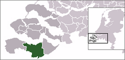 | ||
 The town centre (dark green) and the statistical district (light green) of Philippine in the municipality of Terneuzen. | ||
Coordinates: 51°16′58″N 3°45′31″E / 51.28278°N 3.75861°E / 51.28278; 3.75861Coordinates: 51°16′58″N 3°45′31″E / 51.28278°N 3.75861°E / 51.28278; 3.75861 | ||
| Country | ||
| Province | Zeeland | |
| Municipality | Terneuzen | |
| Population (31 December 2009) | ||
| • Total | 2,127 | |
| Time zone | UTC+1 (CET) | |
| • Summer (DST) | UTC+2 (CEST) | |
Philippine is a town in the Dutch province of Zeeland. It is a part of the municipality of Terneuzen, and lies about 23 km southeast of Vlissingen. It is located close to the border with Belgium, 5 km southwest of the city of Terneuzen. It received city rights in 1506.
Philippine has gained some renown for its mussel restaurants. On the village square there is a fountain in the shape of a mussel.
Philippine was a separate municipality until 1970, when it was merged with Sas van Gent.[1]
In 2001, the town of Philippine had 1,970 inhabitants. The built-up area of the town was 0.60 km², and contained 853 residences.[2]
The statistical area "Philippines", which also can include the surrounding countryside, has a population of around 2,180.[3]
The landlord, Hieronymus Lauweryn, who founded the town in 1505, named it after Philip the Handsome.
Gallery
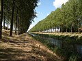
This canal runs adjacent to the northeast boundary of Philippine
Reformed Church in Philippine

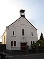
Catholic church of Our Lady at the St. Philips Square


References
^ Ad van der Meer and Onno Boonstra, Repertorium van Nederlandse gemeenten, KNAW, 2006.
^ Statistics Netherlands (CBS), Bevolkingskernen in Nederland 2001. (Statistics are for the continuous built-up area).
^ Statistics Netherlands (CBS), Statline: Kerncijfers wijken en buurten 2003-2005. As of 1 January 2005.
External links
| Wikimedia Commons has media related to Philippine. |
J. Kuyper, Gemeente Atlas van Nederland, 1865-1870, "Philippine". Map of the former municipality, around 1868.- Historical map from the Special Collections of the Utrecht University Library, with explanation by the conservator of maps, Marco van Egmond


