Kwidzyn
| Kwidzyn | |||
|---|---|---|---|
 Photos of Kwidzyn | |||
| |||
 Kwidzyn | |||
Coordinates: 53°44′9″N 18°55′51″E / 53.73583°N 18.93083°E / 53.73583; 18.93083 | |||
| Country | |||
| Voivodeship | Pomeranian | ||
| County | Kwidzyn County | ||
| Gmina | Kwidzyn (urban gmina) | ||
| Established | 11th century | ||
| Town rights | 1233 | ||
| Government | |||
| • Mayor | Andrzej Krzysztof Krzysztofiak | ||
| Area | |||
| • Total | 21.82 km2 (8.42 sq mi) | ||
| Elevation | 42 m (138 ft) | ||
| Population (2006) | |||
| • Total | 37,814 | ||
| • Density | 1,700/km2 (4,500/sq mi) | ||
| Time zone | UTC+1 (CET) | ||
| • Summer (DST) | UTC+2 (CEST) | ||
| Postal code | 82-500 | ||
| Area code(s) | +48 55 | ||
| Car plates | GKW | ||
| Website | http://www.kwidzyn.pl | ||

Kwidzyn (Polish pronunciation: [ˈkfʲid͡zɨn]; Latin: Quedin; German: Marienwerder; Prussian: Kwēdina) is a town in northern Poland on the Liwa river in the Powiśle (right bank of Vistula) region, with 40,008 inhabitants (2004). It has been a part of the Pomeranian Voivodeship since 1999, and was previously in the Elbląg Voivodeship (1975–1998). It is the capital of Kwidzyn County.
Contents
1 History
2 Geography
3 Points of interest
4 Economy
5 Notable people
6 Burials
7 International relations
7.1 Twin towns – sister cities
8 References
9 Sources
10 External links
History

Kwidzyn castle in 2016

Kwidzyn castle in 1912
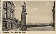
1922 postcard of Hermann Balk Fountain in Kwidzyn

Kwidzyn castle arcs
In 1233, the Teutonic Knights built the Kwidzyn Castle and established the town of Marienwerder (Kwidzyn) the following year. In 1243, the Bishopric of Pomesania received both the town and castle from the Teutonic Order as fiefs, and the settlement became the seat of the Bishops of Pomesania within Prussia.[1] The town was populated by artisans and traders, originating from towns in the northern parts of the German empire. A Teutonic knight, Werner von Orseln, was murdered in Marienburg (Malbork) in 1330. He was buried as one of the first in the newly erected cathedral of the town.
St. Dorothea of Montau lived in Kwidzyn from 1391 until her death in 1394; future pilgrims visiting her shrine would contribute to the flourishing economy.
The Prussian Confederation was founded in the town on March 14, 1440.[2] After the defeat of the Teutonic Knights in the Thirteen Years' War, the western part of their monastic state of the Teutonic Knights would by annexed by the Polish kingdom under the title of Royal Prussia (later on West Prussia). The Bishopric of Ermland situated in the centre of the monastic state was also brought with its Polish name of Warmia under Polish royal control shortly after that date. The remainder, known as East Prussia, to which Marienwerder town (Kwidzyn) belonged, remained an independent but weakened state.
In 1525, East Prussia transformed itself into a secular and Lutheran duchy under the last monastic overlord ('Hochmeister') Albrecht von Ansbach-Hohenzollern, a political foundation only possible with consent of the Polish king. The price had to be paid by becoming a Polish fief. In 1618 the ducal rights were inherited by the Brandenburg branch of the House of Hohenzollern and these dukes broke their ties with the Polish king in 1657 and elevated their realm to the sovereign Kingdom of Prussia in 1701.
The town of Marienwerder (Kwidzyn) meanwhile had become the capital of the East Prussian District of Marienwerder. In 1772, after the First Partition of Poland, resulting in the reunification of Prussia, the new Prussian Province of West Prussia was founded and the Marienwerder district was taken out of the Province of East Prussia, integrated into West Prussia and enlarged with other parts of West Prussia. The name may provoke confusion as, in the course of the 19th century, the government region of Marienwerder was installed to which a range of districts came to belong, one of them being the Marienwerder district. Capital of the larger governmental unit became Marienwerder town (Kwidzyn). Consequently, since then this town was a capital of both the Marienwerder district and the much larger Marienwerder government region.
By the enlargement of its administrative functions, the population of the town started to grow and in 1885, it numbered 8,079. This population was mostly composed of Lutheran inhabitants, many of whom were engaged in trades connected with the manufacturing of sugar, vinegar and brewing as well as dairy farming, fruit growing and the industrial construction of machines.
In 1910, according to the Prussian state census, the district of Marienwerder district had 68,446 inhabitants, 37.8% of which spoke Polish as their mother tongue. Marienwerder town (Kwidzyn) had 25,871 inhabitants, and 9.8% of them spoke Polish as their mother tongue.
In 1919, after World War I, the Marienwerder district was divided. The parts west of the Vistula were incorporated into the Polish Second Republic according to the Treaty of Versailles. Those parts contained 25,313 inhabitants, of which 81.3% spoke Polish. The parts east of the Vistula to which the town Marienwerder-Kwidzyn) belonged, numbered 43,113 inhabitants, 87.6% of which spoke German and these expressed their national preference in anticipation of the definitive allocation and drawing of new national borders. A plébiscite was needed to eventually draw this new state border between Germany and the newly erected Polish republic. During the East Prussian plebiscite, some 95% of the population of the contested eastern parts - the districts of Marienwerder-Kwidzyn and Allenstein-Olsztyn - voted to remain in East Prussia, and consequently in Germany. The vote was largely boycotted by the ethnic Polish minority, confronted by the persecution of Polish activists by German nationalists.
On November 10, 1937, when the Nazi regime was in power in Germany, a Polish private high school was opened in Kwidzyn. It was forcibly closed down on August 25, 1939.[3]
On January 30, 1945 during World War II, the town was captured by the Soviet Red Army. The Red Army established a war hospital in the town for 20,000 people. The town centre was burned and pillaged by Soviet soldiers.
After World War II, the region was placed under Polish administration by the Potsdam Agreement, under territorial changes demanded by the Soviet Union. Most of the people of the town and district were Germans who fled or were expelled by Polish authorities, and were to be replaced with Poles, some of whom had themselves been expelled from the Polish areas annexed by the Soviet Union. In 1947, Ukrainians from the Soviet border regions were forced to settle in the area as a result of Operation Vistula. Burned parts of the town's centre were dismantled to provide material for the rebuilding of Warsaw after its destruction in the Warsaw Uprising.[citation needed]
Geography
Kwidzyn is located on the east bank of the Vistula river, approximately 70 kilometres (43 miles) south of Gdańsk and 145 kilometres (90 miles) southwest of Kaliningrad.
| Year | Inhabitants |
|---|---|
| 1400 | approx. 700 |
| 1572 | approx. 700 |
| 1782 | 3,156 |
| 1783 | 3,297 |
| 1831 | 5,060 |
| 1875 | 7,580 |
| 1880 | 8,238 |
| 1890 | 8,552 |
| 1900 | 9,686 |
| 1905 | 11,819 |
| 1925 | 13,721 |
| 1930 | 13,860 |
| 1933 | 15,548 |
| 1939 | 19,723 |
| 1965 | approx. 13,000 |
| 2006 | 37,814 |
| The above table is based on biased primary sources from the time of Prussian Partition of Poland.[1][4][5][6][7] | |
Points of interest
The Kwidzyn Castle is a partially ruined 14th century Brick Gothic Ordensburg castle of the Teutonic Order, namely the Bishops of Pomesania. A large cathedral built between 1343 and 1384 is connected to the castle. It contains the tombs of three Grand Masters of the Teutonic Knights as well as numerous bishops. A bridge connects the castle to a sewer tower. This tower used to be by a river which has since changed its course, leaving the tower on dry land.
Kwidzyn has a Catholic church and a cathedral castle presently used for the museum of Lower Powiśle.
Other sights include the appellate court for Kwidzyn County, a town hall, and government buildings.
Economy
A branch of International Paper is located in Kwidzyn, as is the Kwidzyn School of Management.
The second biggest employer in Kwidzyn is Jabil, a global electronics manufacturing services company.[8]
The city has lower average crime and unemployment rates when compared to the national average rates of Poland.[8] These lower rates are attributed to sport programs for youth such as MMTS Kwidzyn (handball) and MTS Basket Kwidzyn.[8]
Notable people
Dorothea of Montau (1347–1394), saint
Hans Adolf Erdmann von Auerswald (1792–1848), Prussian general and politician
Rudolf von Auerswald (1795–1866), Prime Minister of Prussia
Hermann von Dechend (1814–1890), first President of the Reichsbank
Rudolf Heidenhain (1834–1897), physiologist
Gustav Cohn (1840–1919), economist
Kurt Rosenfeld (1877–1943), lawyer and politician
Józef Krasnowolski (1879–1939), artist
Fritz Goerdeler (1886–1945), mayor in 1920-33
Joachim Witthöft (1887–1966), general
Kurt-Jürgen Freiherr von Lützow (1892–1961), general
Ida Siekmann (1902–1961), first victim of Berlin Wall
Ernst Tillich (1910–1985), theologian- Bernard Friese (1927–2010), Founder of Gilbern Cars
Hardy Rodenstock (born 1941), music publisher and manager
Wojciech Belon (1952–1985), poet, songwriter and folksinger
Tomasz Piotr Nowak (born 1956), politician
Marek Szulen (born 1975), composer of electronic music
Maciej Silski (born 1976), singer
Burials
Otto Friedrich von der Groeben (1657–1728)- Werner von Orseln
International relations
Twin towns – sister cities
Kwidzyn is twinned with:
 Celle, Germany[9]
 Bar, Ukraine
 Olofström, Sweden

Coat of arms at twin town Celle (Germany), granite artwork below signpost

References
^ ab August Eduard Preuß: Preußische Landes- und Volkskunde. Königsberg 1835, pp. 441–444.
^ Jürgen Sarnowsky: Der Deutsche Orden. Beck, Munich 2007, .mw-parser-output cite.citation{font-style:inherit}.mw-parser-output q{quotes:"""""""'""'"}.mw-parser-output code.cs1-code{color:inherit;background:inherit;border:inherit;padding:inherit}.mw-parser-output .cs1-lock-free a{background:url("//upload.wikimedia.org/wikipedia/commons/thumb/6/65/Lock-green.svg/9px-Lock-green.svg.png")no-repeat;background-position:right .1em center}.mw-parser-output .cs1-lock-limited a,.mw-parser-output .cs1-lock-registration a{background:url("//upload.wikimedia.org/wikipedia/commons/thumb/d/d6/Lock-gray-alt-2.svg/9px-Lock-gray-alt-2.svg.png")no-repeat;background-position:right .1em center}.mw-parser-output .cs1-lock-subscription a{background:url("//upload.wikimedia.org/wikipedia/commons/thumb/a/aa/Lock-red-alt-2.svg/9px-Lock-red-alt-2.svg.png")no-repeat;background-position:right .1em center}.mw-parser-output .cs1-subscription,.mw-parser-output .cs1-registration{color:#555}.mw-parser-output .cs1-subscription span,.mw-parser-output .cs1-registration span{border-bottom:1px dotted;cursor:help}.mw-parser-output .cs1-hidden-error{display:none;font-size:100%}.mw-parser-output .cs1-visible-error{font-size:100%}.mw-parser-output .cs1-subscription,.mw-parser-output .cs1-registration,.mw-parser-output .cs1-format{font-size:95%}.mw-parser-output .cs1-kern-left,.mw-parser-output .cs1-kern-wl-left{padding-left:0.2em}.mw-parser-output .cs1-kern-right,.mw-parser-output .cs1-kern-wl-right{padding-right:0.2em}
ISBN 978-3-406-53628-1, p. 100 ff. (restricted preview).
^ Andreas Lawaty, Wiesław Mincer and Anna Domańska: Deutsch-polnische Beziehungen in Geschichte und Gegenwart – Bibliographie. Vol 2: Religion, Buch, Presse, Wissenschaft, Bildung, Philosophie, Harrassowitz, Wiesbaden,
ISBN 3-447-04243-5, p. 879 (restricted preview)
^ Michael Rademacher: Deutsche Verwaltungsgeschichte Provinz Westpreußen, Kreis Marienwerder (2006)
^ Der Große Brockhaus, 15th edition, Vol. 12, Leipzig 1932, p. 143.
^ Meyers Großes Konversations-Lexikon, 6th edition, Vol. 13, Leipzig and Vienna 1908, p. 299.
^ Johann Friedrich Goldbeck: Vollständige Topographie des Königreichs Preußen. Teil II, Marienwerder 1789, pp. 3–6.
^ abc Turystyka, historia, zabytki. Kwidzyn Moje miasto.
^ "Stadt Celle". www.celle.de. Retrieved 2010-01-05.
Sources
Stephen Turnbull: Crusader Castles of the Teutonic Knights: The Red-Brick Castles of Prussia 1230-1466, October 2003 (eBook, PDF)
External links
| Wikimedia Commons has media related to Kwidzyn. |
Municipal website (in Polish)
- Kwidzyn School of Management
Kwidzyn City Portal (in English)
Coordinates: 53°44′9″N 18°55′51″E / 53.73583°N 18.93083°E / 53.73583; 18.93083
Gminas of Kwidzyn County | ||
|---|---|---|
| Seat |
|  |
| Urban-rural gmina |
| |
| Rural gminas |
| |
Gmina Kwidzyn | ||
|---|---|---|
| Seat (not part of the gmina) |
|  |
| Villages |
| |
Authority control |
|
|---|


