Iles Purpuraires
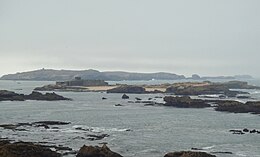 Iles Purpuraires, including Mogador island, seen from the Essaouira citadel | |
 Iles Purpuraires | |
| Geography | |
|---|---|
| Location | North Atlantic Ocean |
| Coordinates | 31°29′50″N 9°47′12″W / 31.49722°N 9.78667°W / 31.49722; -9.78667Coordinates: 31°29′50″N 9°47′12″W / 31.49722°N 9.78667°W / 31.49722; -9.78667 |
| Major islands | Mogador Island |
| Administration | |
Morocco | |
| Region | Marrakesh-Safi |
| Province | Essaouira Province |
Ramsar Wetland | |
| Official name | Archipel et dunes d'Essawira |
| Designated | 15 January 2005 |
| Reference no. | 1469[1] |
Iles Purpuraires are a set of small islands off the western coast of Morocco at the bay located at Essaouira, the largest of which is Mogador Island. These islands were settled in antiquity by the Phoenicians, chiefly to exploit certain marine resources and as a promontory fort. (Hogan, 2007) Roman occupation of western Morocco beginning in the 2nd century BC continued the use of the islets, principally for manufacture of a royal blue dye from certain marine organisms. Neolithic archaeological studies in this area indicate indigenous peoples of western Morocco fished in this locale circa 3000 to 2000 BC. (Trakadas, 2002) The islands have been designated as a protected Ramsar site since 2005.[1]
References
^ ab "Archipel et dunes d'Essawira". Ramsar Sites Information Service. Retrieved 11 September 2018..mw-parser-output cite.citation{font-style:inherit}.mw-parser-output .citation q{quotes:"""""""'""'"}.mw-parser-output .citation .cs1-lock-free a{background:url("//upload.wikimedia.org/wikipedia/commons/thumb/6/65/Lock-green.svg/9px-Lock-green.svg.png")no-repeat;background-position:right .1em center}.mw-parser-output .citation .cs1-lock-limited a,.mw-parser-output .citation .cs1-lock-registration a{background:url("//upload.wikimedia.org/wikipedia/commons/thumb/d/d6/Lock-gray-alt-2.svg/9px-Lock-gray-alt-2.svg.png")no-repeat;background-position:right .1em center}.mw-parser-output .citation .cs1-lock-subscription a{background:url("//upload.wikimedia.org/wikipedia/commons/thumb/a/aa/Lock-red-alt-2.svg/9px-Lock-red-alt-2.svg.png")no-repeat;background-position:right .1em center}.mw-parser-output .cs1-subscription,.mw-parser-output .cs1-registration{color:#555}.mw-parser-output .cs1-subscription span,.mw-parser-output .cs1-registration span{border-bottom:1px dotted;cursor:help}.mw-parser-output .cs1-ws-icon a{background:url("//upload.wikimedia.org/wikipedia/commons/thumb/4/4c/Wikisource-logo.svg/12px-Wikisource-logo.svg.png")no-repeat;background-position:right .1em center}.mw-parser-output code.cs1-code{color:inherit;background:inherit;border:inherit;padding:inherit}.mw-parser-output .cs1-hidden-error{display:none;font-size:100%}.mw-parser-output .cs1-visible-error{font-size:100%}.mw-parser-output .cs1-maint{display:none;color:#33aa33;margin-left:0.3em}.mw-parser-output .cs1-subscription,.mw-parser-output .cs1-registration,.mw-parser-output .cs1-format{font-size:95%}.mw-parser-output .cs1-kern-left,.mw-parser-output .cs1-kern-wl-left{padding-left:0.2em}.mw-parser-output .cs1-kern-right,.mw-parser-output .cs1-kern-wl-right{padding-right:0.2em}
- C.Michael Hogan, Mogador: promontory fort, The Megalithic Portal, ed. Andy Burnham, Nov. 2, 2007 [1]
- Athena Tradakas, Ancient Marine Resource Exploitation in the Western Mediterranean: the Contribution of the fish salting industry of Mauretania Tingitana (Morocco), Institute of Classical Archaeology, Aarhus University, Denmark
This Marrakesh-Safi location article is a stub. You can help Wikipedia by expanding it. |


