Al Diwaniyah
Al Diwaniyah الديوانية | |
|---|---|
City | |
 Al-Diwaniyah at night | |
 Al Diwaniyah Location within Iraq | |
| Coordinates: 32°00′N 45°00′E / 32.000°N 45.000°E / 32.000; 45.000 | |
| Country | |
| Province | Al-Qādisiyyah |
| Population (2012 Est) | |
| • Total | 650,927 |
Al Diwaniyah (Arabic: الديوانية Ad Dīwānīyah), also spelt Diwaniya, is the capital city of Iraq's Al-Qādisiyyah Governorate. In 2002 the population was estimated at 440,927.
Contents
1 Overview
2 Climate
3 Gallery
4 See also
5 References
Overview
The area around Al Diwaniyah, which is well irrigated from the nearby Euphrates river, is often considered to be one on the most fertile parts of Iraq, and is heavily cultivated. The town is located on the main rail transport corridor between Baghdad and Basra.
For birdwatchers, Al-Diwaniyah is a city with a rich bird list, as the city has a wide range of biodiversity. Al-Qadisiyah consists of vast agricultural areas, wetlands, arid zones, and semi-desert areas.
The city is the site of a tire manufacturing plant that once provided tires for much of Iraq. The plant is currently active.[1]
Al-Diwaniyah is the headquarters of the Iraqi Army's 8th Division (Iraq).
Climate
Al Diwaniyah has a hot desert climate (BWh) in the Köppen–Geiger climate classification system.
| Climate data for Ad Diwaniyah | |||||||||||||
|---|---|---|---|---|---|---|---|---|---|---|---|---|---|
| Month | Jan | Feb | Mar | Apr | May | Jun | Jul | Aug | Sep | Oct | Nov | Dec | Year |
| Average high °C (°F) | 16.9 (62.4) | 19.6 (67.3) | 24.2 (75.6) | 29.8 (85.6) | 34.7 (94.5) | 40.9 (105.6) | 42.5 (108.5) | 42.8 (109.0) | 39.9 (103.8) | 34.3 (93.7) | 25.4 (77.7) | 18.4 (65.1) | 30.8 (87.4) |
| Daily mean °C (°F) | 10.5 (50.9) | 12.8 (55.0) | 16.9 (62.4) | 22.2 (72.0) | 27.5 (81.5) | 32.1 (89.8) | 33.5 (92.3) | 33.3 (91.9) | 30.2 (86.4) | 25.1 (77.2) | 17.9 (64.2) | 12.1 (53.8) | 22.8 (73.1) |
| Average low °C (°F) | 4.1 (39.4) | 6.0 (42.8) | 9.7 (49.5) | 14.7 (58.5) | 20.3 (68.5) | 23.4 (74.1) | 24.6 (76.3) | 23.8 (74.8) | 20.6 (69.1) | 16.0 (60.8) | 10.5 (50.9) | 5.9 (42.6) | 15.0 (58.9) |
| Average precipitation mm (inches) | 21 (0.8) | 15 (0.6) | 16 (0.6) | 18 (0.7) | 7 (0.3) | 0 (0) | 0 (0) | 0 (0) | 0 (0) | 2 (0.1) | 15 (0.6) | 23 (0.9) | 117 (4.6) |
| Source: Climate-Data.org[2] | |||||||||||||
Gallery

Central Al Diwaniyah
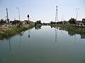
Central Al Diwaniyah


See also
- List of places in Iraq
References
| Wikivoyage has a travel guide for Al Diwaniyah. |
^ Gordon, Michael (2008-08-03). "The Last Battle". New York Times. Retrieved 2008-08-04..mw-parser-output cite.citation{font-style:inherit}.mw-parser-output .citation q{quotes:"""""""'""'"}.mw-parser-output .citation .cs1-lock-free a{background:url("//upload.wikimedia.org/wikipedia/commons/thumb/6/65/Lock-green.svg/9px-Lock-green.svg.png")no-repeat;background-position:right .1em center}.mw-parser-output .citation .cs1-lock-limited a,.mw-parser-output .citation .cs1-lock-registration a{background:url("//upload.wikimedia.org/wikipedia/commons/thumb/d/d6/Lock-gray-alt-2.svg/9px-Lock-gray-alt-2.svg.png")no-repeat;background-position:right .1em center}.mw-parser-output .citation .cs1-lock-subscription a{background:url("//upload.wikimedia.org/wikipedia/commons/thumb/a/aa/Lock-red-alt-2.svg/9px-Lock-red-alt-2.svg.png")no-repeat;background-position:right .1em center}.mw-parser-output .cs1-subscription,.mw-parser-output .cs1-registration{color:#555}.mw-parser-output .cs1-subscription span,.mw-parser-output .cs1-registration span{border-bottom:1px dotted;cursor:help}.mw-parser-output .cs1-ws-icon a{background:url("//upload.wikimedia.org/wikipedia/commons/thumb/4/4c/Wikisource-logo.svg/12px-Wikisource-logo.svg.png")no-repeat;background-position:right .1em center}.mw-parser-output code.cs1-code{color:inherit;background:inherit;border:inherit;padding:inherit}.mw-parser-output .cs1-hidden-error{display:none;font-size:100%}.mw-parser-output .cs1-visible-error{font-size:100%}.mw-parser-output .cs1-maint{display:none;color:#33aa33;margin-left:0.3em}.mw-parser-output .cs1-subscription,.mw-parser-output .cs1-registration,.mw-parser-output .cs1-format{font-size:95%}.mw-parser-output .cs1-kern-left,.mw-parser-output .cs1-kern-wl-left{padding-left:0.2em}.mw-parser-output .cs1-kern-right,.mw-parser-output .cs1-kern-wl-right{padding-right:0.2em}
^
"Climate: Ad Diwaniyah, Iraq". Climate-Data.org.
Coordinates: 31°59′21″N 44°55′29″E / 31.98917°N 44.92472°E / 31.98917; 44.92472


