Amazonas (Venezuelan state)
Amazonas | ||
|---|---|---|
State of Venezuela | ||
| ||
| Motto(s): Honor y Lealtad (English: Honor and Loyalty) | ||
| Anthem: Himno del Estado Amazonas | ||
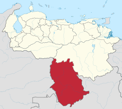 Location within Venezuela | ||
| Country | Venezuela | |
| Created | 1994[c] | |
| Capital | Puerto Ayacucho | |
| Government | ||
| • Governor | Liborio Guarulla (2010–present) | |
| Area | ||
| • Total | 183,500 km2 (70,800 sq mi) | |
| Area rank | 2nd | |
| 19.38% of Venezuela | ||
| Population (2011 est.) | ||
| • Total | 146,480 | |
| • Rank | 24th | |
| 0.3% of Venezuela | ||
| Time zone | UTC-04:00 | |
| ISO 3166 code | VE-Z | |
| Emblematic tree | Caucho (Hevea benthamiana) | |
| Website | web.archive.org/web/20051119152035/http://www.amazonas.gob.ve/ | |
^[c] Until this date, Amazonas had the status of Federal Territory. | ||

Amazonas State (Spanish: Estado Amazonas, IPA: [esˈtaðo amaˈsonas]) is one of the 23 states (estados) into which Venezuela is divided. It covers nearly a fifth of the area of Venezuela, but has less than 1% of Venezuela's population.
The state capital is Puerto Ayacucho. The capital until the early 1900s was San Fernando de Atabapo. Although named after the Amazon River, most of the state is drained by the Orinoco River. Amazonas State covers 176,899 km² and, in 2007, had a population of 142,200. Its density is 0.8 inhabitants per km².
Amazonas has Venezuela's highest proportion of indigenous peoples of Venezuela; these make up only around 1.5% of the population nationwide, but the proportion is nearly 50% in Amazonas.[1]
Contents
1 History
2 Municipalities and municipal seats
3 Population
3.1 Race and ethnicity
4 See also
5 References
6 External links
History
The territory covered by present-day Amazonas was previously part of the Guayana Province, a Province of the Spanish Empire (from 1585) and later of Venezuela (until 1864, when the Provinces of Venezuela were replaced by the States of Venezuela, following the Federal War). Amazonas was created as a state in 1994, having been a Federal Territory since 1864.
Municipalities and municipal seats
| Municipality | Capital | km² | Pop | Map |
|---|---|---|---|---|
| Alto Orinoco Municipality | La Esmeralda | 49.217 km² | 14.222 hab. (2008) |  |
| Atabapo Municipality | San Fernando de Atabapo | 25.062 km² | 12.797 hab. (2007) | 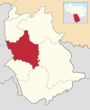 |
| Atures Municipality | Puerto Ayacucho | 7.302 km² | 91.386 hab (2007) | 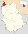 |
| Autana Municipality | Isla Ratón | 12.291 km² | 8.181 hab (2007) |  |
| Manapiare Municipality | San Juan de Manapiare | 32.042 km² | 9.658 hab (2007) | 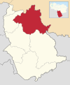 |
| Maroa Municipality | Maroa | 13.082 km² | 8.181 hab (2005) |  |
| Río Negro Municipality | San Carlos de Río Negro | 37.903 km² | 9.658 hab (2007) | 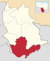 |
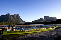
A river near Autana tepui in Amazonas.

The Tobogán de la Selva, near to Puerto Ayacucho.
Population
Race and ethnicity
According to the 2011 Census, the racial composition of the population was:[2]
| Racial composition | Population | % |
|---|---|---|
| Mestizo | N/A | 60.6 |
| White | 54,102 | 34.4 |
| Black | 6,291 | 4.1 |
| Other race | N/A | 0.9 |
See also
- Amazonas Department, Colombia
- Amazonas State, Brazil
- States of Venezuela
References
^ Van Cott (2003), "Andean Indigenous Movements and Constitutional Transformation: Venezuela in Comparative Perspective", Latin American Perspectives 30(1), p52
^ "Resultado Básico del XIV Censo Nacional de Población y Vivienda 2011 (Mayo 2014)" (PDF). Ine.gov.ve. p. 29. Retrieved 8 September 2015..mw-parser-output cite.citation{font-style:inherit}.mw-parser-output .citation q{quotes:"""""""'""'"}.mw-parser-output .citation .cs1-lock-free a{background:url("//upload.wikimedia.org/wikipedia/commons/thumb/6/65/Lock-green.svg/9px-Lock-green.svg.png")no-repeat;background-position:right .1em center}.mw-parser-output .citation .cs1-lock-limited a,.mw-parser-output .citation .cs1-lock-registration a{background:url("//upload.wikimedia.org/wikipedia/commons/thumb/d/d6/Lock-gray-alt-2.svg/9px-Lock-gray-alt-2.svg.png")no-repeat;background-position:right .1em center}.mw-parser-output .citation .cs1-lock-subscription a{background:url("//upload.wikimedia.org/wikipedia/commons/thumb/a/aa/Lock-red-alt-2.svg/9px-Lock-red-alt-2.svg.png")no-repeat;background-position:right .1em center}.mw-parser-output .cs1-subscription,.mw-parser-output .cs1-registration{color:#555}.mw-parser-output .cs1-subscription span,.mw-parser-output .cs1-registration span{border-bottom:1px dotted;cursor:help}.mw-parser-output .cs1-ws-icon a{background:url("//upload.wikimedia.org/wikipedia/commons/thumb/4/4c/Wikisource-logo.svg/12px-Wikisource-logo.svg.png")no-repeat;background-position:right .1em center}.mw-parser-output code.cs1-code{color:inherit;background:inherit;border:inherit;padding:inherit}.mw-parser-output .cs1-hidden-error{display:none;font-size:100%}.mw-parser-output .cs1-visible-error{font-size:100%}.mw-parser-output .cs1-maint{display:none;color:#33aa33;margin-left:0.3em}.mw-parser-output .cs1-subscription,.mw-parser-output .cs1-registration,.mw-parser-output .cs1-format{font-size:95%}.mw-parser-output .cs1-kern-left,.mw-parser-output .cs1-kern-wl-left{padding-left:0.2em}.mw-parser-output .cs1-kern-right,.mw-parser-output .cs1-kern-wl-right{padding-right:0.2em}
External links
| Wikivoyage has a travel guide for Amazonas (Venezuela). |
| Wikimedia Commons has media related to Amazonas (Venezuela). |
- Governor's page
Coordinates: 3°30′N 66°00′W / 3.500°N 66.000°W / 3.500; -66.000
Administrative divisions of Venezuela | ||
|---|---|---|
| Capital District |
| |
| States |
| |
| Dependencies |
| |
| Regions |
| |
| Claimed |
| |


