Randolph County, Illinois
Randolph County, Illinois | |
|---|---|
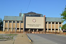 Randolph County Courthouse, Chester | |
| Motto: Where Illinois Began | |
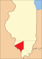
 Location in the U.S. state of Illinois | |
 Illinois's location in the U.S. | |
| Founded | 1795 |
| Named for | Edmund Randolph |
| Seat | Chester |
| Largest city | Chester |
| Area | |
| • Total | 597 sq mi (1,546 km2) |
| • Land | 576 sq mi (1,492 km2) |
| • Water | 22 sq mi (57 km2), 3.6% |
| Population | |
| • (2010) | 33,476 |
| • Density | 58/sq mi (22/km2) |
| Congressional district | 12th |
| Time zone | Central: UTC−6/−5 |
| Website | am.randolphco.org |
Randolph County is a county located in the U.S. state of Illinois. According to the 2010 census, it had a population of 33,476.[1] Its county seat is Chester.[2]
Owing to its role in the state's history, the county motto is "Where Illinois Began." It contains the historically important village of Kaskaskia, Illinois's first capital.
The county is part of Southern Illinois in the southern portion of the state known locally as "Little Egypt", and includes fertile river flats, part of the American Bottom; it is near the Greater St. Louis area.
Contents
1 History
2 Geography
2.1 Climate and weather
2.2 Major highways
2.3 Adjacent counties
3 Demographics
4 Government and infrastructure
5 Politics
6 Media
7 Communities
7.1 Cities
7.2 Villages
7.3 Unincorporated communities
8 See also
9 References
10 External links
History
Randolph County was organized in 1795 out of a part of St. Clair County. It was named in honor of Edmund Randolph, Governor of Virginia. George Rogers Clark of the army of Virginia captured the area from the British on July 4, 1778, near the end of the Revolutionary War. The area then became the seat, for several years, of Illinois County, Virginia, although the Congress of the Confederation legislated the existence of the Northwest Territory on July 13, 1787. Edmund Randolph was Governor of Virginia at the time Virginia ceded the Northwest Territory to the United States. In 1809, when Illinois became a separate territory, Territorial Secretary Nathaniel Pope, in his capacity as acting governor, issued a proclamation establishing Randoloph as one of the Illinois' two original counties. The county's boundaries were last changed in 1827, when land was taken to form Perry County.
The Mississippi River has played a prominent role in the county's history, altering its boundaries in 1881 when it severed the isthmus that connected Kaskaskia to the Illinois mainland, destroying the original village of Kaskaskia and forcing its historic cemetery to be relocated across the river to Fort Kaskaskia. Crains Island [2], southeast of Chester, is another enclave of Illinois west of the Mississippi that was created by a change in the river's course.

Randolph County as it was re-established in 1809. This diagonal border line had been drawn by the Indiana Territorial government in 1803.[3]
Randolph County between 1812 and 1813
Randolph County between 1813 and 1816

Randolph County between 1816 and 1827
Randolph County in 1827, reduced to its current borders


Geography
According to the U.S. Census Bureau, the county has a total area of 597 square miles (1,550 km2), of which 576 square miles (1,490 km2) is land and 22 square miles (57 km2) (3.6%) is water.[4]
The Kaskaskia River flows into the Mississippi River in Randolph County. At this point the Mississippi, which usually defines the border between Illinois and Missouri, is entirely in Illinois. The Mississippi changed its course in the late-nineteenth century, leaving Kaskaskia, the former state capital, on the west side of the river. The boundary of the State, however, follows the old course of the river, leaving Illinois with an enclave on the western shore of the Mississippi River. A smaller enclave, Crains Island, is a few miles further down the river.
Climate and weather
Chester, Illinois | ||||||||||||||||||||||||||||||||||||||||||||||||||||||||||||
|---|---|---|---|---|---|---|---|---|---|---|---|---|---|---|---|---|---|---|---|---|---|---|---|---|---|---|---|---|---|---|---|---|---|---|---|---|---|---|---|---|---|---|---|---|---|---|---|---|---|---|---|---|---|---|---|---|---|---|---|---|
| Climate chart (explanation) | ||||||||||||||||||||||||||||||||||||||||||||||||||||||||||||
| ||||||||||||||||||||||||||||||||||||||||||||||||||||||||||||
| ||||||||||||||||||||||||||||||||||||||||||||||||||||||||||||
In recent years, average temperatures in the county seat of Chester have ranged from a low of 22 °F (−6 °C) in January to a high of 91 °F (33 °C) in July, although a record low of −18 °F (−28 °C) was recorded in January 1985 and a record high of 113 °F (45 °C) was recorded in July 2012. Average monthly precipitation ranged from 1.85 inches (47 mm) in January to 4.30 inches (109 mm) in May.[5]
Major highways
 Illinois Route 3
 Illinois Route 4
 Illinois Route 13
 Illinois Route 150
 Illinois Route 153
 Illinois Route 154
 Illinois Route 155
 Illinois Route 159
Adjacent counties
Monroe County (northwest)
St. Clair County (north)
Washington County (northeast)
Perry County (east)
Jackson County (southeast)
Perry County, Missouri (south)
Ste. Genevieve County, Missouri (southwest)
Randolph County is among the few counties in the United States to border two counties with the same name (Perry County in Missouri and Illinois).
Demographics
| Historical population | |||
|---|---|---|---|
| Census | Pop. | %± | |
| 1820 | 3,492 | — | |
| 1830 | 4,429 | 26.8% | |
| 1840 | 7,944 | 79.4% | |
| 1850 | 11,079 | 39.5% | |
| 1860 | 17,205 | 55.3% | |
| 1870 | 20,859 | 21.2% | |
| 1880 | 25,690 | 23.2% | |
| 1890 | 25,049 | −2.5% | |
| 1900 | 28,001 | 11.8% | |
| 1910 | 29,120 | 4.0% | |
| 1920 | 29,109 | 0.0% | |
| 1930 | 29,313 | 0.7% | |
| 1940 | 33,608 | 14.7% | |
| 1950 | 31,673 | −5.8% | |
| 1960 | 29,988 | −5.3% | |
| 1970 | 31,379 | 4.6% | |
| 1980 | 35,652 | 13.6% | |
| 1990 | 34,583 | −3.0% | |
| 2000 | 33,893 | −2.0% | |
| 2010 | 33,476 | −1.2% | |
| Est. 2016 | 32,621 | [6] | −2.6% |
| U.S. Decennial Census[7] 1790-1960[8] 1900-1990[9] 1990-2000[10] 2010-2013[1] | |||
As of the 2010 United States Census, there were 33,476 people, 12,314 households, and 8,188 families residing in the county.[11] The population density was 58.2 inhabitants per square mile (22.5/km2). There were 13,707 housing units at an average density of 23.8 per square mile (9.2/km2).[4] The racial makeup of the county was 87.6% white, 9.7% black or African American, 0.3% Asian, 0.2% American Indian, 1.2% from other races, and 0.9% from two or more races. Those of Hispanic or Latino origin made up 2.6% of the population.[11] In terms of ancestry, 40.3% were German, 11.3% were Irish, 9.4% were English, and 5.7% were American.[12]
Of the 12,314 households, 29.1% had children under the age of 18 living with them, 52.0% were married couples living together, 10.1% had a female householder with no husband present, 33.5% were non-families, and 28.9% of all households were made up of individuals. The average household size was 2.37 and the average family size was 2.90. The median age was 41.0 years.[11]
The median income for a household in the county was $45,020 and the median income for a family was $55,113. Males had a median income of $43,359 versus $28,376 for females. The per capita income for the county was $19,950. About 7.0% of families and 10.4% of the population were below the poverty line, including 11.9% of those under age 18 and 9.9% of those age 65 or over.[13]
Government and infrastructure
The Illinois Department of Corrections Menard Correctional Center is located in Chester.[14][15] Prior to the January 11, 2003 commutation of death row sentences, male death row inmates were housed in Menard, Tamms, and Pontiac correctional centers. After that date, only Pontiac continued to host the male death row.[16]
Politics
Randolph is a rural conservative county in southern Illinois that has trended Republican in recent presidential elections. Historically, the county was dominated by organized labor and family farms. This put it into the Democratic column. The area might be described as economically populist and socially conservative.[citation needed]
| Year | Republican | Democratic | Third parties |
|---|---|---|---|
2016 | 70.6% 10,023 | 24.2% 3,439 | 5.2% 732 |
2012 | 57.4% 8,290 | 39.9% 5,759 | 2.7% 389 |
2008 | 49.6% 7,538 | 48.6% 7,395 | 1.8% 269 |
2004 | 54.0% 8,076 | 45.3% 6,771 | 0.7% 109 |
2000 | 49.9% 7,127 | 47.6% 6,794 | 2.6% 366 |
1996 | 37.0% 5,422 | 50.7% 7,419 | 12.3% 1,806 |
1992 | 29.6% 4,899 | 51.5% 8,529 | 18.9% 3,137 |
1988 | 48.3% 7,396 | 51.2% 7,844 | 0.5% 78 |
1984 | 59.5% 9,415 | 40.2% 6,355 | 0.4% 59 |
1980 | 56.9% 8,810 | 39.1% 6,052 | 4.1% 632 |
1976 | 48.1% 8,190 | 51.0% 8,693 | 0.9% 155 |
1972 | 60.2% 9,761 | 39.7% 6,440 | 0.1% 14 |
1968 | 50.4% 7,681 | 39.0% 5,953 | 10.6% 1,616 |
1964 | 38.7% 5,803 | 61.3% 9,199 | 0.0% 0 |
1960 | 52.1% 7,988 | 47.9% 7,344 | 0.1% 15 |
1956 | 55.4% 8,439 | 44.5% 6,778 | 0.0% 4 |
1952 | 54.6% 8,427 | 45.3% 6,998 | 0.1% 13 |
1948 | 49.8% 6,867 | 49.7% 6,852 | 0.5% 62 |
1944 | 54.7% 7,518 | 45.1% 6,199 | 0.3% 39 |
1940 | 54.2% 9,333 | 45.3% 7,802 | 0.5% 80 |
1936 | 45.0% 7,057 | 52.5% 8,247 | 2.5% 397 |
1932 | 34.8% 4,747 | 63.3% 8,634 | 2.0% 266 |
1928 | 47.5% 5,739 | 51.7% 6,251 | 0.9% 103 |
1924 | 41.6% 4,527 | 34.3% 3,734 | 24.1% 2,619 |
1920 | 62.5% 6,180 | 32.2% 3,181 | 5.3% 521 |
1916 | 49.1% 5,517 | 48.0% 5,403 | 2.9% 326 |
1912 | 18.3% 1,169 | 50.4% 3,217 | 31.3% 2,000 |
1908 | 47.0% 3,045 | 49.0% 3,172 | 4.0% 256 |
1904 | 52.2% 3,238 | 40.6% 2,518 | 7.3% 451 |
1900 | 47.1% 3,045 | 50.7% 3,278 | 2.3% 146 |
1896 | 48.6% 3,024 | 49.5% 3,081 | 2.0% 124 |
1892 | 43.9% 2,425 | 48.9% 2,702 | 7.3% 401 |
Media
There are two AM radio stations licensed in the county — WHCO 1230AM in Sparta and KSGM 980AM in Chester.
Weekly newspapers in the county are The Randolph County Herald Tribune located in Chester, The County Journal, which is based in Percy and also covers Perry and Jackson Counties, the North County News in Red Bud, and the Sparta News-Plaindealer.
The area is also served by the on-line newspaper based in Chester which is SunTimesNews.com
Communities
Cities
- Chester
- Red Bud
- Sparta
Villages
- Baldwin
- Coulterville
- Ellis Grove
- Evansville
- Kaskaskia
- Percy
- Prairie du Rocher
- Rockwood
- Ruma
- Steeleville
- Tilden
Unincorporated communities
- Blair
- Bremen
- Collins
- Danley
- Dozaville
- Eden
- Fort Gage
- Glenn
- Grigg
- Houston
- Kellogg
- Leanderville
- Marigold
- Menard
- Modoc
- New Palestine
- Prairie
- Preston
- Reily Lake
- Roots
- Schuline
- Shiloh Hill
- Walsh
- Welge
- Wine Hill
See also
- National Register of Historic Places listings in Randolph County, Illinois
References
^ ab "State & County QuickFacts". United States Census Bureau. Retrieved July 8, 2014..mw-parser-output cite.citation{font-style:inherit}.mw-parser-output q{quotes:"""""""'""'"}.mw-parser-output code.cs1-code{color:inherit;background:inherit;border:inherit;padding:inherit}.mw-parser-output .cs1-lock-free a{background:url("//upload.wikimedia.org/wikipedia/commons/thumb/6/65/Lock-green.svg/9px-Lock-green.svg.png")no-repeat;background-position:right .1em center}.mw-parser-output .cs1-lock-limited a,.mw-parser-output .cs1-lock-registration a{background:url("//upload.wikimedia.org/wikipedia/commons/thumb/d/d6/Lock-gray-alt-2.svg/9px-Lock-gray-alt-2.svg.png")no-repeat;background-position:right .1em center}.mw-parser-output .cs1-lock-subscription a{background:url("//upload.wikimedia.org/wikipedia/commons/thumb/a/aa/Lock-red-alt-2.svg/9px-Lock-red-alt-2.svg.png")no-repeat;background-position:right .1em center}.mw-parser-output .cs1-subscription,.mw-parser-output .cs1-registration{color:#555}.mw-parser-output .cs1-subscription span,.mw-parser-output .cs1-registration span{border-bottom:1px dotted;cursor:help}.mw-parser-output .cs1-hidden-error{display:none;font-size:100%}.mw-parser-output .cs1-visible-error{font-size:100%}.mw-parser-output .cs1-subscription,.mw-parser-output .cs1-registration,.mw-parser-output .cs1-format{font-size:95%}.mw-parser-output .cs1-kern-left,.mw-parser-output .cs1-kern-wl-left{padding-left:0.2em}.mw-parser-output .cs1-kern-right,.mw-parser-output .cs1-kern-wl-right{padding-right:0.2em}
^ "Find a County". National Association of Counties. Retrieved 2011-06-07.
^ White, Jesse. Origin and Evolution of Illinois Counties. State of Illinois, March 2010. [1]
^ ab "Population, Housing Units, Area, and Density: 2010 - County". United States Census Bureau. Retrieved 2015-07-12.
^ ab "Monthly Averages for Chester, Illinois". The Weather Channel. Retrieved 2011-01-27.
^ "Population and Housing Unit Estimates". Retrieved June 9, 2017.
^ "U.S. Decennial Census". United States Census Bureau. Retrieved July 8, 2014.
^ "Historical Census Browser". University of Virginia Library. Retrieved July 8, 2014.
^ "Population of Counties by Decennial Census: 1900 to 1990". United States Census Bureau. Retrieved July 8, 2014.
^ "Census 2000 PHC-T-4. Ranking Tables for Counties: 1990 and 2000" (PDF). United States Census Bureau. Retrieved July 8, 2014.
^ abc "DP-1 Profile of General Population and Housing Characteristics: 2010 Demographic Profile Data". United States Census Bureau. Retrieved 2015-07-12.
^ "DP02 SELECTED SOCIAL CHARACTERISTICS IN THE UNITED STATES – 2006-2010 American Community Survey 5-Year Estimates". United States Census Bureau. Retrieved 2015-07-12.
^ "DP03 SELECTED ECONOMIC CHARACTERISTICS – 2006-2010 American Community Survey 5-Year Estimates". United States Census Bureau. Retrieved 2015-07-12.
^ "Menard Correctional Center." Illinois Department of Corrections. Retrieved on September 1, 2010.
^ "Chester city, Illinois Archived 2011-07-28 at the Wayback Machine.." U.S. Census Bureau. Retrieved on September 1, 2010.
^ "DOC Report Online." Illinois Department of Corrections. Retrieved on September 1, 2010.
^ Leip, David. "Dave Leip's Atlas of U.S. Presidential Elections". uselectionatlas.org. Retrieved 7 April 2018.
External links
- KBDZ 93.1 FM Radio
- KSGM AM 980 Radio
- Randolph County Government
- SunTimesNews.com
- Randolph County Herald-Tribune
- North County News
- Sparta News-Plaindealer
Places adjacent to Randolph County, Illinois | ||||||||||
|---|---|---|---|---|---|---|---|---|---|---|
| ||||||||||
Municipalities and communities of Randolph County, Illinois, United States | ||
|---|---|---|
County seat: Chester | ||
| Cities |
| |
| Villages |
| |
| Precincts |
| |
| Unincorporated communities |
| |
Southern Illinois | ||
|---|---|---|
| Counties |
|  |
| Mid-sized cities (25,000+) |
| |
| Small Cities (10,000-25,000) |
| |
| Small Cities (5,000-10,000) |
| |
| Interstates |
| |
| Airports/Military bases |
| |
| Universities |
| |
| Colleges |
| |
| Sports teams based in the Southern Illinois |
| |
Springfield (capital) | ||
| Topics |
|  Seal of Illinois |
| Regions |
| |
| Municipalities |
| |
| Counties |
| |
Coordinates: 38°03′N 89°49′W / 38.05°N 89.82°W / 38.05; -89.82


